
South Mountain Reservation facts for kids
Quick facts for kids South Mountain Reservation |
|
|---|---|

Crater View
|
|

South Mountain Reservation
Location in Essex County, New Jersey
|
|
| Nearest city | Newark, New Jersey |
| Area | 2,047 acres (8.28 km2) |
| Established | 1895 |
| Governing body | Essex County |

South Mountain Reservation is a huge nature reserve in Essex County, New Jersey. It covers about 2,110 acres (which is about 8 square kilometers!). This beautiful park is part of the Essex County Park System. You can find it in parts of Maplewood, Millburn, and West Orange. It's nestled between the first and second ridges of the Watchung Mountains.
This reservation was created from wild lands in the late 1800s. It was designed by the famous Olmsted Brothers firm. The park has stayed mostly wild over the years. It's full of different kinds of trees, tall hemlocks, streams, creeks, ponds, and even waterfalls. From high spots like Crater View, you can see amazing views of the New York and Jersey City skylines. You can also see Elizabeth, Union Township, and Staten Island.
Contents
Fun Things to Do at the Reservation
The South Mountain Reservation has a special area called the South Mountain Recreation Complex. It's packed with fun activities for everyone!
You can visit the Richard J. Codey Arena for ice skating or other events. There's also the Turtle Back Zoo, where you can see many different animals. In 2010, more fun was added with Safari Minigolf and the Treetop Adventure Ropes Course. If you get hungry, McLoone's Boathouse Restaurant opened in 2011 right next to the Orange Reservoir. In 2013, you could even rent paddleboats on the reservoir!
Orange Reservoir: A Big Lake for Fun

The Orange Reservoir is a large lake located in the northern part of the reservation. It's in West Orange and is owned by the City of Orange. This reservoir was built a long time ago in the late 1800s to help provide water for the growing towns.
Today, the reservoir is no longer used for drinking water. Instead, it's becoming a great spot for recreation! The area around the reservoir is part of the Recreation Complex. It includes the miniature golf course and the boathouse restaurant. The county has an agreement to use the reservoir until 2032. This means more improvements for fun activities, like new bridges, are planned for the future.

History of South Mountain Reservation
Revolutionary War History
One important spot in the reservation is Washington Rock. This place has a cool history from the American Revolutionary War. It was once Beacon Signal Station 9, one of 23 signal stations built by General George Washington. These beacons helped soldiers watch for British troops moving around Staten Island and New York City.
On June 23, 1780, the Essex County and Newark Militia were warned from this spot that the British were attacking. The British wanted to reach "the Gap," a natural path to Washington's army. But the American soldiers fought bravely and stopped the British and Hessian troops.
How the Park Was Created
Long ago, in 1860, this area was truly wild! People even saw wolves, bears, and cougars here. There was a reward for catching them. In 1896, a man named John Durand described the mountain as a "wilderness." He said it was full of deer and other wild animals, with streams full of trout. There was plenty of game like partridges, quail, and rabbits. Sometimes, a hungry bear would even wander onto nearby farms!
The South Mountain Reservation began to be formed in 1895 when land was purchased. It took about ten years to buy all the different pieces of land. Frederick Law Olmsted, a famous landscape architect, visited the area and thought it was one of the most beautiful places he had ever seen. His stepson's company, the Olmsted Brothers, designed the park over many years. A lot of the work, like building trails, bridges, and shelters, was done by the Civilian Conservation Corps in the 1930s.
Images for kids
-
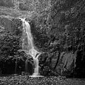
Hemlock Falls is a dramatic feature
-
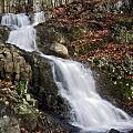
Blackrock Falls


