
Rahway, New Jersey facts for kids
Quick facts for kids
Rahway, New Jersey
|
|||
|---|---|---|---|
|
City
|
|||

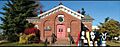
The historic Merchants and Drovers Tavern
|
|||
|
|||

Location of Rahway in Union County, New Jersey (left). Inset map: Location of Union County in New Jersey.
|
|||

Census Bureau map of Rahway, New Jersey
<mapframe text="Interactive map of Rahway, New Jersey" zoom="8" width="250" height="250"> { "type": "ExternalData", "service": "geoshape", "ids": "Q1003082" } </mapframe> |
|||

Rahway, New Jersey
Location in Union County, New Jersey

Rahway, New Jersey
Location in New Jersey

Rahway, New Jersey
Location in the United States
|
|||
| Country | |||
| State | |||
| County | Union | ||
| Incorporated | April 19, 1858 | ||
| Government | |||
| • Type | Faulkner Act (mayor–council) | ||
| • Body | City Council | ||
| Area | |||
| • Total | 4.04 sq mi (10.47 km2) | ||
| • Land | 3.90 sq mi (10.09 km2) | ||
| • Water | 0.14 sq mi (0.38 km2) 3.59% | ||
| Area rank | 295th of 565 in state 12th of 21 in county |
||
| Elevation | 23 ft (7 m) | ||
| Population
(2020)
|
|||
| • Total | 29,556 | ||
| • Estimate
(2023)
|
29,813 | ||
| • Rank | 81st of 565 in state 6th of 21 in county |
||
| • Density | 7,586.2/sq mi (2,929.0/km2) | ||
| • Density rank | 58th of 565 in state 7th of 21 in county |
||
| Time zone | UTC−05:00 (Eastern Standard Time (EST)) | ||
| • Summer (DST) | UTC−04:00 (Eastern (EDT)) | ||
| ZIP Code |
07065
|
||
| Area code(s) | 732 | ||
| FIPS code | 3403961530 | ||
| GNIS feature ID | 0885363 | ||
| Website | |||


Rahway (/ˈrɔːweɪ/) is a city in southern Union County, New Jersey. It's a "bedroom community" for New York City, meaning many people live here and commute to work in New York. Rahway is about 15 miles southwest of Manhattan.
The city is built along the Rahway River, which helped it become an industrial and craft center long ago. Today, Rahway is becoming known for its arts and science industries. It is home to a major company called Merck & Co.
In 2020, Rahway's population was 29,556. This was the highest number of people ever recorded living in the city. The population has been growing steadily over the years.
Contents
- Rahway's Story: A Look at Its Past
- Rahway's Location and Surroundings
- People and Population
- Rahway's Economy and Downtown Life
- Arts and Culture in Rahway
- Parks and Recreation
- Education in Rahway
- Fun Facts About Rahway
- Getting Around Rahway
- Rahway's Climate
- Famous People From Rahway
- Images for kids
- See also
Rahway's Story: A Look at Its Past

Rahway has a rich history, from its first inhabitants to its growth as a modern city.
Early Days: Native Americans and Settlers
Rahway was originally home to the Lenape Native Americans. It is believed the city was named after Rahwack, a local tribal chief.
European settlers arrived in 1664. They bought land from the Lenape. This land included all of what is now Union County. Early towns like Elizabethtown and Woodbridge helped start Rahway. The Seventeenth Century Clark House is one of the oldest buildings in New Jersey.
By the 1700s, Rahway had four main areas. These were Upper Rahway, Bridge Town, Leesville, and Milton.
Revolutionary War and Local Battles
Rahway played a part in the American Revolutionary War. It was close to important locations like Staten Island. In January 1777, American rebels won a battle against the British. About 100 British soldiers died. This fight was called the Battle of Spanktown. Rahway was once known as Spanktown.
The Merchants and Drovers Tavern is a historic building from 1795. It is still an important landmark in Rahway. George Washington visited Rahway in 1789. This was before he became president. A marker tells that he was welcomed by troops here.
After the war, Rahway became home to the first national mint. This mint made a coin with the words E pluribus unum on it. In 1791, Rahway had one of only six post offices in New Jersey.
Growth with Stagecoaches and Industry


Rahway grew because it was on major travel routes. These routes included stagecoach and railroad lines. They connected New York City and Philadelphia. The Rahway River also helped the city's business grow.
Rahway officially became a city on April 19, 1858. This happened as more people moved there. The first city elections were held that day. The city's police department started soon after.
Many big companies came to Rahway. These included the Regina Music Box Company and Wheatena. Most importantly, Merck & Co. started in Rahway in 1903.
Modern Rahway: From Decline to Revival
After World War II, many factories in Rahway closed. This caused the city's downtown area to struggle.
However, Rahway began a plan to improve its downtown in the late 1990s. They built new homes, a hotel, and art galleries. This helped bring new life to the city.
Rahway's Location and Surroundings

Rahway covers about 4 square miles (10.47 square kilometers). Most of this area is land.
Rahway shares borders with other towns. These include Clark and Linden in Union County. It also borders Woodbridge Township in Middlesex County.

The Rahway River flows through the city. It enters from Clark and leaves towards Linden and Woodbridge. The river eventually flows into the Arthur Kill.
People and Population

Rahway's population has grown over the years. In 1860, about 7,130 people lived here. By 2020, the population reached 29,556. This shows that more and more people are choosing Rahway as their home.
Rahway's Economy and Downtown Life
A Great Downtown Area


In 2020, downtown Rahway was recognized as a "Great Downtown." It was praised for being a lively place. People can easily walk around, shop, eat, and enjoy art. It is also very diverse. The downtown area is right next to the train station.
A new hotel, the Watt Hotel, opened in 2019. It has 100 rooms and a rooftop bar. This bar offers great views of the city.
Rahway's downtown has seen many improvements since the 1990s. New restaurants and art galleries have opened. The old Rahway Theatre became the Union County Performing Arts Center. This theater had a big renovation.
Healthcare in Rahway
Robert Wood Johnson University Hospital, Rahway, is a local hospital. It helps people in the area. It is part of the RWJBarnabas Health System.
Merck & Co. in Rahway
Merck & Co. is a very large company. In 2021, they announced they would move their main office back to Rahway. Their research campus in Rahway is the city's largest private employer. Merck completed this move in 2024.
Arts and Culture in Rahway
Local News and Information
Rahway has several ways for people to stay informed.
- TAPInto Rahway is a website that covers local news.
- Rahway Rising focuses on city council meetings and new developments.
- Rahway Is Happening! shares news about arts, festivals, and local businesses.
- Our Town Rahway is a free newspaper mailed to residents.
- Union News Daily covers news for Union County, including Rahway.
Library and Other Media

The Rahway Public Library was damaged by a flood in 1999. A new library was built and opened in 2004. It is in a safer location near the Rahway River. The old library site now has tennis courts and a playground.
Rahway also has a Black-owned bookstore. It is called Bridges Book Center Afro-American Research Library & Museum. It was opened in 1970 by historian Eva Bridges.
Performing and Visual Arts

Rahway has become a center for arts. The Union County Performing Arts Center is a major landmark. It hosts many shows and events.
Places of Worship
Rahway has many historic churches.
- The First Presbyterian Church of Rahway was founded in 1741.
- Divine Mercy Parish is a Roman Catholic church built in 1888.
- The Seventh-day Adventist Church was built in 1865.
- The Ebenezer AME Church is one of the oldest AME churches in the country. It started in 1826.
- Trinity Methodist Church was founded in 1849.
Parks and Recreation
City Parks
Rahway has over ten parks. The most famous is Rahway River Park. This park is maintained by Union County. Part of it is also in Clark.
The Rahway River Park Pool
The Walter E. Ulrich swimming pool in Rahway River Park was updated in 2021. It now has a fun splash area for kids. The pool is open to all Union County residents for a fee. It was built in 1929.
Education in Rahway
The Rahway Public Schools serve students from pre-kindergarten through high school. The district has six schools. In the 2020–21 school year, about 4,056 students attended these schools.
The schools are:
- Grover Cleveland Elementary School (PreK-6)
- Franklin Elementary School (PreK-6)
- Madison Elementary School (PreK-6)
- Roosevelt Elementary School (PreK-6)
- Rahway 7th & 8th Grade Academy (grades 7-8)
- Rahway High School (grades 9-12)
Fun Facts About Rahway
Marquis de Lafayette's Visit
From 1824 to 1825, the French Marquis de Lafayette toured the United States. He was a hero of the American Revolutionary War. He stopped at the Peace Tavern in Rahway during his trip.
Nikola Tesla's Company
In the 1880s, famous inventor Nikola Tesla started his company, Tesla Electric Light & Manufacturing, in Rahway.
Legends of Pirate Treasure
Old stories say that Captain William Kidd buried treasure near Rahway. The treasure was supposedly hidden on the south bank of the Rahway River. A Lenape chief named Ra-wa-rah is said to have seen the burial. Ra-wa-rah is the person Rahway is named after.
East Jersey State Prison
East Jersey State Prison is often called Rahway State Prison. However, it is actually located in Woodbridge Township. The prison's mailing address is in Rahway, which causes the confusion. Its name was changed in 1988. The prison has been featured in movies like Ocean's Eleven and Lock Up.
Getting Around Rahway
_just_north_of_Randolph_Avenue_in_Rahway,_Union_County,_New_Jersey.jpg)
Roads and Highways
Rahway has many miles of roads. Major roads include U.S. Route 1/9, Route 27, and Route 35. The city is also close to the Garden State Parkway and the New Jersey Turnpike.
Public Transportation

NJ Transit offers bus and train services in Rahway. The 115 bus route goes to Midtown Manhattan. The 48 line goes to Elizabeth and Perth Amboy.
The Rahway Train Station serves two train lines. These are the North Jersey Coast Line and Northeast Corridor Line. The station was renovated in 1999. A new parking garage opened in 2005. A train ride to New York City's Pennsylvania Station takes about 38 minutes.
Airport Access
Newark Liberty International Airport is about 10 miles northeast of Rahway. It's a short drive or train ride away.
Rahway's Climate
Rahway has a climate with hot, humid summers. Winters are generally mild to cool. This type of weather is called a humid subtropical climate.
Famous People From Rahway


Many interesting people have connections to Rahway. Here are a few:
- Juliette Atkinson (1873–1944), a famous tennis player and three-time U.S. Open champion.
- Abraham Clark (1725–1794), one of the signers of the Declaration of Independence.
- Dion Dawkins (born 1994), an offensive tackle for the Buffalo Bills in the NFL.
- Milton Friedman (1912–2006), a Nobel Prize-winning economist.
- Antonio Garay (born 1979), a defensive tackle who played for the San Diego Chargers.
- Carl Sagan (1934–1996), a famous astronomer and writer. He won a Pulitzer Prize.
- Nikola Tesla (1856–1943), a brilliant inventor who started a company in Rahway.
- Shanice Williams (born 1996), an actress who starred as Dorothy in The Wiz Live!.
Images for kids
-
The Gallery Space, an art gallery in Rahway.
See also
 In Spanish: Rahway para niños
