
Sandy Hook facts for kids
Quick facts for kids Sandy Hook |
|
|---|---|

Sandy Hook seen from an airplane (looking west) on its approach to JFK International Airport in New York City
|
|

Sandy Hook
Location in Monmouth County, New Jersey
|
|
| Location | Middletown Township, Monmouth County, New Jersey, United States |
| Coordinates | 40°27′11″N 73°59′42″W / 40.4530°N 73.9950°W |
| Offshore water bodies | Atlantic Ocean (to the east) Shrewsbury River (to the west) |
| Elevation | 7 feet (2 m) |
| Length | 6 miles (9.7 km) |
| Width | 0.1 to 1.0 mile (0.16 to 1.61 km) |
| Area | 2,044 acres (827 ha) |
| Depth | 250 to 300 feet (76 to 91 m) |
| Formed by | Wisconsin glaciation period |
| Geology | Spit |
| Age | Last Glacial Maximum ("LGM"; ≈25,000 years old) |
| Operator | National Park Service |
| Designation | Barrier spit |

Sandy Hook is a long, narrow strip of land in Middletown Township, Monmouth County, New Jersey, United States. It is about 6 miles (9.7 km) long. Its width changes from 0.1 to 1.0 mile (0.16 to 1.6 km). This landform is at the northern end of the Jersey Shore. It helps protect the southern entrance of Lower New York Bay from the Atlantic Ocean.
The Dutch people first called this area "Sant Hoek." The English word "Hook" comes from the Dutch word "Hoek." This word means "corner" or "angle." It describes a "spit of land" that curves. For over 300 years, special guides called Sandy Hook pilots have helped ships. They guide vessels safely across the Sandy Hook bar.
Most of Sandy Hook is a national park area. The National Park Service takes care of it. It is part of the Sandy Hook Unit of Gateway National Recreation Area.
Contents
What is Sandy Hook?

Sandy Hook is a large sand spit. It is also called a barrier spit. It extends from a barrier peninsula along the New Jersey coast. The Shrewsbury River separates it from the mainland. On its western side, Sandy Hook encloses Sandy Hook Bay. This bay is a triangular part of Raritan Bay.
The peninsula covers about 2,044 acres (8.27 km²). Henry Hudson discovered this area. Historically, Sandy Hook was a good place for ships to anchor. They would wait there before going into Upper New York Harbor.
Sandy Hook is part of Middletown Township. However, it does not touch the rest of the township. This is not a problem because it is a federal area. The town of Highlands is located near the southern part of Sandy Hook.
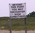
The federal government owns Sandy Hook. The National Park Service manages most of it. This area is known as the Sandy Hook Unit of Gateway National Recreation Area. The eastern side has public beaches. These include North Beach, Gunnison Beach, and South Beach. The southern part has public beaches and fishing spots. There is also a restaurant called SeaGull's Nest. The beaches facing the ocean are very popular. Many people visit them in summer. Ferries bring beachgoers to the area.
A special high school called M.A.S.T. (The Marine Academy of Science and Technology) was at the tip of Sandy Hook. Hurricane Sandy damaged the school in 2012. It was rebuilt the next year.
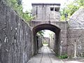
The Sandy Hook Lighthouse is inside the old fort grounds. The Marine Academy of Science and Technology (MAST) is also there. It is a special high school. At the entrance to Fort Hancock, you can find Guardian Park. This park has two Nike missiles. Some buildings at Fort Hancock are closed. They are not safe to enter.
Military History of Sandy Hook
The old U.S. Army base, Fort Hancock, is at the north end of Sandy Hook. It is now open to the public. The Sandy Hook Proving Ground was used for many years. It was a testing site for weapons. This started after the Civil War and lasted until 1919. Then, the facility moved to Aberdeen, Maryland. Later, it became a Nike missile defense site.
The Sandy Hook Nike missile station is one of the few still standing. Most of the fort's old gun batteries are closed to visitors. This is because they are unsafe. But Battery Potter and Battery Gunnison are exceptions. Battery Potter often offers tours on weekends. Battery Gunnison is being restored by volunteers. It has two large 6-inch (152 mm) M1900 guns. These guns were put there in 1976. Guided tours show visitors a Nike missile. You can also see the missile firing platforms and a radar station. This station has computers from the 1960s. A 20-inch Rodman gun from the Civil War is also in the park. This was a very large experimental gun.
North of Fort Hancock, on the western side, is an active United States Coast Guard station. This was one of the first Life Saving Stations. It was built in 1848. The location changed over the years. This area is managed by the Department of Homeland Security. It is not open to the public.
Fun Things to Do at Sandy Hook
The beaches along the Atlantic Ocean side of Sandy Hook are popular. These include North Beach, Gunnison Beach, and the Southern Beaches (A, B, C, D, E). They have parking lots, lifeguards, and restrooms. There are also food stands in the summer. Pets are not allowed on these beaches after March 15 each year.
The western shore of Sandy Hook is different. It has large areas of sand and trails. There is also a paved path. This side does not have lifeguards or restrooms. Cyclists and kite surfers enjoy these areas. Dogs are allowed here if they are on a leash.
Some rules are different at Sandy Hook because it is a federal park. Federal laws apply here. A small offense outside the park might be a federal crime inside.
There are places to stay near Sandy Hook. These include bed and breakfasts like Sandy Hook Cottage. They are located in Highlands. Eating options have changed since Superstorm Sandy. The storm destroyed the only restaurant on the island. Now, you can find food trucks on the peninsula. Nearby, there are local restaurants like Bahr's Landing. The Mule Barn Tavern opened near the lighthouse in 2023.
Local activities include a special lifeguard tournament in July. You can rent boats for fishing, parties, and tours. There is a paved path for biking, rollerblading, and walking. The Henry Hudson Trail starts in Highlands, New Jersey. It is nine miles (14 km) long. It goes from Aberdeen to Atlantic Highlands. This trail is also good for wheelchairs.
The northern tip of Sandy Hook is the end point for a long swim. This swim is 16.1 miles (25.9 km) long. It starts from the Battery in Manhattan. It goes through the Narrows and into Lower New York Bay. The first person to complete this swim was Alfred Brown in 1913. He finished in 13 hours and 38 minutes. Gertrude Ederle swam the same course in 1925. She did it in 7 hours and 11 minutes. This was before her famous English Channel swim.
How to Get to Sandy Hook
The main road to Sandy Hook is Route 36. The road to the peninsula branches off Route 36. This happens at the northern end of Sea Bright. It then becomes Hartshorne Drive inside the park. The Highlands-Sea Bright Bridge carries Route 36 traffic. It crosses the Shrewsbury River. This bridge connects Highlands to Sea Bright.
A bicycle path runs next to the main road. The SeaStreak ferry also goes to Sandy Hook from Manhattan in the summer.
Sandy Hook's Weather
Sandy Hook has a humid subtropical climate. This means it has warm, humid summers. Winters are generally mild. Most summer days have some humidity. A cool afternoon sea breeze helps. But sometimes it can get very hot. The highest temperature recorded was 99.7°F (37.6°C) in August 2001.
July is usually the wettest month. This is when most thunderstorms happen. The most rain in one day was 5.61 inches (142 mm) in August 2011. In winter, the average coldest temperature is 6.3°F (-14.3°C). The coldest ever was -3.0°F (-19.4°C) in January 1985. Sometimes, it feels even colder due to strong winds.
Sandy Hook gets about 18 to 24 inches (46 to 61 cm) of snow each winter. February is usually the snowiest month. This is when big winter storms called "nor'easters" are common.
| Climate data for Sandy Hook, 1981-2010 normals, extremes 1981-2019 | |||||||||||||
|---|---|---|---|---|---|---|---|---|---|---|---|---|---|
| Month | Jan | Feb | Mar | Apr | May | Jun | Jul | Aug | Sep | Oct | Nov | Dec | Year |
| Record high °F (°C) | 70.2 (21.2) |
77.6 (25.3) |
82.1 (27.8) |
90.1 (32.3) |
94.3 (34.6) |
95.3 (35.2) |
99.4 (37.4) |
99.7 (37.6) |
96.2 (35.7) |
92.1 (33.4) |
77.5 (25.3) |
74.6 (23.7) |
99.7 (37.6) |
| Mean daily maximum °F (°C) | 39.1 (3.9) |
41.9 (5.5) |
48.7 (9.3) |
58.3 (14.6) |
68.0 (20.0) |
77.7 (25.4) |
82.8 (28.2) |
81.7 (27.6) |
75.4 (24.1) |
64.4 (18.0) |
54.5 (12.5) |
44.5 (6.9) |
61.5 (16.4) |
| Daily mean °F (°C) | 32.7 (0.4) |
34.9 (1.6) |
41.2 (5.1) |
50.6 (10.3) |
60.4 (15.8) |
70.1 (21.2) |
75.5 (24.2) |
74.7 (23.7) |
68.3 (20.2) |
57.1 (13.9) |
47.8 (8.8) |
38.4 (3.6) |
54.4 (12.4) |
| Mean daily minimum °F (°C) | 26.3 (−3.2) |
28.0 (−2.2) |
33.7 (0.9) |
43.0 (6.1) |
52.8 (11.6) |
62.5 (16.9) |
68.3 (20.2) |
67.7 (19.8) |
61.1 (16.2) |
49.7 (9.8) |
41.2 (5.1) |
32.2 (0.1) |
47.3 (8.5) |
| Record low °F (°C) | −3.0 (−19.4) |
2.3 (−16.5) |
10.0 (−12.2) |
19.1 (−7.2) |
40.2 (4.6) |
48.2 (9.0) |
54.0 (12.2) |
49.4 (9.7) |
42.9 (6.1) |
33.4 (0.8) |
17.1 (−8.3) |
1.6 (−16.9) |
−3.0 (−19.4) |
| Average precipitation inches (mm) | 3.27 (83) |
2.55 (65) |
3.63 (92) |
4.01 (102) |
3.67 (93) |
3.96 (101) |
4.57 (116) |
3.92 (100) |
3.54 (90) |
3.69 (94) |
3.32 (84) |
3.77 (96) |
43.90 (1,115) |
| Average relative humidity (%) | 66.3 | 62.5 | 61.6 | 62.8 | 66.8 | 70.1 | 70.4 | 70.8 | 71.9 | 68.7 | 67.3 | 65.9 | 67.1 |
| Average dew point °F (°C) | 22.7 (−5.2) |
23.4 (−4.8) |
29.0 (−1.7) |
38.4 (3.6) |
49.3 (9.6) |
59.9 (15.5) |
65.2 (18.4) |
64.6 (18.1) |
58.9 (14.9) |
46.9 (8.3) |
37.5 (3.1) |
28.0 (−2.2) |
43.7 (6.5) |
| Source: PRISM | |||||||||||||
| Climate data for Sandy Hook Buoy, NJ (Ocean Water Temperature) | |||||||||||||
|---|---|---|---|---|---|---|---|---|---|---|---|---|---|
| Month | Jan | Feb | Mar | Apr | May | Jun | Jul | Aug | Sep | Oct | Nov | Dec | Year |
| Daily mean °F (°C) | 37 (3) |
36 (2) |
40 (4) |
46 (8) |
55 (13) |
62 (17) |
69 (21) |
72 (22) |
68 (20) |
59 (15) |
51 (11) |
43 (6) |
53 (12) |
| Source: NOAA | |||||||||||||
Plants and Nature at Sandy Hook
Sandy Hook's natural plant life would mostly be Northern Cordgrass. This type of grass grows in coastal areas. The area's plant hardiness zone is 7b. This means the average coldest temperature in winter is 6.3°F (-14.3°C). Plants usually start to grow new leaves around March 23. Fall colors typically appear in early November.
Images for kids
-
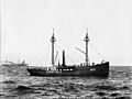
Lightship #51 at Sandy Hook in the 1890s.
-
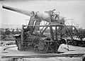
Aiming a 14-inch gun at the Sandy Hook Proving Ground
-
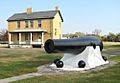
A 20-inch Rodman gun with shells
-
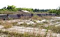
Abandoned gun platforms at the Sandy Hook Proving Ground
-
Part of a mortar battery near Sandy Hook Light
-
One of the many beaches on Sandy Hook.


.jpg)
