Highlands, New Jersey facts for kids
- See also New York–New Jersey Highlands for the northwestern part of New Jersey.
Quick facts for kids
Highlands, New Jersey
|
||
|---|---|---|
|
Borough
|
||
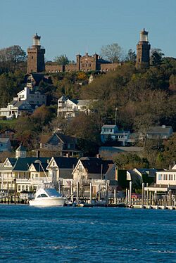
The eastern shore of Highlands borough, topped on a bluff by the Twin Lights of the Navesink
|
||
|
||
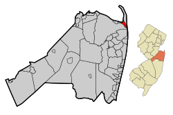
Location of Highlands in Monmouth County highlighted in red (left). Inset map: Location of Monmouth County in New Jersey highlighted in orange (right).
|
||
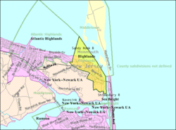
Census Bureau map of Highlands, New Jersey
|
||
| Country | ||
| State | ||
| County | Monmouth | |
| Incorporated | March 22, 1900 | |
| Government | ||
| • Type | Faulkner Act (small municipality) | |
| • Body | Borough Council | |
| Area | ||
| • Total | 1.39 sq mi (3.59 km2) | |
| • Land | 0.74 sq mi (1.92 km2) | |
| • Water | 0.65 sq mi (1.67 km2) 46.47% | |
| Area rank | 462nd of 565 in state 39th of 53 in county |
|
| Elevation | 13 ft (4 m) | |
| Population
(2020)
|
||
| • Total | 4,621 | |
| • Estimate
(2023)
|
4,329 | |
| • Rank | 392nd of 565 in state 35th of 53 in county |
|
| • Density | 6,244.6/sq mi (2,411.1/km2) | |
| • Density rank | 85th of 565 in state 8th of 53 in county |
|
| Time zone | UTC−05:00 (Eastern (EST)) | |
| • Summer (DST) | UTC−04:00 (Eastern (EDT)) | |
| ZIP Code |
07732
|
|
| Area code(s) | 732 exchanges: 291, 708, 872 | |
| FIPS code | 3402531500 | |
| GNIS feature ID | 0885253 | |
| Website | ||
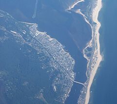
Highlands is a small town, called a borough, located in northern Monmouth County, New Jersey. It's a historic community right on the water, part of the Raritan Bay area. Many people who live here travel to New York City for work, making it a "commuter town."
In 2020, about 4,621 people lived in Highlands. The eastern part of the town sits on a high bluff that looks out over Sandy Hook Bay, the entrance to New York Harbor, and the Atlantic Ocean. This high land is how the borough got its name. At the top of this bluff, you can see the famous Navesink Twin Lights.
Highlands officially became a borough on March 22, 1900. It was formed from parts of Middletown Township. Later, in 1914, more parts of Middletown Township were added. Highlands was also part of a plan to improve the economy of the Raritan Bayshore area. This plan focused on downtown areas, neighborhoods, maritime history, and nature.
On October 29, 2012, Hurricane Sandy hit the East Coast. Highlands was badly damaged, with many homes and businesses affected.
Exploring Highlands' Past
Highlands has a rich history, starting with early explorers and Native Americans.
Early Explorers and Native Americans
- In 1525, Giovanni da Verrazzano explored the area we now call Highlands.
- Over the next 200 years, English and Dutch settlers arrived.
- Even in the 1900s, many immigrants saw the tall hills of the Navesink Highlands, which are almost 300 feet (91 m) high.
The Minisink Trail was an old path used by Native Americans. It started on the upper Delaware River and ended at the Navesink River. "Navesink" means "good fishing spot" in the local language. Tribes like the Algonquin and Lenni Lenape used this trail. They came to fish and find clams during the summer. The Newasunks, Raritans, and Sachem Papomorga were the main tribes who lived and traded here.
In 1526, a year after Verrazzano, Portuguese explorer Estevan Gomez visited. He made the first maps of the area. On these maps, Sandy Hook was first drawn and called "Cabo de Arenas," meaning "Cape of Sands."
In 1609, Henry Hudson sailed into Sandy Hook Bay. He described the land as "very good" with "goodly oaks and some currants." Sadly, one of Hudson's crew members was the first person killed by Native Americans in the area.
Years later, Dutch traders came to Highlands. William Reape traded land with the local natives for rum, blankets, and gunpowder. The Dutch named the land "Rensselaer's Hoeck." But in 1664, British settlers took over and renamed it "Portland."
In 1677, Richard Hartshorne bought a large piece of land from the Native Americans. This gave him control of most of Sandy Hook and Highlands, then called "Portland Poynt." Hartshorne and his family were the first people to live there permanently.
Highlands' Role in Defense
Early settlers quickly saw how important Highlands and Sandy Hook were for defending the country. People here could warn New York about approaching enemy ships. They could also guide ships safely into New York Harbor.
In 1762, New York merchants bought land from the Hartshorne family for a lighthouse. Two years later, the Sandy Hook Lighthouse was lit for the first time.
The hills of Highlands and Sandy Hook were also important during the American Revolutionary War. They were key locations for both the British and American armies. When the British fleet arrived in 1776, British supporters built forts. With British help, they held Sandy Hook for the rest of the war.
The Story of Captain Joshua Huddy
Captain Joshua Huddy was a local militia member. He chased groups of Loyalist (Tory) refugees. These Loyalists would raid the area, looking for American rebels. Huddy became a target for them.
One Loyalist raid from Sandy Hook ended with Huddy's house being set on fire. Huddy agreed to surrender if they helped put out the fire. They agreed and took him prisoner. But the fire attracted Huddy's neighbors and the local militia. They chased the Loyalists and caught them before they reached their boats. Huddy escaped during the fight.
However, two years later, Loyalists captured Huddy again. They brought him to Gravelly Point in Highlands. He was allowed to write his will. Then, he was hanged. This was done because Captain Philip White, a Loyalist, had been captured by Rebels and shot. Huddy was not involved in White's death, as he was in a British prison at the time. Patriots carried Huddy's body to Freehold for burial. Today, a monument in Huddy Park honors Captain Joshua Huddy.
Highlands as a Tourist Spot
In 1796, the first hotel in Highlands was built. More hotels followed until the War of 1812. After the war, tourism grew again. New hotels appeared on Sandy Hook and in Highlands. Many new homes were built, and visitors came by boat.
Famous author James Fenimore Cooper, who wrote Last of the Mohicans, was inspired by Highlands for his novel Water Witch. Walt Whitman, a well-known American poet, wrote about his trips to Highlands in his journals and poems called "Fancies at Navesink."
By 1880, Highlands was full of hotels, beach pavilions, and private clubs. It was a great time for the town. Trains and steamships brought vacationers after the American Civil War. New York theater producers and famous actors built summer homes here. Harper's Magazine even sent journalists to write about Highlands in the 1870s and 1880s.
Bridges and Transportation
The Seashore Railroad was built on Sandy Hook in 1865. A ferry service took passengers from Highlands to a hotel on Sandy Hook. In 1872, a bridge was built, and the ferry stopped. This new drawbridge was about 1,500 feet (457 m) long and 18 feet (5.5 m) wide. It cost $35,000. It closed for three years after a schooner hit it in 1875.
By 1883, a railroad reached Atlantic Highlands. In 1892, the old drawbridge at Highlands was torn down. A new railroad bridge was built by the New Jersey Central Railroad Company. This new bridge, used by trains, cars, and people walking, opened in 1892.
On Lighthouse Hill, you'll find the Twin Lights, a very historic site. Built in 1862, it was special for many reasons:
- It was the first twin lighthouse.
- It was the first electric-powered light.
- It was the first sight of America for many incoming ships.
- It was the first in the nation to use the Fresnel lens (a special type of lens for lighthouses).
- It was the first to use wireless telegraphy.
- It was the site of the first experiments with radar.
Lighthouse Hill (also called Beacon Hill) was used for a beacon as early as 1746. This was during a war between England and France. The beacon, which burned whale oil, warned sailors and also told citizens that French ships might be coming. During the Revolutionary War, it served the same purpose, but the enemy was Britain.
In 1899, Guglielmo Marconi, who invented wireless telegraphy, showed his invention at the Twin Lights. This allowed the New York Herald newspaper to get news of the 1899 America's Cup boat races first.
Highlands in the 20th Century
By the 1920s, Highlands was a very popular place for tourists. However, by 1932, steamboat services on the Shrewsbury and Navesink Rivers ended.
Before World War II, the northern tower of the Twin Lights was used for early radar experiments. These tests were so successful that after the war, radar became a main tool for navigation. Because of this, the government decided to stop using the Twin Lights as an active lighthouse.
In 1900, when Highlands became a borough, it passed a rule. This rule stopped horses, cows, and pigs from running loose in the streets.
By 1920, making, selling, or transporting alcohol was against the law (this was during Prohibition). But "rum-running" (smuggling alcohol) was common along New Jersey's coast. Highlands became a main port for this illegal trade. Highlands also had great boat-building places. They could make boats faster than the authorities could catch them. The Jersey Skiff, designed and built in Highlands, became the main boat used for smuggling.
Highlands became famous for sport fishing in the 1920s. Even today, many boats can be seen in the rivers, bays, and ocean. People fish for fluke, bluefish, striped bass, or whiting.
Clamming was also very important here. Native Americans clammed, and early settlers learned from them. In 1890, a writer said that clams were as important to Parkertown as whales once were to Nantucket.
Gertrude Ederle: A Swimming Legend
Gertrude Ederle spent all her summers in Highlands. She learned to swim at the beach on Miller Street. She would train by swimming from Sandy Hook to the Highlands Bridge. This swim took her two hours and forty minutes. She trained for her famous English Channel swim in 1926.
Gertrude Ederle became the first woman to swim the English Channel. She was also the first woman to receive a ticker-tape parade on Broadway in New York City. In 1975, she attended the dedication of a park in Highlands named in her honor.
In 1975, all military bases on Sandy Hook (except the U.S. Coast Guard) were closed. The land was given to the National Park Service. It became part of the Gateway National Recreation Area.
In 2012, during Hurricane Sandy, Highlands was badly damaged. A storm surge of almost 10 feet (3.0 m) swept in from the bay. Most homes and businesses were damaged or destroyed. There were plans for a $25 million project to raise the town by about 10 feet (3.0 m) to prevent future flooding.
Highlands' Location and Weather

Highlands covers about 1.39 square miles (3.59 km2). About 0.74 square miles (1.92 km2) is land, and 0.65 square miles (1.67 km2) is water.
Some smaller communities within Highlands include Parkertown and Waterwitch. Highlands shares borders with other towns in Monmouth County: Atlantic Highlands, Middletown Township, and Sea Bright.
Climate in Highlands
Highlands has a humid subtropical climate. This means it has hot, humid summers and generally mild to cool winters.
Education in Highlands
Highlands has its own school district for younger students.
Highlands School District
The Highlands School District serves students from pre-kindergarten through sixth grade. These students attend Highlands Elementary School. For the 2022–23 school year, the school had 169 students and 22.1 teachers. This means there were about 7.6 students for every teacher.
Henry Hudson Regional High School
For seventh through twelfth grades, students go to Henry Hudson Regional High School. This high school serves students from both Atlantic Highlands and Highlands. In the 2022–23 school year, the high school had 296 students and 39.2 teachers. This also means about 7.6 students per teacher.
The high school's board of education has nine members. Five of these seats are for Highlands, based on its population. In September 2023, voters in both Atlantic Highlands and Highlands approved a plan. This plan will combine the two K–6 districts with the Henry Hudson regional district. This will create one K–12 school district starting in the 2024–25 school year.
Getting Around Highlands
Highlands has several ways to travel, including roads and public transportation.
Roads and Highways
As of 2010, Highlands had about 15.19 miles (24.45 km) of roads. Most of these (12.50 miles or 20.12 km) are maintained by the town itself.
New Jersey State Route 36 is the main highway that goes through Highlands. On the east side of town, Route 36 connects to Sea Bright using the Highlands-Sea Bright Bridge.
Public Transportation
- NJ Transit offers local bus service on the 834 route. This bus travels between Highlands and Red Bank.
- Academy Bus provides bus service to Midtown Manhattan (at the Port Authority Bus Terminal) and to Wall Street.
- SeaStreak offers ferry service to Manhattan from Conner's Ferry Landing. There are three morning trips that stop at Pier 11/Wall Street and then the East 34th Street Ferry Landing. Six ferry trips return each weekday evening.
People from Highlands
Highlands has been home to several notable people:
- Gertrude Ederle (1905–2003): A famous swimmer who was the first woman to swim across the English Channel. She learned to swim in Highlands during her summers there.
- John J. Flemm (1896–1974): An industrialist and politician who started the Flemm Lead Company.
- Walt Flanagan (born 1967): A comic book store manager, TV personality, and comic book artist.
- Bryan Johnson (born 1967): A co-host of the Tell 'Em Steve-Dave! podcast and a star of Comic Book Men.
- Jason Mewes (born 1974): An actor known for his role as Jay in the duo Jay and Silent Bob.
- Frankie Montecalvo (born 1990): A racing driver who won the 2015 Pirelli World Challenge GTA Driver's Champion title.
See also
 In Spanish: Highlands (Nueva Jersey) para niños
 | Claudette Colvin |
 | Myrlie Evers-Williams |
 | Alberta Odell Jones |


