Navesink Highlands facts for kids
Quick facts for kids Navesink Highlands |
|
|---|---|
| Atlantic Highlands | |

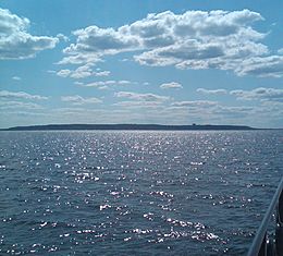
Navesink Highlands seen from the Atlantic Ocean while on approach to New York Harbor
|
|
| Highest point | |
| Peak | Crawford Hill |
| Elevation | 391 ft (119 m) |
| Dimensions | |
| Length | 18 mi (29 km) east–west |
| Geography | |
| Country | United States |
| State | New Jersey |
| Geology | |
| Age of rock | Cretaceous/Tertiary |
| Type of rock | sedimentary |
The Navesink Highlands are a group of low hills and high areas along the Atlantic coast in New Jersey, United States. They are also called the Atlantic Highlands. These hills can be over 350 feet (107 meters) tall. The highest point is Crawford Hill, which is 391 feet (119 meters) high. This makes it the tallest spot in Monmouth County. The part of the Navesink Highlands facing the ocean is the tallest "headland" (a piece of land sticking out into the sea) on the East Coast south of Maine. The highest point here is Mount Mitchill, which is 266 feet (81 meters) tall.
Contents
The Navesink Highlands stretch from west to east along the southern shore of Raritan Bay. This bay is part of New York Bay. All of the Navesink Highlands are located within Monmouth County. A thin strip of land called Sandy Hook is in front of the ocean side of the Highlands. It is separated from the hills by the narrow Shrewsbury River.
The western parts of the Highlands have the highest elevations. These areas are sometimes called the Mount Pleasant Hills. Important hills in this area include Beacon Hill, Telegraph Hill, and Crawford Hill. Beacon Hill is often thought to be the tallest, but it is 373 feet (114 meters) high. The actual tallest point is Crawford Hill, followed by Telegraph Hill.
For example, Bell Labs (now AT&T) built their famous Holmdel Horn Antenna on top of Crawford Hill. Also, the Army chose Telegraph Hill for a main Nike missile control center. The Mount Pleasant area includes parts of Holmdel and Marlboro. These areas are over 300 feet (91 meters) high.
How do the Highlands affect weather?
The higher elevation of the Mount Pleasant region can create a small "microclimate." This means the weather can be slightly different there. In winter, the Mount Pleasant area might get more snow than lower areas. This happens because temperature usually drops as you go higher. The ocean's influence means the hills often get snow when it's 31 degrees Fahrenheit (minus 0.5 degrees Celsius). At the same time, lower areas might get mixed rain and snow or just rain.
The hills of the Navesink Highlands are made of layers of hardened sand, mud, and gravel. These layers were lifted up from the Atlantic Coastal Plain. Scientists believe this uplift happened because of something called glacial rebound. This is when land rises after heavy glaciers (large ice sheets) melt away. Other geological processes might also be happening.
The current height of the hills is partly due to their structure. The top layer of the Highlands is called the Cohansey Formation. It is made of sand, gravel, and strong ironstone. This hard layer acts like a cap on the highest parts of the Highlands. It protects the softer layers underneath, like the Navesink Formation, from wearing away easily.
The Navesink Highlands offer many fun things to do and learn. You can go hiking, fishing, or visit historical places. You can even look for fossils! Holmdel Park is located in the Mount Pleasant part of the range. It is famous for its challenging cross country courses.
Here are some parks, nature preserves, and historical sites you can visit, listed from east to west:
- Navesink Twin Lights Museum
- Hartshorne Woods Park
- Mount Mitchill Scenic Overlook County Park
- Huber Woods
- Poricy Park
- Deep Cut Gardens
- Tatum Park
- Holmdel Park
 | Ernest Everett Just |
 | Mary Jackson |
 | Emmett Chappelle |
 | Marie Maynard Daly |

