Hartshorne Woods Park facts for kids
Quick facts for kids Hartshorne Woods Park |
|
|---|---|

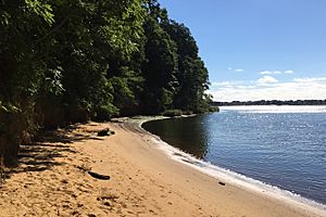
Black Fish Cove in the Rocky Point Section
|
|
| Lua error in Module:Location_map at line 420: attempt to index field 'wikibase' (a nil value). | |
| Type | Public Park |
| Area | 736 acres (298 ha) |
| Created | 1974 |
| Operated by | Monmouth County |
Hartshorne Woods Park (pronounced: hearts horn) is a huge park in Monmouth County, New Jersey, covering about 736 acres! It's located in New Jersey's Bayshore Region. This park is a great place to explore, with 16 miles of trails, old military bunkers, and a small beach where you can even go fishing. The park is divided into three main parts: the Buttermilk Valley Section, the Monmouth Hills Section, and the Rocky Point Section.
Contents
A Look Back in Time: Park History
The park gets its name from Richard Hartshorne. He bought this land from the Lenape people way back in 1670.
The eastern part of the park, called Rocky Point, was once a military site. During World War Two, it was home to a Coast Artillery site known as Battery Lewis. This was a place where big guns were set up to protect the coast.
Later, the Highlands Air Force Station was built here. This was a special radar station that helped watch the skies for airplanes. The military also used the Highlands Army Air Defense Site (HAADS) to support Nike missile batteries in the area. These missiles were part of the country's defense system. The Air Force closed its station in 1966, and the Army stopped using HAADS in 1974.
In 2017, a very large 16-inch gun from the US Navy was placed on display at Battery Lewis. This type of gun was originally a spare for the famous Iowa-class battleships, which were huge warships.
Exploring the Trails
Hartshorne Woods Park has many trails for different activities. You can walk, hike, ride horses, or even go mountain biking! The trails are marked to help you know how challenging they are.
Trail Difficulty Guide:
- Green Circles mean: Easy Trails for a relaxed walk.
- Blue Squares mean: Moderate Trails for hikers, horseback riders, and mountain bikers.
- Black Diamonds mean: Challenging Trails for experienced hikers, horseback riders, and mountain bikers.
Buttermilk Valley Trails
This section has trails that are mostly easy to moderate.
- Kings Hollow Trail - An easy loop that is 0.7 miles long.
- Candlestick Trail - An easy 1.5-mile trail with a great view at the Navesink Overlook.
- Laurel Ridge Trail - A moderate 2.5-mile loop.
Monmouth Hills Trails
This area offers more challenging trails.
- Cuesta Ridge Trail - A moderate trail that is 1.6 miles long.
- Grand Tour Trail - A challenging 3.1-mile trail for experienced adventurers.
Rocky Point Trails
The Rocky Point section has a mix of easy and challenging trails, plus interesting historical spots.
- Lewis Overlook - An easy 0.2-mile loop. There's a trail to the top of Battery Lewis with amazing views.
- Battery Loop - A moderate 1.3-mile loop with a paved surface.
- Black Fish Cove - A moderate 0.3-mile trail. It's a steep path down to the fishing pier.
- Command Loop - A moderate 0.4-mile loop with a paved surface.
- Bunker Loop - A moderate 0.3-mile trail that takes you near the old military bunkers.
- Rocky Point Trail - A challenging 4.1-mile trail for those looking for a longer adventure.
 | Valerie Thomas |
 | Frederick McKinley Jones |
 | George Edward Alcorn Jr. |
 | Thomas Mensah |


