
Highlands Air Force Station facts for kids
Quick facts for kids Highlands Air Force StationUSAF transmitter call sign: "Jitney" |
|
|---|---|
| Part of Air Defense Command |
|
| Coordinates | 40°23′29″N 073°59′38″W / 40.39139°N 73.99389°W |
| Type | General Surveillance Radar Station |
| Code | L-12: 1948 Lashup Radar Network P-9: 1949 ADC permanent network Z-9: 1963 July 31 NORAD network |
| Site information | |
| Controlled by | |
| Site history | |
| In use | 1948-1966 |
| Garrison information | |
| Past commanders |
Major Weston F. Griffith (1955-1961) |
| Garrison | |
Highlands Air Force Station was a military base in Middletown Township, close to the town of Highlands, New Jersey. This station used radar to help guide friendly planes and track others. It was an important part of defense networks like the Lashup Radar Network and the Semi-Automatic Ground Environment (SAGE) system. It also helped provide radar coverage for the Highlands Army Air Defense Site.
Today, the land where the station once stood, about 240 acres, is part of Rocky Point section in Hartshorne Woods Park. This park is managed by the Monmouth County Parks System.
The Navesink Military Reservation (also known as the Highlands Military Reservation) was added to the National Register of Historic Places on October 13, 2015. This means it's recognized as an important historical site.

Contents
History of the Site
Early Uses of the Highlands
The Navesink Highlands area has a long history of being important for navigation and defense. As early as 1746, there was a sea navigation beacon here. Later, in 1828, the first Navesink Twin Lights lighthouse was built. The lighthouses you see there today were built in 1862.
Before the American Civil War, in 1859, people experimented with flag signaling (called Wig-Wag Signaling) from the Navesink Highlands. They used these signals to communicate with Fort Tompkins on Staten Island. In 1899, the famous inventor Guglielmo Marconi even set up a radio station near the lighthouses to report on the America's Cup boat races.
Coastal Defense and Early Radar Tests
|
Navesink Military Reservation Historic District
|
|

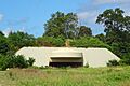
Battery Lewis - Casemate front
|
|

Location in Monmouth County, New Jersey

Location in New Jersey

Location in the United States
|
|
| Location | Grand Tour Road and Portland Road, Middletown Township, New Jersey |
|---|---|
| NRHP reference No. | 15000011 |
| Significant dates | |
| Added to NRHP | October 13, 2015 |
During World War I in 1917, large cannons were placed on the Navesink Highlands to defend the coast. These cannons were called Battery Hartshorne. They were later removed in 1920.
In the 1930s, scientists started experimenting with radar at the Twin Lights lighthouse. In 1935, the U.S. Army Signal Corps successfully used radar to track an airplane with a searchlight. By 1939, an early radar system, the SCR-268, was shown off at the lighthouse.
From 1942 to 1944, the Navesink Military Reservation was built. This included Battery Isaac N. Lewis, which had two very large 16-inch guns, and Battery 219, with two 6-inch guns. These batteries were part of the Harbor Defenses of New York and were crucial for protecting New York during World War II. After the war, these large gun defenses were no longer needed, and the guns were removed in 1948.
The Twin Lights Radar Station
During World War II, the Twin Lights area also had an Army radar site called Site 8A. This site sent radar information to a control center in New York City. In 1939, an important demonstration happened here for the Secretary of War. Radar data from this site and another in Connecticut were combined to track a B-17 bomber formation.
From 1942 to 1945, the site used a Westinghouse SCR-271 radar for early warning of enemy planes. The 608th Signal Aircraft Warning Battalion operated this site.
After World War II, the Cold War began. The United States became worried about possible attacks from Soviet long-range bombers. In 1948, the United States Air Force (USAF) decided to set up radar stations in the northeastern U.S. The 646th Aircraft Control and Warning Squadron was activated at the Twin Lights Lashup Site L-12. They used advanced radar systems to send information to a control center in New York.
In December 1950, the 646th Squadron moved to the Navesink Military Reservation with a new General Electric AN/CPS-6 Radar. In July 1951, this site was named P-9, becoming the 9th permanent radar site in the nation. In December 1953, the Navesink Military Reservation was officially renamed Highlands Air Force Station. More powerful radar systems were added over the years to improve surveillance.
The SAGE System Era
In 1958, Highlands Air Force Station started sending its radar data to the Semi Automatic Ground Environment (SAGE) system. SAGE was a huge computer network designed to track enemy aircraft and guide interceptor planes and missiles. The data from Highlands went to a SAGE Direction Center at McGuire Air Force Base.
Highlands Air Force Station was also the first place in the nation to use a General Electric AN/FPS-7 Radar for long-range surveillance. This radar was important for the Martin AN/FSG-1 Antiaircraft Defense System, which helped guide Nike missiles. The station was a command post for the New York-Philadelphia Defense Area and was known as Nike Site NY-55DC.
A radar station called Texas Tower 4 was located offshore in the Atlantic Ocean. It was an annex of Highlands Air Force Station and was operated by the 646th Radar Squadron. Sadly, this tower collapsed into the ocean on January 15, 1961, and 28 people died.
On July 31, 1963, the site was renamed NORAD ID Z-9. NORAD stands for North American Aerospace Defense Command, which is a joint organization of the U.S. and Canada that watches for threats in the air and space.
In November 1964, it was announced that the Air Force operations at Highlands would close. The 646th Radar Squadron was officially shut down on July 1, 1966.
After the Air Force left, the Highlands Army Air Defense Site (HAADS) was set up in 1966. This site used a new system to guide Nike missiles. The Army continued to use the site until 1974, when the Nike missile program ended. Most of the buildings were taken down in the 1980s and 1990s. Today, you can still see the concrete remains of Battery Lewis, Battery 219, and the Plotting and Switchboard Bunker.
The Site Today
The area where Highlands Air Force Station once stood is now part of Hartshorne Woods Park. In January 2017, a large 16-inch gun, which was once a spare for the famous Iowa-class battleships of the U.S. Navy, was put on display in one of the old gun positions of Battery Lewis.
Images for kids
-
Battery Lewis - Casemate front
