
Coney Island facts for kids
Quick facts for kids
Coney Island
|
|
|---|---|
|
Neighborhood
|
|
.jpg)
Coney Island beach, amusement parks, and high-rises, as seen from the pier in June 2016
|
|
| Nickname(s):
"Playground of the World"
|
|
| Country | |
| State | |
| City | New York City |
| Borough | Brooklyn |
| Community District | Brooklyn 13 |
| Settled | 17th century |
| Founded by | Dutch settlers |
| Area | |
| • Total | 1.790 km2 (0.691 sq mi) |
| Population | |
| • Total | 24,711 |
| • Density | 13,805/km2 (35,755/sq mi) |
| Time zone | UTC−5 (Eastern) |
| • Summer (DST) | UTC−4 (EDT) |
| ZIP Code |
11224
|
| Area code | 718, 347, 929, and 917 |
Coney Island is a famous neighborhood and fun entertainment area in the southwestern part of Brooklyn, a borough of New York City. It's bordered by Brighton Beach to the east, the ocean to the south and west, and Gravesend to the north. The wider Coney Island area also includes Brighton Beach and Manhattan Beach.
Coney Island used to be a real island! But in the early 1900s, people filled in parts of the water around it. This connected it to the rest of Long Island, turning it into a peninsula (land surrounded by water on three sides).
People aren't totally sure where the name "Coney Island" came from. By the mid-1800s, it became a popular seaside resort, a place where people went to relax by the ocean. Later, amusement parks were built there. Coney Island was most popular in the first half of the 1900s. After World War II, it became less popular, and some of its old buildings were torn down. But in the 2000s, new attractions like Maimonides Park (a baseball stadium) and new rides helped bring the fun back!
About 32,000 people lived in Coney Island in 2010. It's a diverse neighborhood with people from many different backgrounds.
Coney Island is part of Brooklyn Community District 13. Its main ZIP Code is 11224. The New York City Police Department's 60th Precinct keeps the area safe. Fire services are provided by the New York City Fire Department. Coney Island has good public transportation with the New York City Subway and bus routes. It also has several public schools.
Contents
- Exploring Coney Island's Location and Weather
- The Mystery of Coney Island's Name
- Coney Island's Exciting History
- Fun Parks and Attractions at Coney Island
- Who Lives in Coney Island?
- Keeping Coney Island Safe
- Learning in Coney Island
- Getting Around Coney Island
- Coney Island in Movies and More
- Famous People from Coney Island
- Images for kids
- See also
Exploring Coney Island's Location and Weather
Where is Coney Island Located?

Coney Island is on the western part of a peninsula that stretches into Lower New York Bay. This peninsula is about 4 miles (6.4 km) long and 0.5 miles (0.8 km) wide. To its northeast is Sheepshead Bay, and to its northwest are Gravesend Bay and Coney Island Creek.
Coney Island used to be a true island, separated from Brooklyn by Coney Island Creek. But in the 1920s and 1930s, a large part of the creek was filled in. This connected the island to the mainland, making it a peninsula.
How Coney Island's Beaches are Maintained
The beaches at Coney Island are not completely natural anymore. Sand that would normally build up on the beaches is blocked by a structure called a jetty at Breezy Point, Queens. To keep the beaches wide and sandy, new sand is added regularly. This process is called beach nourishment. The sand is held in place by about two dozen structures called groynes.
Two large parks, Kaiser Park and Coney Island Creek Park, are located on the northwest side of the peninsula along Coney Island Creek. A study in 2023 found that parts of Coney Island are slowly sinking. This is mainly because some areas were built on filled-in land.
Coney Island's Climate and Weather
Coney Island has a humid subtropical climate, which means it has hot, humid summers and mild winters. The area is in hardiness zone 7b, which tells gardeners what plants can survive the winter there.
| Climate data for Coney Island, Brooklyn | |||||||||||||
|---|---|---|---|---|---|---|---|---|---|---|---|---|---|
| Month | Jan | Feb | Mar | Apr | May | Jun | Jul | Aug | Sep | Oct | Nov | Dec | Year |
| Record high °F (°C) | 70 (21) |
73 (23) |
83 (28) |
93 (34) |
98 (37) |
99 (37) |
105 (41) |
101 (38) |
98 (37) |
91 (33) |
80 (27) |
75 (24) |
105 (41) |
| Mean daily maximum °F (°C) | 39 (4) |
42 (6) |
50 (10) |
60 (16) |
70 (21) |
79 (26) |
84 (29) |
83 (28) |
76 (24) |
65 (18) |
54 (12) |
44 (7) |
62 (17) |
| Mean daily minimum °F (°C) | 25 (−4) |
27 (−3) |
34 (1) |
43 (6) |
53 (12) |
63 (17) |
69 (21) |
67 (19) |
60 (16) |
49 (9) |
40 (4) |
31 (−1) |
47 (8) |
| Record low °F (°C) | −4 (−20) |
−2 (−19) |
7 (−14) |
19 (−7) |
35 (2) |
44 (7) |
51 (11) |
50 (10) |
39 (4) |
29 (−2) |
17 (−8) |
−1 (−18) |
−4 (−20) |
| Average precipitation inches (mm) | 3.86 (98) |
2.99 (76) |
4.07 (103) |
4.03 (102) |
4.40 (112) |
3.61 (92) |
4.45 (113) |
4.16 (106) |
4.12 (105) |
3.41 (87) |
3.86 (98) |
3.63 (92) |
46.56 (1,183) |
| Average snowfall inches (cm) | 6.7 (17) |
7.5 (19) |
3.9 (9.9) |
0.7 (1.8) |
0 (0) |
0 (0) |
0 (0) |
0 (0) |
0 (0) |
0 (0) |
0.3 (0.76) |
3.6 (9.1) |
22.7 (58) |
The Mystery of Coney Island's Name
The first people to live in this area were the Lenape Native Americans. They called the land Narrioch. This name might have meant "land without shadows" or "always in light," because of its sunny beaches. It could also mean "point" or "corner of land."
When Dutch settlers arrived in the 1600s, they made maps. On these maps, the westernmost sandy area was called Conyne Eylandt. The name "Coney Island" became common in the early 1800s.
There are a few ideas about how "Coney Island" got its name:
- Some think it came from a Native American tribe called the Konoh or Konoi.
- Another idea is that it was named after John Colman, a sailor on Henry Hudson's ship, who was killed by natives in 1609.
- A popular theory is that it came from the Dutch word for rabbit, "konijn." This would mean "Rabbit Island," because many wild rabbits supposedly lived there. The English word "coney" also means rabbit.
- Some believe an Irish captain named it after Coney Island in Ireland, which also has rabbits.
Even historians aren't sure which story is true! Some say rabbits were only brought to the island after people settled there.
Coney Island's Exciting History
Early Days: From Islands to Peninsula
_Chart_of_the_entrance_of_Hudson%27s_River,_from_Sandy_Hook_to_New_York_-_with_the_banks,_depths_of_water,_sailing-marks,_%26ca_(NYPL_b14099970-1222740).png)
The Lenape people originally lived in the Coney Island area. They called it Narrioch, meaning "land without shadows" or "always in light" because of its sunny beaches. In the early 1600s, the Dutch started their colony of New Amsterdam nearby. As more Dutch settlers arrived, the Native American population decreased. In 1645, the entire southwestern part of what would become Brooklyn was bought from a Native American elder for a gun, a blanket, and a kettle.
When Europeans first arrived, Coney Island wasn't one big piece of land. It was several smaller islands. These islands kept changing shape because of the ocean's tides and storms, and also because people living there reshaped the land. The westernmost island was called Coney Island.
East of Coney Island was a peninsula called Coney Hook. In 1750, a canal was dug through it, turning Coney Hook into Pine Island. East of Pine Island was the largest section, called Gysbert's Island. It had the most farmland and stretched through today's Brighton Beach and Manhattan Beach.
Each island was separated by water that could only be crossed at low tide. By the late 1700s, the sand had shifted so much that the water passages between the islands started to close. People began filling them in, eventually connecting all the islands into the single Coney Island we know today.
How Coney Island Became a Resort

Developing Coney Island has always been a topic of debate. When the first buildings went up around the 1830s, some people wanted to keep the island as a natural park. Later, in the early 1900s, New York City tried to take back the beach area, which had become covered with bath houses and other buildings. The city wanted to create a public boardwalk and beach.
The Hotel Boom
.jpg)
Coney Island started to become a popular vacation spot after 1829. That year, a company built the first bridge connecting the island to the mainland. They also built Shell Road across the island to the beaches. The first hotel, Coney Island House, opened that same year.
Because Coney Island was close to Manhattan but far enough away to feel like a real vacation, wealthy people started visiting in the 1830s and 1840s. Carriages and steamships made the trip faster. In 1847, a ferry line opened, allowing middle-class people to visit too.
In 1868, William A. Engeman built a large resort called "Brighton Beach" in 1878. It was named after a famous English resort. This hotel could host thousands of people. Soon after, the Brooklyn, Flatbush, and Coney Island Railway (today's BMT Brighton Line) opened, making it even easier to get there.
Around the same time, a wealthy banker named August Corbin developed Manhattan Beach. He built a special railway for his two fancy hotels, the Manhattan Beach Hotel and the Oriental Hotel. These hotels were for the very rich.
Another railroad, the Prospect Park and Coney Island Railroad, also brought visitors to West Brighton. For a small fee, people could ride to the beach. An "Iron Tower" and "Camera Obscura" offered amazing views of the coast. By the late 1800s, Coney Island was a major resort with hotels, bathhouses, and shows.
The Rise of Theme Parks

Between about 1880 and World War II, Coney Island was the biggest amusement area in the United States. Millions of people visited each year. It had three large amusement parks: Luna Park, Dreamland, and Steeplechase Park. There were also many smaller rides and attractions.
Coney Island was a place for new technology. Electric lights, roller coasters, and even baby incubators were some of the new things seen there in the early 1900s. This continued until the end of World War II, with famous structures like the Parachute Jump and Wonder Wheel.

In 1876, Charles I. D. Looff, a woodcarver from Denmark, built the first carousel and amusement ride at Coney Island. It had hand-carved horses and animals. Musicians played music, and riders could try to grab small iron rings. A ride cost five cents.
From 1885 to 1896, a seven-story building shaped like an elephant, called the Elephantine Colossus, greeted immigrants arriving in New York. It was seen even before the Statue of Liberty! The famous Coney Island "Funny Face" logo is over 100 years old.
When the Brooklyn Rapid Transit Company connected Brooklyn to Manhattan by subway in the early 1900s, Coney Island became even more popular. It was easy for people to visit for a day trip to escape the summer heat. The opening of the New West End Terminal in 1919 brought in Coney Island's busiest time.
Since the 1920s, the land north of the boardwalk and south of Surf Avenue has been set aside for amusement and recreation only.
Coney Island Becomes a Peninsula
For a long time, Coney Island was still an island, separated from Brooklyn by the 3-mile-long Coney Island Creek. There were plans to make the creek a shipping canal, but these were never finished. In the 1920s and 1930s, parts of the creek were filled in to build the Belt Parkway. More land was added in 1962 for the Verrazano–Narrows Bridge. This turned the island into a peninsula.
Changes After World War II

After World War II, Coney Island's popularity started to decline. Air conditioning in homes and movie theaters meant people didn't need to go to the beach to cool off. Cars allowed people to visit less crowded state parks like Jones Beach.
Luna Park closed in 1946 after fires. The closing of Steeplechase Park in 1964 also hurt the area.
Robert Moses, a powerful city planner, made many changes. In 1949, he moved the boardwalk back, tearing down many buildings. He also cleared land for the New York Aquarium and the Abe Stark Rink. Critics said he took too much land, leaving empty lots. Later, he tried to rezone the entire peninsula for homes, but after many complaints, the area with amusements was protected.
The Fred Trump Era

In 1964, Steeplechase Park, Coney Island's last big theme park, closed. The land was sold to developer Fred Trump, the father of Donald Trump. Fred Trump wanted to build luxury apartments there. He spent ten years fighting in court to change the land's zoning, but it remained zoned only for amusements. He eventually rented the land to Norman Kaufman, who ran a small amusement park there.
With fewer people visiting, many amusement owners left their properties. In the late 1970s, the city thought about bringing gambling casinos to Coney Island, like in Atlantic City. This idea caused land prices to go up, and many rides were torn down, but gambling was never allowed. This left many empty lots.

In 1979, the city bought the Steeplechase Park land from Fred Trump. They wanted to attract a new developer to build a large theme park and casino. But the land stayed empty for five more years.
New Plans and Changes in the 1980s and 1990s

In the mid-1980s, a businessman named Horace Bullard wanted to rebuild Steeplechase Park. He bought land near the old park, including the site of a large roller coaster called Thunderbolt. His plan was to combine his land with the Steeplechase property to create a huge theme park. The city and state approved his project in 1986. However, the project faced delays and legal battles.
In 1994, when Rudy Giuliani became mayor, he changed the plan. Instead of a theme park, he decided to build a baseball stadium on the Steeplechase Park site. Giuliani wanted to bring a minor-league baseball team to Brooklyn. The stadium was built, and the team was named the Brooklyn Cyclones. The stadium was later named Maimonides Park.
Thor Equities and Modern Revitalization

In 2003, Mayor Michael Bloomberg became interested in making Coney Island a site for the 2012 Summer Olympics. After New York City lost the bid, plans focused on restoring Coney Island as a year-round destination. This worried some amusement owners, whose businesses were only open seasonally.
A company called Thor Equities started buying up property in the amusement area. In 2005, Thor's founder, Joe Sitt, announced plans for a large hotel resort with rides and amusements.

Astroland, a major amusement park since 1962, was sold to Thor Equities in 2006. In 2007, Thor released plans for a new amusement park called Coney Island Park. They proposed a $1.5 billion project to add hotels, shops, movies, an indoor water park, and new roller coasters.
Astroland closed in 2008. A new version of Dreamland opened in 2009, and a new Luna Park opened in 2010.
In 2009, the city approved a plan to build new housing and "preserve, in perpetuity, the open amusement area rides that everyone knows and loves."
Coney Island in the 2010s

Today, Coney Island has Luna Park and Deno's Wonder Wheel Amusement Park, plus other rides. In April 2011, the first new roller coasters in 80 years opened, helping to bring more fun back to the area.
In 2012, Hurricane Sandy caused a lot of damage to the amusement parks, the Aquarium, and businesses. But Luna Park reopened in March 2013, and the Aquarium started rebuilding.
Fun Parks and Attractions at Coney Island
Coney Island has two main amusement parks: Luna Park and Deno's Wonder Wheel Amusement Park. There are also other rides and attractions not part of these parks. Many different companies own and run these attractions. Coney Island also has games like skeeball and ball tossing, plus a sideshow with unique acts.
Famous Rides You Can Still Enjoy
Coney Island has three rides that are considered historic landmarks. One is a New York City landmark, one is on the National Register of Historic Places, and one is both!
- The Wonder Wheel, which opened in 1920, is a giant steel Ferris wheel. It has both cars that stay still and cars that slide along a track, making the ride extra exciting! It can hold 144 riders and is 150 feet (46 m) tall. The Wonder Wheel became a city landmark in 1989.
- The B&B Carousell (spelled with two L's) is Coney Island's last old-fashioned carousel. It was built around 1906–1909 and has a traditional fairground organ for music. It was moved to Luna Park's Steeplechase Plaza in 2013 and is on the National Register of Historic Places.
- The Coney Island Cyclone, opened in 1927, is one of the oldest wooden roller coasters still running in the United States. It has an 85-foot (26 m) drop that goes down at a steep 58-degree angle! The City of New York owns the Cyclone, and Luna Park operates it. The Cyclone became a city landmark in 1988 and is also on the National Register of Historic Places. It's New York City's only wooden coaster left and is very special because new wooden coasters can't be built under today's city rules.


There are many other rides too! In 2014, a new steel roller coaster called the Thunderbolt opened. It cost $10 million to build and has a 125-foot (38 m) drop, reaches speeds of 65 mph (105 km/h), and has four inversions (where you go upside down!).
Coney Island also has several bumper car rides, including one at Deno's Wonder Wheel Park and Eldorado Auto Skooter. Historically, the first bumper car rides were in Coney Island. Plus, there are two traditional dark ride haunted houses: Spook-a-Rama at Deno's and Ghost Hole.
Rides That Are No Longer Here

Coney Island used to have three major amusement parks that are now gone: Steeplechase Park (1897–1964), Luna Park (1903–1944), and Dreamland (1904–1911). Astroland also operated from 1962 to 2008 where the current Luna Park is.
Many roller coasters have also come and gone. The original wooden Thunderbolt coaster, built in 1925, closed in 1983 and was torn down in 2000. Another wooden coaster, Tornado, built in 1926, was destroyed by fire in 1977.
One famous ride that is no longer operating but still stands tall is the Parachute Jump. It was first built for the 1939 New York World's Fair. Riders were lifted 262 feet (80 m) into the air and then dropped down using parachutes guided by wires. The Parachute Jump closed in the 1960s but was saved and is now a city landmark.
Coney Island's Beautiful Beaches
.jpg)
Coney Island has a wide public sand beach that stretches for about 2.7 miles (4.3 km). It goes from Sea Gate, through the main Coney Island area and Brighton Beach, to the start of Manhattan Beach. The beach is connected by the long Riegelmann Boardwalk. Many amusements, the aquarium, food shops, and arcades are right next to the boardwalk.
The beaches at Coney Island used to be private. But in 1923, the city bought all the land along the waterfront and created the public Riegelmann Boardwalk and Beach. Today, only the beach inside Sea Gate is private, for residents only.
The public beaches are kept clean by the city. Since sand doesn't naturally build up there anymore, it's regularly replaced through special projects. The public beaches are free to use, but the boardwalk closes from 1 to 5 a.m.
There are also clubs that use Coney Island's beach. The Coney Island Polar Bear Club swims in the ocean all winter, with a big swim on New Year's Day. The Coney Island Brighton Beach Open Water Swimmers train there and host swimming races.

Public Parks and Green Spaces
Coney Island has several public parks managed by the New York City Department of Parks and Recreation. These include:
- The Abe Stark Skating Rink, which opened in 1970.
- Coney Island Creek Park, a natural area along the Coney Island Creek.
- Leon S. Kaiser Park, with playgrounds, sports fields, and barbecue areas.
- Poseidon Playground, featuring water spray showers, playgrounds, and handball courts.
- Steeplechase Park, which now has a public plaza and MCU Park, a baseball stadium.
- Surf Playground, with basketball courts, playgrounds, and water spray showers.
Other Cool Attractions
- The New York Aquarium opened in 1957 on the site of the old Dreamland amusement park. It's located at 602 Surf Avenue. It has many exhibits, including sharks, rays, and turtles. The original Bathysphere, a deep-sea submarine from the 1930s, is also on display there.
- Maimonides Park is a baseball stadium that opened in 2001. It's home to the Brooklyn Cyclones minor league baseball team.
- In 2016, the Ford Amphitheater at Coney Island opened on the boardwalk. It hosts live music and other events. It was built at the site of the historic Childs Restaurant, which was renovated as part of the project.
- The nonprofit organization Coney Island USA runs the Coney Island Museum. It has a collection of items that tell the story of the neighborhood's history. The museum opened in 1980. Another group, the Coney Island History Project, also has a space near the Wonder Wheel.
Exciting Events in Coney Island


Coney Island USA hosts many fun events each year:
- In April, they have Noisefest and the Congress of Curious Peoples.
- In May or June, the famous Coney Island Mermaid Parade takes place on Surf Avenue and the boardwalk. It features colorful floats and performances.
- In August or September, there's a Beard and Moustache Competition, a Tattoo and Motorcycle Festival, and the Coney Island Film Festival.
- In October, they host Creepshow at the Freakshow, a spooky Halloween event.
The annual Cosme 5K Charity Run/Walk happens on the Riegelmann Boardwalk in late June.
In 2009, the Ringling Bros. and Barnum & Bailey Circus performed in Coney Island for the first time since 1956.
Since 2015, Thor Equities has presented Coney Art Walls. This is a public art project featuring work from many artists on walls at 3050 Stillwell Avenue.
_2.jpg)
Who Lives in Coney Island?

In 2010, Coney Island and Sea Gate had about 31,965 residents. The neighborhood is very diverse, with people from many different backgrounds.
Most people in Coney Island are adults. About 82% of residents have graduated from high school, and 40% have a bachelor's degree or higher.
In 2018, about 24% of Coney Island residents lived in poverty. This is a bit higher than the average for New York City. About 11% of residents were unemployed. Also, 55% of residents had trouble paying their rent.
Keeping Coney Island Safe
Fire Safety

The New York City Fire Department (FDNY) has two firehouses in Coney Island. One is Engine Company 318/Ladder Company 166, which includes the historic Coney Island Fire Station Pumping Station. The other is Engine Company 245/Ladder Company 161/Battalion 43. The FDNY EMS also has a station at Coney Island Hospital.
Mail and ZIP Codes
Coney Island's main ZIP Code is 11224. There are two United States Post Office branches: the Coney Island Station and the Neptune Station.
Learning in Coney Island
Coney Island has a similar number of college-educated residents compared to the rest of the city. About 45% of adults have a college education or higher.
Students in Coney Island have shown improvement in math. Math scores rose from 53% in 2000 to 72% in 2011. However, reading scores slightly dropped during the same time.
More elementary school students in Coney Island miss school compared to the rest of New York City. About 26% of elementary students missed 20 or more days in a school year.
Schools in the Neighborhood

The New York City Department of Education runs the public schools in Coney Island. Students usually go to the closest schools. Some of the zoned schools include:
- PS 90 Edna Cohen School (grades K-5)
- PS 100 Coney Island School (grades K-5)
- PS 188 The Michael E. Berdy School (grades K-4)
- PS/IS 288 The Shirley Tanyhill School (grades PK-8)
- IS 303 Herbert S. Eisenberg (grades 6–8)
- PS 329 (grades PK-5)
IS 239, the Mark Twain School for the Gifted and Talented (grades 6–8), is a special magnet school for gifted students from all over the city.
For high school, students can choose any high school in the city. Coney Island has two public high schools: Abraham Lincoln High School and Rachel Carson High School for Coastal Studies.
Coney Island's Public Library

The Brooklyn Public Library has a branch in Coney Island at 1901 Mermaid Avenue. It first opened in 1911 as a small book drop-off spot. In 1921, it became a full library. A new branch was built in 1954. The library was rebuilt in 2013 after being damaged by Hurricane Sandy.
Getting Around Coney Island
Subway and Bus Connections

Coney Island is well-connected by the New York City Subway. The Coney Island–Stillwell Avenue station is a very large station with eight tracks. It was rebuilt between 2001 and 2004. Other subway stations in Coney Island include West Eighth Street–New York Aquarium, Neptune Avenue, and Ocean Parkway.
A bus terminal is located under the Stillwell Avenue station. It serves several bus routes, including the B68, B74, B64, and B82. The B36 also runs through the area. For faster travel to Manhattan, there are express bus services like the X28, X38.
Streets and Bike Paths
The three main streets that run east-west in Coney Island are Neptune Avenue, Mermaid Avenue, and Surf Avenue. The north-south streets are numbered, like West 1st Street to West 37th Street.
Coney Island also has several bicycle paths. The Ocean Parkway bike path ends here, and the Shore Parkway bike path (part of the Brooklyn Waterfront Greenway) runs along the water. There are also bike lanes on streets like Neptune Avenue. The Riegelmann Boardwalk is open to cyclists during the day, though hours are limited in the summer.
In 2019, NYC Ferry announced plans for a ferry route to Coney Island, but its start has been delayed.
Coney Island in Movies and More
Coney Island has been shown in many films, television shows, cartoons, and plays. Its unique look and history make it a popular setting for stories.
Famous People from Coney Island
Many notable people have lived in Coney Island, including:
- Bud Abbott (1897–1974), a famous comedian from the duo Abbott and Costello.
- Ken Auletta (born 1942), an author and media critic for The New Yorker.
- Gilbert Gottfried (1955–2022), a well-known stand-up comedian and actor.
- Stephon Marbury (born 1977), a former professional basketball player.
- Rhea Perlman (born 1948), an actress.
- George C. Tilyou (1862–1914), the entrepreneur who founded Steeplechase Park.
Images for kids
-
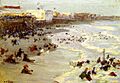
Coney Island, c. 1914, by Edward Henry Potthast

See also
 In Spanish: Coney Island para niños
