Coney Island Creek facts for kids
Quick facts for kids Coney Island Creek |
|
|---|---|

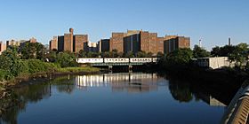
A New York City Subway train crossing the Coney Island Creek
|
|
 |
|
| Country | United States |
| State | New York |
| City | New York City |
| Borough | Brooklyn |
| Physical characteristics | |
| Main source | Shell Road (emerging from storm drain under the road) |
| River mouth | Gravesend Bay |
| Length | 1.8 mi (2.9 km) |
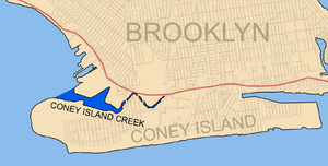
Coney Island Creek is a waterway in Brooklyn, New York City. It's about 1.8 miles (2.9 km) long. This creek is a "tidal inlet," meaning its water level changes with the ocean tides.
Long ago, it was much longer, about 3 miles (4.8 km). It connected Gravesend Bay and Sheepshead Bay. This made Coney Island a true island! But over time, parts of the creek were filled in. This happened in the early to mid-1900s because of land owners and city building projects.
Contents
Where is Coney Island Creek?
Coney Island Creek stretches east from Gravesend Bay. It ends near Shell Road. The creek separates the west side of Coney Island from nearby neighborhoods. These include Gravesend and Bath Beach.
On the south side of the creek, you'll find Coney Island Creek Park and Kaiser Park. Calvert Vaux Park is on the north side. Several bridges cross the creek. These include the Cropsey Avenue and Stillwell Avenue bridges. Two subway lines also cross on special rail bridges. These are the D train and N train lines.
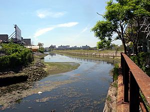
The eastern part of the creek runs next to industrial areas. It also borders land owned by Keyspan, an electricity company. The creek officially ends at Shell Road. Here, a storm sewer pipe empties water from under the road.
How Coney Island Creek Changed Over Time
When Europeans first settled here, Coney Island was a group of small islands. These islands had many waterways between them. Their shapes were always changing. The waterway we now call Coney Island Creek didn't always go all the way across. Part of the land on the west side was a peninsula called Coney Hook.
In 1750, a short canal was dug through the marshy land. This new waterway connected Gravesend Bay to another creek. It allowed ships to travel from Jamaica Bay to New York Harbor. They didn't have to go out into the open ocean. This waterway was first called Gravesend Creek. Later, it became known as Coney Island Creek. Over time, other small creeks and inlets were filled in. This happened naturally and because of building projects. Eventually, only one island, Coney Island, and one creek, Coney Island Creek, remained.
Plans for a Ship Canal
Around the early 1900s, there were plans to make the creek much bigger. They wanted to turn it into the Gravesend Ship Canal. This plan included digging the creek deeper and making it a straight line. They also wanted to fill in all the marshland around it. This would allow the city's street grid to expand right up to the canal.
However, this big plan was never finished. By 1924, local landowners had already filled in part of the creek. More of the creek was filled in during the 1930s. This was done to build the Belt Parkway. Even more land was added in 1962 when the Verrazzano-Narrows Bridge was built.
These projects changed Coney Island Creek a lot. It became an inlet, not a full strait. The eastern and western ends of Coney Island became peninsulas. Today, no part of the creek remains at the far eastern end. That area, Sheepshead Bay, has been dredged and mostly enclosed by walls. The path of the old creek now follows Shore Parkway and other roads.
The Ship Graveyard
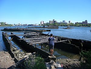
A part of the creek in the northwest is known as a "ship graveyard." This is because many old, abandoned ships can be found there. On the southern shore of the creek, you can see something unusual. It's the remains of a 45-foot (14 m) yellow submarine! This submarine, called the Quester I, was built in the late 1960s. It was made from recycled metal. But it never worked quite right and was left there.
Even though it has been polluted, Coney Island Creek was expected to get some cleanup work done between 2018 and 2020.
 | Calvin Brent |
 | Walter T. Bailey |
 | Martha Cassell Thompson |
 | Alberta Jeannette Cassell |


