
Jamaica Bay facts for kids
Quick facts for kids Jamaica Bay |
|
|---|---|
| Grassy Bay | |

Historic map of Jamaica Bay, with subway lines and major roads
|
|

Jamaica Bay
Location in New York City
|
|
| Location | New York City and Nassau County |
| Coordinates | 40°37′04″N 73°50′33″W / 40.61778°N 73.84250°W |
| Etymology | Lenape |
| Primary outflows | Rockaway Inlet |

Jamaica Bay is a special type of water body called an estuary. An estuary is where a river meets the sea, mixing fresh and salt water. This bay is located on the southern part of Long Island in New York. It's a mix of natural areas and parts created by people.
Jamaica Bay connects to Lower New York Bay through a narrow opening called Rockaway Inlet. It is the westernmost of the coastal lagoons found on Long Island's south shore. Most of the bay is in New York City, split between the boroughs of Brooklyn and Queens. A small part also touches Nassau County.
The bay has many marshy islands. It was even called Grassy Bay until the 1940s. Jamaica Bay is important because it sits where the coastline changes direction. This makes it a key spot for many animals.
Contents
What's in a Name? The Etymology of Jamaica Bay
The name "Jamaica" comes from the nearby town of Jamaica. This town's name comes from Yameco. This was a word for "beaver" in the Lenape language. The Lenape people were Native Americans who lived here long ago.
The Dutch were the first Europeans to write about the area. They spelled the "y" sound with a "j". When the English took over, they kept the "j" spelling. Over time, the "j" sound changed to the harder sound we use today.
Jamaica Bay's Amazing Wildlife and Plants: Ecology
Jamaica Bay is a very important home for fish, wildlife, and plants. It has rich food sources. Many different species live here or stop by during their migrations.
Why is Jamaica Bay So Important for Animals?
The bay's location is perfect for animals moving between the Atlantic Ocean and the Hudson River and Raritan River estuaries. Many types of birds, like shorebirds, raptors, and waterfowl, use the bay. Land birds and various insects also gather here.
The bay is surrounded by a big city. This means the animals gather in the remaining open spaces and water of Jamaica Bay. Over 330 species of animals, including 48 types of fish and 120 types of birds, live here. They can be found seasonally or all year round.
Exploring Jamaica Bay's Features: Geography
.jpg)
Jamaica Bay is a mix of salty and slightly salty water. It's also rich in nutrients, which means it has a lot of plant life. The bay covers about 25,000 acres (100 square kilometers). Its average depth is about 13 feet (4 meters).
The water level changes with the tides by about 4.9 feet (1.5 meters). Water stays in the bay for about three weeks before flowing out. The bay connects to the ocean through Rockaway Inlet. This inlet is about 0.6 miles (1 kilometer) wide and 23 feet (7 meters) deep.
Water Quality in Jamaica Bay
Scientists measure the water in Jamaica Bay regularly.
- The temperature ranges from 34°F to 79°F (1°C to 26°C) throughout the year.
- The saltiness is usually between 20.5 and 26 parts per thousand.
- The amount of dissolved oxygen in the water is between 3.5 and 18.5 milligrams per liter.
- The pH level, which tells us how acidic or basic the water is, is between 6.8 and 9.
However, the bay gets a lot of nutrients and organic matter from sewage treatment plants and runoff. This causes too much growth of tiny plants called phytoplankton. This makes the water cloudy and can lead to low oxygen levels at the bottom of the bay.
How Humans Changed Jamaica Bay
Jamaica Bay is in a very busy area. The land around the bay is mostly cities, homes, and businesses. The bay itself has been changed a lot by human activities.
- People have dredged (dug out) parts of the bay to make navigation channels.
- They have also filled in parts of the bay to create land for building.
- About 49 square kilometers (19 square miles) of the original 65 square kilometers (25 square miles) of wetlands have been filled in. This happened mostly around the edges of the bay.
Two large airports were built on filled land: John F. Kennedy International Airport (JFK Airport) and the historic Floyd Bennett Field.
Islands and Plants in the Bay
The middle of Jamaica Bay has open water and many low-lying islands. These islands have important areas like:
- Salt marshes
- Mudflats that show at low tide
- Uplands, which are higher areas of land
These areas are important for birds that nest in colonies. At low tide, about 350 acres (1.4 square kilometers) of mudflats are exposed. There are also large areas of salt marsh. These marshes are home to different types of cordgrass.
The mudflats are full of food for animals. They have many small creatures that live in the mud and different types of sea lettuce. This rich food attracts many fish, shorebirds, and waterfowl.
Two freshwater ponds were also created in the Jamaica Bay Wildlife Refuge. These ponds attract even more wildlife. Some islands in the bay have different plant communities, like grasslands, shrubs, and even small woodlands.
A Look Back: The History of Jamaica Bay


In the early 1900s, there was a big plan to turn Jamaica Bay into a huge seaport. This plan was never fully finished.
The Grand Seaport Idea
As early as 1886, engineers thought about dredging Rockaway Inlet. They wanted to build a large seaport in Jamaica Bay. But at that time, there wasn't enough shipping traffic to make it worthwhile.
By the early 1900s, New York City's businesses grew a lot. New ideas for the Jamaica Bay seaport came up. In 1910, developers planned to connect Jamaica Bay to the New York State Canal System. This canal would link the Hudson River to the Great Lakes.
The plan was to turn existing creeks into canals for barges. The entire 25 square miles (65 square kilometers) of the bay would be dredged. About 4,200 acres (1,700 hectares) of marshlands would become land for buildings. New communities would be built for port workers. Railroads would also be built to move cargo.
Starting the Project and Why it Stopped
The project began in 1911, even though some people doubted it would work. Engineers worried that shifting sand and tides might make it too hard. By 1912, dredging started to make the bay deep enough for large ships.
By 1918, a lot of dredging was done. The city allowed piers to be built. Only one pier was actually built near Barren Island. It was meant to receive landfill for other planned piers. Another pier was opened at Mill Basin. But when the United States entered World War I, the project was stopped.
Later Plans and Why They Failed
The plans for the seaport were brought back in 1927. There were ideas to connect the docks to the Long Island Rail Road. They also wanted to connect to Staten Island through a planned tunnel. This would allow freight to be sent across the country.
By 1928, Floyd Bennett Field, an airport, was being built on the bay's west side. Supporters of the seaport wanted the docks built at the same time. In 1930, the city approved plans for new railroads and dredging Paerdegat Basin. This would help ships reach Canarsie.
In 1931, the city approved building railroads on both sides of Paerdegat Basin. By this time, the city had spent $10 million and the federal government $2 million on the project. Many important leaders supported it, including Mayor Jimmy Walker.
However, Robert Moses, who was in charge of New York City Parks, did not like the seaport idea. He wanted to build parks and parkways instead. He proposed the Belt Parkway along Jamaica Bay. Under Moses's leadership, the city decided to turn much of the Jamaica Bay area into a city park. In 1949, this plan was approved, ending all seaport projects. Only the dredging of Paerdegat Basin was completed.
Protecting Jamaica Bay: Environmental Conditions

The salt marshes of Jamaica Bay are a great home for migratory birds and other wildlife. Most of the bay's waters and marshes have been protected since 1972. They are part of the Gateway National Recreation Area.
Pollution Challenges
Even though things have improved, pollution is still a problem. The area was once famous for its oysters and had a strong fishing industry. But it has been closed to shellfishing since the early 1900s because of pollution. The marshlands are also shrinking quickly.
As of 2003, about 40 acres (16 hectares) of marshland were being lost each year. Scientists are still trying to figure out why. One idea is that rising sea levels are causing the loss. The National Park Service is trying to rebuild some marsh areas.
Another idea is that too much nitrogen is flowing into the bay. Most of this nitrogen comes from four sewage treatment plants around the bay. High nitrogen levels might cause too much sea lettuce to grow. This can smother other plants. It might also make marsh plants weaker, causing the soil to break apart.
To help with this, the New York City Department of Environmental Protection is working to reduce nitrogen. They are installing new technology to cut nitrogen discharges by thousands of pounds each day.
Who Owns and Protects Jamaica Bay?
Most of the land and water in Jamaica Bay is owned by the United States federal government and New York City.
Protected Areas
- Much of Jamaica Bay is part of the Gateway National Recreation Area. This area is managed by the National Park Service. It includes the 9,100-acre (37 square kilometers) Jamaica Bay Wildlife Refuge. It also includes Breezy Point Tip, Fort Tilden, Jacob Riis Park, and Floyd Bennett Field.
- There are two State Parks in Jamaica Bay: Shirley Chisholm and Bayswater Point.
- Several city parks are also in the bay area. These include Marine Park, Spring Creek Park, and Rockaway Community Park.
- Parts of the wetlands and uplands are part of JFK Airport. The airport is owned by the city and run by the Port Authority of New York and New Jersey. Sometimes, migrating wildlife can even affect airport traffic!
- Small areas around the bay and on the Rockaway Peninsula are still privately owned.
Laws and Designations Protecting the Bay
Jamaica Bay has many special protections:
- It is a protected beach unit under the federal Coastal Barrier Resources Act. This law limits federal money for development there.
- The New York State Natural Heritage Program sees Breezy Point and Fountain Avenue Landfill as very important for biodiversity.
- The New York State Department of State has named Jamaica Bay and Breezy Point as Significant Coastal Fish and Wildlife Habitats.
- The New York Department of Environmental Conservation has called the bay a Critical Environmental Area.
- The New York City Department of City Planning has named Jamaica Bay as one of three special natural waterfront areas.
In 1993, a plan was made to manage the entire watershed of the bay. This plan helps protect and restore habitats and improve water quality. Wetlands in New York are also protected by state and federal laws. These laws help control what can be done in and around the bay.
Images for kids
-
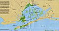
Historic map of Jamaica Bay, with subway lines and major roads
-
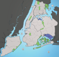
The main waterways surrounding New York City. 1. Hudson River, 2. East River, 3. Long Island Sound, 4. Newark Bay, 5. Upper New York Bay, 6. Lower New York Bay, 7. Jamaica Bay, 8. Atlantic Ocean
-
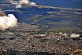
Jamaica Bay from the northwest (2013)
-
Plumb Beach, Brooklyn
-
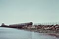
IND Rockaway Line subway train crossing Jamaica Bay, 1973. Photo by Arthur Tress.
-
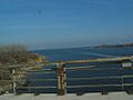
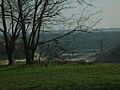
Jamaica Bay seen from Belt Parkway
-
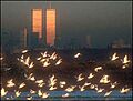
The old World Trade Center seen from Jamaica Bay

See also
 In Spanish: Jamaica Bay para niños
