kids encyclopedia robot

Floyd Bennett Field facts for kids

Kids Encyclopedia Facts
Quick facts for kids
Floyd Bennett Field Historic District
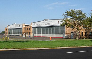
Bennettfield22121.JPG
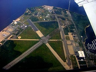
Floyd Bennett Field in 2006
Location Flatbush Avenue, Brooklyn, New York
Built 1928–1930
Architect Department of Docks
Architectural style
NRHP reference No. 80000363
Added to NRHP April 11, 1980

Floyd Bennett Field is a historic airfield in southeast Brooklyn, New York City. It sits along the shore of Jamaica Bay. This airport was once busy with commercial and private planes. Later, it became a naval air station for the military.

Today, Floyd Bennett Field is part of the Gateway National Recreation Area. The National Park Service (NPS) manages it. While planes no longer take off for commercial or military use, the New York City Police Department (NYPD) still uses a part of it for helicopters. Also, one runway is set aside for people who enjoy flying radio-controlled aircraft.

Floyd Bennett Field was built by connecting several small islands, including Barren Island, to Brooklyn. Workers filled the water channels between them with sand from Jamaica Bay. The airport was named after Floyd Bennett. He was a famous pilot who flew over the North Pole. He had dreamed of an airport at Barren Island before he passed away in 1928. Construction on the field began that same year.

The airport officially opened on May 23, 1931. Even though it had excellent facilities, it never became a major commercial airport. Instead, it was mostly used for private flights. In the years between World War I and World War II, many pilots set aviation records flying to or from Floyd Bennett Field.

In the 1930s, the United States Coast Guard and United States Navy began using parts of the airport. When World War II started, Floyd Bennett Field became Naval Air Station New York on June 2, 1941. It was a key center for naval activities during the war. After the war, it remained a naval air station for Navy Reserve training.

The Navy stopped using the field in 1970. The Coast Guard continued helicopter operations until 1998. After the Navy left, many ideas for using Floyd Bennett Field were suggested. However, it was too close to John F. Kennedy International Airport for fixed-wing civilian flights. In 1972, it was decided to make the airport part of the Gateway National Recreation Area. Floyd Bennett Field reopened as a park in 1974.

Many of the airport's oldest buildings are now part of a historic district. They are important examples of early commercial aviation architecture. They also show the significant role the field played in aviation history. Today, Floyd Bennett Field also has natural areas, a campground, and grasslands for visitors to enjoy.

History of Floyd Bennett Field

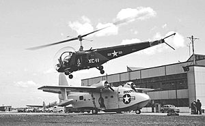
HTL-1 and XJR2F-1 (4622095120)
A Bell HTL-1 taking off near a Grumman Albatross prototype at Floyd Bennett Field (1948)

Why an Airport Was Needed

Floyd Bennett Field was New York City's first airport built by the city itself. It was created because air travel grew a lot after World War I. In the 1920s, air travel was more common in Europe. This was because the United States already had a good railroad system. This meant less need for commercial airplanes.

New York City had many private airfields. So, city leaders did not think a city-owned airport was needed until the late 1920s. In 1925, the city's Board of Estimate suggested building one, but it was turned down.

By 1928, the city really needed an airport. This was clear when Newark Metropolitan Airport opened nearby. Also, famous pilots like Charles Lindbergh made transatlantic flights from the New York area. Most air traffic then was for airmail. The United States Postal Service chose Newark Airport as the main airmail hub for New York City. City officials then decided New York City needed its own airport. They did not want to miss out on the growing aviation industry.

In 1927, a committee looked for good airport locations in the New York area. They suggested a spot in Middle Village, Queens. Their second choice was an existing airstrip on Barren Island in Brooklyn. Clarence D. Chamberlin, a pilot, was chosen to make the final decision.

There was a lot of debate about the best location. Fiorello La Guardia, who later became New York City's mayor, wanted an airport on Governors Island. This island was closer to Manhattan. But his idea was voted down.

Choosing the Airport Site

Chamberlin chose Barren Island for the new airport. This island had been home to a small community and factories. By the 1920s, most people had left. A pilot named Paul Rizzo had already opened a private airstrip there in 1927.

Chamberlin picked Barren Island for several reasons. The city had already spent a lot of money to create a seaport in Jamaica Bay. This meant the land was already being worked on. Barren Island also had no tall buildings nearby. This made it safe for planes. Plus, seaplanes could use Jamaica Bay. Finally, the city already owned the land.

Some airline companies worried about fog at Barren Island. But Chamberlin said there was little fog there. City officials hoped the airport would help develop Jamaica Bay.

Building the Airport

In February 1928, city leaders approved building the airport on Barren Island. They set aside 380 acres for it. They also approved $500,000 for the project. Some people still worried about fog. But Barren Island was already flat, so an airport could be built faster there.

Plans for the airport were made in 1927. The New York City Department of Docks created detailed designs. The airport would handle both airplanes and seaplanes. Seaplanes would have loading docks and hangars on the east side. Airplane hangars and an office building would be on the northwest side. Four runways would be built on the grass field.

By late 1928, a new plan was made. It called for two concrete runways. One would be 3,110 feet long, and the other 4,000 feet long. An administration building, fourteen hangars, and other buildings would be on the west side. The rest of the airport would be a grass field.

The Department of Docks was in charge of building the airport. The first construction contract was given in May 1928. It involved filling and leveling 350 acres of land. Sand from Jamaica Bay was used to connect the islands. This raised the site 16 feet above high tide. This work was finished by May 1929.

To get the highest rating for an airport, planners built runways 200 feet wide. This was twice the minimum width needed. They also built grass fields with many layers of soil for smooth landings.

Barren Island Airport was renamed after pilot Floyd Bennett in October 1928. Bennett had flown over the North Pole in 1926. He died in 1927 during a rescue mission. His wife, Cora, remembered him saying, "Some day, Cora, there will be an airport here." Many things were named after him, including this airport.

Runway Floyd Bennett Field
A concrete runway at Floyd Bennett Field

After the land was ready, two concrete runways were built. The shorter one was Runway 15–33. The longer one, Runway 6–24, was the longest concrete runway in the U.S. at the time. Its thick concrete and wide design helped the airport get a top rating. These modern runways were very advanced for their time.

Plans for the main building and hangars were changed. The number of hangars was cut from fourteen to eight due to lack of money. Construction on these buildings began in late 1929. The main building was built on the west side, near Flatbush Avenue. Four hangars were built to the north and four to the south of it.

Airport Opening

The airport was first dedicated on June 26, 1930. About 25,000 people came to see an air show. Famous pilots like Charles Lindbergh and Jimmy Doolittle were there. But the airport was not fully finished yet. The main building and parking areas were still being built.

Floyd Bennett Field was officially dedicated again on May 23, 1931. By then, the Administration Building was almost done. The United States Navy was also going to use part of the airfield. Another 25,000 people attended this event. Many important people were there, including Lindbergh. They also saw the largest aircraft show in U.S. history at that time, with 597 planes flying over the city.

Commercial Use of the Airport

SOC-4 at Floyd Bennett Field
A U.S. Coast Guard Curtiss SOC-4 Seagull at Floyd Bennett Field

From May 1931 to the end of that year, the airport had over 1,100 commercial flights and 600 military flights. By 1933, Floyd Bennett Field had more flights than Newark Airport. It was the second-busiest airport in the U.S. that year.

However, Floyd Bennett Field was never a big commercial success. It was too far from the rest of New York City. No regular passenger airlines used it until 1934. This was partly because it never got much airmail traffic. Airmail went to Newark Airport instead. In 1937, American Airlines was the only commercial airline to use it regularly, for flights to Boston.

As a private airfield, Floyd Bennett Field attracted many record-breaking pilots. Its modern facilities, lack of obstacles, and location near the Atlantic Ocean made it perfect for long flights. The airport hosted many "firsts" and speed records. It also held air races. Civilians could also take flying lessons there.

The airport was improved over the years. The Works Progress Administration (WPA) and the United States Navy helped with these upgrades. But because it lacked commercial flights, the city started building LaGuardia Field in Queens. This new airport was much closer to Manhattan. Commercial flights stopped at Floyd Bennett Field in 1939 when LaGuardia Field opened. The Navy took over the field completely in 1941.

Getting to the Airport

Marine Parkway Bridge
The Marine Parkway Bridge, opened in 1937, is located south of Floyd Bennett Field

Flatbush Avenue was made wider and straighter to create a more direct route to Manhattan. In 1937, the avenue was extended to the Marine Parkway–Gil Hodges Memorial Bridge. This bridge connected to the Rockaways. A bus route to the subway, the current Q35 route, was also started in 1937. This was meant to make it faster to get to Manhattan. However, the Q35 bus only started stopping at Floyd Bennett Field in 1940.

Floyd Bennett Field's location in outer Brooklyn made it hard to use. There were no direct highways from Manhattan to the airport. Flatbush Avenue was the only direct route, but it was often crowded. The Belt Parkway was built between 1934 and 1940. It provided a faster connection for cars. But commercial vehicles were not allowed on parkways.

Airmail Terminal Ideas

In the 1930s, air travel was expensive. So, airmail made up most of the air traffic. City officials wanted Floyd Bennett Field to be New York City's main air terminal. Mayor LaGuardia pushed for this. He even suggested using flying boats to shuttle passengers to Manhattan.

However, Newark Airport was already set up for commercial traffic. The Post Office Department had chosen Newark as New York City's airmail hub. This meant airlines that carried mail went to Newark. LaGuardia tried to get the Post Office to move airmail operations to Floyd Bennett Field. He argued that Floyd Bennett Field was better equipped.

In 1933, LaGuardia famously refused to get off a plane at Newark Airport. His ticket said the flight went to New York. He demanded the plane fly to Floyd Bennett Field. In 1934, officials asked the Post Office to compare Newark and Floyd Bennett Field.

In 1935, LaGuardia convinced the Post Office to review Floyd Bennett Field. But the review found problems. There was no direct highway or train to Manhattan from Floyd Bennett Field. LaGuardia suggested extending the New York City Subway there. The police even timed trips to both airports. It took 24 minutes to Newark, but 38 minutes to Floyd Bennett Field.

In December 1935, a meeting was held about Floyd Bennett Field. City officials argued that the airport was ready to be an airmail terminal. But in March 1936, the Postmaster General said no. He said moving airmail operations would cause a drop in traffic and profits.

LaGuardia never convinced the Postal Service to move its operations. So, he decided to build LaGuardia Airport in Queens instead. This new airport was much closer to Manhattan. The federal government then divided airmail traffic between Newark and LaGuardia. This showed that Floyd Bennett Field was too far from Manhattan to be a major airmail hub.

Military and Police Use

Floyd Bennett Field - 1 (3477300073)
One of the original hangars

After a nearby naval air station closed in 1930, a hangar at Floyd Bennett Field became Naval Air Reserve Base New York. The Navy Reserve Aviation Unit started using Hangar 1 in April 1931. They leased it for only $1 per year. They later moved to Hangar 5 for more space.

Starting in 1934, the NYPD also used a hangar. They created the world's first police aviation unit in Hangar 4.

In 1935, the United States Coast Guard asked to use part of Floyd Bennett Field. In 1936, about 10 acres were leased to the Coast Guard. This became Coast Guard Air Station Brooklyn (CGAS Brooklyn). A $1 million facility opened in June 1938. The Coast Guard also paid only $1 per year in rent.

The Navy expanded its presence in 1937 and 1939. In June 1940, the government began a third expansion of naval facilities. They built barracks for cadets and took over more hangars. The Navy agreed to rent the expanded area for $8,000 per year. By August 1940, the Navy considered buying the entire airport. The city valued it at $15 million. The city was unsure about selling because the NYPD base was there.

In December 1940, a Navy pilot died in a training crash at the airport. This happened while the Navy and city were discussing the sale.

A security review in 1941 found that it would be hard to manage both military and civilian traffic. The solution was to close the airport to all civilian uses. Soon after, the city suggested an 8-year lease for the Navy.

Airport Improvements

Archives of American Art - Eugene Chodorow - 2023
Mural in progress, c. 1939

Improvements to Floyd Bennett Field continued after it opened. A parking area was finished in May 1931. The Administration Building opened in October. New taxiways and a temporary fence were completed in 1932. The city also installed runway lights and wind-recording equipment to get a top airport rating.

A seaplane base was also built. It had been part of the original plans. Seaplane ramps were built on the east side of the airport. A seaplane base with four hangars was finished in October 1931. It included a long seaplane ramp and a pier. Three seaplane runways were also built.

The Department of Docks planned major upgrades in 1934. The Works Progress Administration (WPA) provided the workers for these upgrades. In 1935, the WPA gave $1.5 million to finish the airport. The federal government contributed $4.7 million in total. The WPA built two extra runways and expanded hangars. They also added more maintenance buildings and a passenger tunnel under the administration building. A brick chimney was torn down to make way for a new runway.

The Navy also expanded its facilities starting in 1938. This was sped up due to World War II in Europe. In 1939, the Navy began building a base for 24 seaplanes. This was to prepare for its "neutrality patrol" activities. The Navy took over Hangars 1 and 2 and a new building. In January 1940, Congress approved the Navy's request to take over 16.4 acres for a new base. The Navy would lease the land for $1 per year.

Floyd Bennett Field During World War II

Six U.S. Coast Guard Sikorsky HNS-1 at Floyd Bennett Field, New Jersey (USA), circa in 1944
The Coast Guard station as seen c. 1944

Military Takes Over

On May 25, 1941, changes to the Navy's expansion plan were announced. All private airlines were told to leave. All remaining residents on Barren Island were moved out to make room for a larger military facility. On May 26, 1941, the airport closed to all civilian uses.

A week later, on June 2, the Navy opened Naval Air Station New York (NAS New York). An air show attracted 30,000 to 50,000 people. Important Navy leaders and New York City Mayor LaGuardia were there.

By fall 1941, the Navy decided Floyd Bennett Field was the best place for its air station. After the attack on Pearl Harbor in December 1941, the Navy wanted to buy the property quickly. The Navy offered $9.75 million, which was less than the city's asking price. On February 9, 1942, the Navy officially took over most of the land. Nine days later, the rest of Floyd Bennett Field became part of NAS New York. The Coast Guard was allowed to stay. But the NYPD aviation unit had to move for the war.

The expanded naval base covered over 1,280 acres. This included the existing airfield, Coast Guard and Navy land, and land from Barren Island residents. The Navy also wanted to buy land west of Flatbush Avenue. But Robert Moses, the Parks Commissioner, stopped this.

Floyd Bennett Field in World War II

NAS New York Floyd Bennet Field NAN1-48
Aerial view of NAS New York in the mid-1940s, showing the original airfield (dark-colored ground) and the new additions (light-colored ground)

The Navy began major upgrades to Floyd Bennett Field in December 1941. They leveled undeveloped land to match the rest of the airport. New and longer runways were built for newer aircraft. All four runways were expanded to 5,000 feet long and 300 feet wide. The Navy also built a seaplane hangar and two seaplane runways. They extended taxiways and roads. Facilities for officers, like barracks and training rooms, were built on the eastern side. All signs of Barren Island's old community were removed.

These upgrades allowed 6,500 people to use the naval base. Most new buildings were designed to be removable. This was in case Floyd Bennett Field became a civilian airfield again after the war.

During the war, NAS New York hosted several Navy aviation units. These included antisubmarine patrol squadrons and transport squadrons. It was a training facility. Navy planes from here also patrolled the Atlantic coast and fought German U-boats. Women in the Navy, called WAVES, worked as air traffic controllers and mechanics. More than 20,000 new aircraft were delivered to NAS New York during the war.

CGAS Brooklyn, the Coast Guard station, also worked with NAS New York. They patrolled New York Harbor and trained soldiers.

After the War

After World War II in 1946, many naval stations were closed or reduced. Floyd Bennett Field became a Naval Air Reserve station. It was the largest Naval Air Reserve base in the U.S. at the time. The Navy removed many temporary buildings. The NYPD Aviation Unit returned to the base.

By 1947, there were ideas to use Floyd Bennett Field for commercial flights again. It would handle extra traffic from LaGuardia Airport. But the Navy and the Port Authority could not agree on costs. Commercial traffic never returned to Floyd Bennett Field.

The Navy allowed the New York Air National Guard and the U.S. Army Air Reserve to use the hangars. The Coast Guard also regained control of CGAS Brooklyn. By 1950, the Navy needed Floyd Bennett Field again for the Cold War and Korean War. Five reserve squadrons from the field were called to active duty. The Navy lengthened three runways and rebuilt roads. They also built a beacon tower and housing for veterans.

Until the early 1970s, NAS New York-Floyd Bennett Field mainly supported Navy and Marine Air Reserve units. It was a training facility for reserve squadrons. Over 3,000 reservists trained there every weekend. The field was busiest on weekends, with up to 300 daily flights. Minor changes were made in the 1960s for jet aircraft.

Closing the Military Base

In the late 1960s, military budgets were tight due to the Vietnam War. The U.S. Navy had to reduce its bases. On March 5, 1970, the government announced the Navy would leave Floyd Bennett Field. Mayor John V. Lindsay asked to convert it into a commercial airport. Governor Nelson Rockefeller proposed a $1.4 billion development with homes and shops.

On April 4, 1970, the Navy began closing NAS New York. Its squadrons and personnel moved to other naval air stations. A small Navy Reserve unit remained until 1983.

The debate over Floyd Bennett Field's future continued. President Richard Nixon supported turning it into a national park. This idea had been suggested earlier. In May, the president started the process for Congressional approval. The state government objected, saying nearby Marine Park was not fully used. Meanwhile, only Coast Guard and NYPD helicopters used Floyd Bennett Field.

Floyd Bennett Field as a National Park

Floyd Bennett Field - 3 (3477306787)
National Park Service entrance sign

Becoming a Park

The United States House of Representatives approved creating Gateway National Recreation Area in September 1972. Most of Floyd Bennett Field was given to the National Park Service (NPS) for this new park. The House also rejected the state's plan for housing. The recreation area officially opened on October 27, 1972. Floyd Bennett Field became the headquarters for Gateway's Jamaica Bay unit.

The Coast Guard gained ownership of CGAS Brooklyn and expanded it. The NYPD's aviation unit continued to lease space in Hangar 3. The park opened in 1974. The NPS focused on promoting fun activities. Due to lack of money, much of the field returned to its natural state. The NPS added tents for campgrounds. They also planted pine trees to create "Ecology Village."

By 1979, the NPS divided Floyd Bennett Field into three zones. The "Natural Area" was for nature. The "Developed Area" (hangars and main building) was for preserving buildings. The "Administrative Area" was for the Coast Guard, NPS, and NYPD. The former administration building became the William Fitts Ryan Visitor Center.

In its early years as a park, Floyd Bennett Field had few visitors. Many people did not even know it was a park.

1990s Changes

In 1988, the NPS looked for private companies to develop parts of Floyd Bennett Field. Many ideas, like housing or an amusement park, were rejected. By the 1990s, the NPS sought commercial tenants for the old hangars. Around 1996, funds were given to improve parking at the Ryan Center.

In 1997, the 6th Communication Battalion of the United States Marine Corps Reserve moved to the south side of the field. In 1998, CGAS Brooklyn closed. Most of the Coast Guard land went to the National Park Service. The NYPD moved its aviation operations to the former Coast Guard facilities. The New York City Department of Sanitation (DSNY) also started using the runways for truck-driving practice.

In 1999, a 119-foot tall Doppler radar tower was placed at Floyd Bennett Field. It was for nearby JFK Airport to detect wind shears. The $6 million tower was controversial because residents thought it was ugly. The Interior Department allowed it in the NYPD heliport area, which had "no recreational value."

21st Century Developments

In 2001, the NPS asked for proposals for the hangars. Two bids included an ice skating rink. A company called Aviator won. In 2006, hangars 1 through 4 were turned into the Aviator Sports and Events Center. This is a large sports and entertainment complex. The site of hangars 9 and 10 also became part of the Aviator Complex.

Since the Aviator Sports Complex opened, there have been other plans for Floyd Bennett Field. These include ideas like an Olympic-size swimming pool. The Ryan Center was also restored to its original look. The renovation was finished in May 2012.

What Floyd Bennett Field Looks Like Today

Floyd Bennett Field
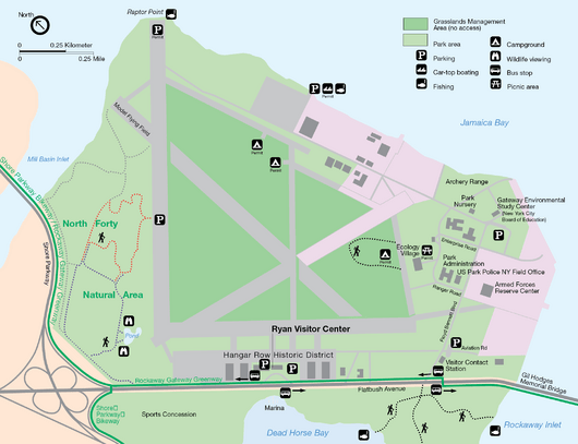
1998 map of Floyd Bennett Field from the National Park Service

Floyd Bennett Field covers over 1,000 acres in southeast Brooklyn. It is about 20 miles from Midtown Manhattan.

The main part of the field is east of Flatbush Avenue. This area has the airport's eight hangars, the administration building, and five runways. These buildings are mostly preserved as they were originally. Two runways and two taxiways surround a large field. The North Forty Natural Area is north of this field. The eastern side is next to Mill Basin Inlet and Jamaica Bay.

The Gateway Development Plan of 1979 divided the field into three areas. The "Natural Area" in the north is for protecting nature. The "Developed Area" in the west is for preserving and reusing buildings. The "Administrative Area" in the south is used by the Coast Guard, NPS, and NYPD.

West of Flatbush Avenue, the National Park Service manages a golf driving range and marina. This area is next to Dead Horse Bay.

Floyd Bennett Field also has public camping with 46 campsites. A "Grassland Management Area" in the center is closed to the public. An "Ecology Village" at the south end hosts classes for middle-school students. South of the field, there is an archery range, softball and baseball fields, and a racetrack for remote-controlled cars. The New York City Police Department (NYPD), New York City Department of Sanitation (DSNY), and United States Park Police (USPP) all have their own areas on the eastern side.

The airport's old code was NOP. Now, the NYPD heliport uses the code NY22.

The Administration Building (Ryan Center)

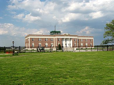
Floyd Bennet Admin jeh
The former Administration Building, which now serves as the Ryan Visitor Center

The administration building is now called the William Fitts Ryan Visitor Center, or Ryan Center. It is a two-story building with a four-story observation tower. Ryan Center is the main entrance to Floyd Bennett Field. It used to be the airport's passenger terminal and office building. Visitors can explore parts of it, including the old control tower.

The building is 185 feet long and 72 feet wide. It is made of red and black brick. It has a classic, formal look, similar to train stations from the early 1900s. This design was meant to make passengers feel comfortable. Flying was still new to many people back then.

The front of the building, facing Flatbush Avenue, has three arched entrances. These entrances have Ionic columns. A winged globe, part of the original design, was once at the corner. Clocks hung above the doorways. During later renovations, passenger ramps were replaced with four tunnels. These tunnels allowed people to cross under the runways.

On the back side, the center part is shaped like an octagon. This section holds the four-story observation tower. The top floor was the control tower. Balconies are on the first floor. Bronze letters spelling "Naval Air Station" and "Floyd Bennett Field" are above the entrance. A one-story addition was built on the north side in 1941.

The inside of the building has an Art Deco style. It originally had a restaurant, cafeteria, post office, and dorms. It also had rooms for the National Weather Service. The interior is simply decorated with some marble panels.

A parking area was added in 1932. A landscaped garden was planted in front of the building from 1935 to 1936. This included shrubs and flower beds. During World War II, the parking lot was fenced off. Visitors had to use a different entrance.

A large community garden is located south of Ryan Center. It has about 480 plots and is the biggest community garden in New York City.

Airport Hangars

Floyd Bennett hangers jeh
Hangars 7 and 8

Hangars Along Hangar Row

The original hangars are called "Hangar Row." They are numbered 1–8. Hangars 1–4 are north of the administration building, and 5–8 are south. They all look very similar. They have buff-and-brown brick walls and steel frames. Each hangar has a two-story service wing with offices and shops. The letters on the hangars originally spelled "City of New York" and "Floyd Bennett Field."

Each pair of hangars is connected by a brick building. These connecting buildings were added later, during the WPA renovations. Each original hangar had a large interior space, 120 by 140 feet, with 22-foot tall doors. They were built with many bricks and tons of steel.

By 1942–1943, the Navy built Hangars 9 and 10. These were wood-frame buildings north of Hangars 1 and 2.

In 2006, Hangars 5–8 were combined to create the Aviator Sports and Events Center. This $38 million complex has ice skating rinks in two hangars. The other two hangars have a field house, a gymnastics and dance complex, and a fitness center. The Aviator Complex also has restaurants and stores. Two turf football fields were built outside, where Hangars 9 and 10 used to be.

Hangars Along the Coast

Hall PH and Stinson Reliant at CGAS Brooklyn 1938
Coast Guard hangar, located along the Jamaica Bay coast

In 1937, the Coast Guard built a hangar on the Jamaica Bay coast. It was built in the Moderne style with white walls and a curved roof. It had a large concrete area outside. The Coast Guard used this hangar until about 1998.

In 1939, the Navy began building Hangar A along the Jamaica Bay coast. This large steel-framed hangar was for the Navy's flying boats. It was 250 by 400 feet, much bigger than the other hangars. It had a simple design. A seaplane ramp and pier were also built with it.

In 1942, Hangar B was built. It was a copy of Hangar A. Both hangars were later changed to fit jet airplanes. Hangar A was torn down in 1998. Volunteers now keep a collection of historic aircraft in Hangar B.

Other Buildings

At first, all maintenance was done in the Administration Building. Later, separate buildings were added for these tasks. Many were built during the WPA renovation from 1934 to 1938. These buildings looked similar to the original hangars. They included a service building, generator buildings, a pump house, and a garage.

During World War II, the Navy built several wood-frame buildings south of the hangars. They also built a munitions storage area. Most of these original buildings are still there.

The Navy built two barracks areas for soldiers during World War II. The main barracks had buildings for officers and enlisted personnel, a mess hall, and a recreation building. These main barracks were torn down after the war. They were replaced with more permanent barracks for veterans. In the 1960s, the Navy built a trailer park and a school building. In 1970, a new barracks, Tylunas Hall, was built. It is now used by the DSNY.

The Coast Guard also built barracks in 1943. A new concrete barracks was finished in 1979. In 1979, the Coast Guard built a swimming pool where its old barracks used to be.

Runways

Floyd Bennett Field from the North
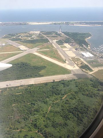
Aerial view of Floyd Bennett Field's runways as seen during departure from John F. Kennedy International Airport

Floyd Bennett Field has five concrete runways. Two were built in 1929. Two more were added during the WPA renovation in 1937–1938. Another runway was built in 1942 when the Navy took over. The runways are no longer used for air traffic. Today, visitors use them for flying radio-controlled aircraft, land sailing, and cycling. One area is specifically for flying model airplanes.

The two original runways were 100 feet wide. Runway 15–33 was 3,100 feet long and was extended to 3,500 feet in 1936. It ran next to the original hangars. The longer Runway 6–24 was 4,000 feet long. After the WPA renovations, Runway 15–33 had green lights for bad-weather landings.

The two runways built in 1937–1938 were 150 feet wide. Runway 1–19 was 3,500 feet long. Runway 12–30 was 3,200 feet long. A brick chimney was removed because it was in the way of Runway 12. The NYPD Aviation Unit still uses a section of Runway 12–30 for helicopters.

A new Runway 6–24 was built in 1942. This runway was 5,000 feet long and 300 feet wide. It ran parallel to the old Runway 6–24, which became taxiways. Runways 1–19 and 12–30 were also lengthened to 5,000 feet.

Around 1952, Runway 1–19 was expanded again to 7,000 feet. Runway 12–30 was expanded to 5,500 feet. The new Runway 6–24 was lengthened to 6,000 feet. In 1965, Runway 15–33 was changed to a taxiway.

There were also three seaplane runways on the eastern coast. They were numbered 12–30, 18–36, and 7–25. There was also a turning basin where two of the seaplane runways met.

The Field Itself

The Goldenrod and Tamarack Campgrounds are near Hangar B. This is the only legal campground in New York City. The 46 campsites are simple, with only portable toilets and no electricity.

The General Management Plan of 1979 also called for maintaining the grasslands. The Grasslands Restoration And Management Project (GRAMP) works to protect these grasslands. This area is about 140 acres and is closed to the public. Some runways were also planted with grass.

The triangle-shaped Ecology Village is at the south end of the field. It has hundreds of pine trees planted around 1974. The Ecology Village is an environmental education program. Students from fourth to eighth grades can camp there overnight. In the summer, non-profit groups can use the campgrounds.

The North Forty Natural Area is on the northern side of the airport. It used to be a Navy storage area. It has a hiking trail, a woodland, and a sandy area. A 2-acre freshwater pond, built around 1980, is also in this area.

The Coastline Area

The former Coast Guard base is along the eastern coast of Floyd Bennett Field. It originally had a hangar, garage, radio station, barracks, and runways. The former Navy base is also here. It includes Hangars A and B, barracks, two seaplane ramps, and maintenance buildings.

The Navy built a boat basin and recreation area along the coast during World War II. After the war, they updated the area, adding a running track.

What is Floyd Bennett Field Used for Now?

Floyd Bennett Field aerial from north 01 - white balanced (9454476975)
Floyd Bennett Field from the air, 2013

The New York City Police Department (NYPD) has units at the former airfield. Their aviation base is in the old Coast Guard area. It is also the headquarters for the New York City Police Department Emergency Service Unit. The Driver Training Unit uses a section of the old runway to teach officers how to drive different vehicles.

The New York City Department of Sanitation Training Center is in Tylunas Hall. They also use part of the old runway for driver training.

The United States Park Police (USPP) operates from a station here. They provide police coverage for the New York areas of the Gateway National Recreation Area. The National Park Service's Jamaica Bay Unit Headquarters is also located in one of the buildings.

The Civil Air Patrol's Floyd Bennett Composite Squadron meets regularly at the airfield. The southern part of Floyd Bennett Field is also home to the 6th Communication Battalion of the United States Marine Corps Reserve.

Famous Flights from Floyd Bennett Field

Floyd Bennett Field was a popular spot for famous pilots in the 1930s. It had great conditions: good weather, open space, modern facilities, and not much commercial traffic. Because of this, many record-breaking flights started or ended here. These included 26 flights around the world or across oceans, and 10 flights across the United States.

On July 28–30, 1931, Russell Norton Boardman and John Louis Polando flew a plane called Cape Cod to Istanbul. They set a straight-line distance record of 5,011.8 miles. The runway at Floyd Bennett Field was only 5,000 feet long. So, they had to remove a fence and clear a parking lot to add more length for takeoff. Phone and electric companies even took down poles along Flatbush Avenue to help.

Just seventeen minutes after they left, Hugh Herndon Jr. and Clyde Pangborn flew another plane, Miss Veedol, to Wales. They later flew around the world, landing back at Floyd Bennett Field on October 17, 1931.

Many notable flights across the United States also started or ended at Floyd Bennett Field between 1931 and 1939:

  • On August 29, 1932, James G. Haizlip flew from Floyd Bennett Field to Los Angeles in 10 hours and 19 minutes. He set a new record for flying across the country.
  • On November 14, 1932, Colonel Roscoe Turner flew from Floyd Bennett Field to Burbank, California, setting a new East–West record.
  • On June 2, 1933, Lieutenant Commander Frank Hawks flew from Los Angeles to Floyd Bennett Field in 13 hours and 26 minutes. He set a new non-stop West–East record.
  • On July 1, 1933, Colonel Turner flew from Floyd Bennett Field to Los Angeles, setting another East–West record. He later broke his own record.
  • On January 15, 1935, Major James H. Doolittle flew non-stop from Los Angeles to Floyd Bennett Field in 11 hours and 59 minutes. This was a record for a passenger plane.
  • On July 11, 1935, Laura Ingalls flew from Floyd Bennett Field to Burbank, California, setting an East–West record for women. She also set a new record on her return trip.
  • On September 4, 1936, Louise Thaden and Blanche Noyes flew from Floyd Bennett Field to Los Angeles. They set an East–West speed record.
  • On December 3, 1938, Jacqueline Cochrane flew from Burbank, California, to Floyd Bennett Field. She set the women's West–East record.

Famous pilot Wiley Post used the field twice for his record-breaking flights around the world. He also developed new technology there, like the Sperry autopilot. Other famous female pilots like Jackie Cochran, Laura Ingalls, and Amelia Earhart also broke records at this airfield. Colonel Roscoe Turner was a frequent visitor too.

From July 10 to 14, 1938, Howard Hughes and his crew used Floyd Bennett Field to start and finish their record-setting flight around the world. They completed it in just over three days. A crowd of 25,000 people greeted his return.

Floyd Bennett Field's most famous flight was probably by Douglas "Wrong Way" Corrigan. He was repeatedly told he could not fly non-stop to Ireland. But he "accidentally" crossed the Atlantic anyway. He claimed he had trouble with his compass. On July 17–18, 1938, Corrigan flew non-stop from Floyd Bennett Field to Dublin in 28 hours and 13 minutes. Americans loved his "accident" during the Great Depression. He even got a ticker-tape parade in Manhattan when he returned.

Other important flights at Floyd Bennett Field included:

  • June 3, 1932 – Stanislaus F. Hausner tried to fly across the Atlantic to Warsaw, Poland. He had to land at sea but was rescued.
  • July 5–6, 1932 – James Mattern and Bennett Griffin flew from Floyd Bennett Field to Berlin. This was part of a failed round-the-world attempt.
  • August 23 – September 11, 1932 – Lt. Colonel George R. Hutchinson and his family flew a seaplane from Floyd Bennett Field. They had to land off the coast of Greenland and were rescued.
  • September 13, 1932 – William Ulbrich and his passengers flew from Floyd Bennett Field and were lost at sea.
  • June 11–12, 1933 – Captain J. Errol Boyd and his crew flew from Floyd Bennett Field to Haiti.
  • June 15, 1933 – James J. Mattern flew eastward from Floyd Bennett Field. He had to land in Siberia.
  • July 1 – August 12, 1933 – Italian Air Force General Italo Balbo led a group of 23 seaplanes from Italy to Chicago. They stopped at Floyd Bennett Field for six days on their way back to Rome.
  • July 15–17, 1933 – Captain Steponas Darius and Stasys Girėnas flew from Floyd Bennett Field. They crashed in Germany while trying to fly to Lithuania.
  • July 15–22, 1933 – Wiley Post flew his plane, Winnie Mae, around the world in 7 days. He was the first to fly around the world alone. A crowd of 50,000 people watched him arrive.
  • August 5–7, 1933 – Lt. Maurice Rossi and Paul Codos flew from Floyd Bennett Field to Syria. They set a distance record.
  • September 2, 1933 – Francesco de Pinedo died in a crash during takeoff from Floyd Bennett Field.
  • February 28 – April 25, 1934 – Laura H. Ingalls flew from New York to South America. She traveled alone over the Andes mountains. She returned to Floyd Bennett Field after her flight.
  • May 14–15, 1934 – George R. Pond and Cesare Sabelli tried to fly non-stop from Floyd Bennett Field to Rome. They had to land in Ireland.
  • May 27–28, 1934 – Lt. Maurice Rossi and Paul Codos flew non-stop from Paris, France, to Floyd Bennett Field. This was the second non-stop flight from Europe to America.
  • April 30, 1935 – D. W. Tomlinson flew non-stop from Burbank, California, to Floyd Bennett Field. He set a new record.
  • May 16–18, 1935 – D. W. Tomlinson and J. S. Bartles set many speed records at Floyd Bennett Field. They showed how efficient transport planes were becoming.
  • July 18 – August 16, 1935 – Thor Solberg flew from Floyd Bennett Field to Norway.
  • September 21–22, 1935 – Felix Waitkus flew from Floyd Bennett Field to Ireland. He was supposed to go to Lithuania.
  • April 21, 1936 – Howard Hughes flew from Miami to Floyd Bennett Field. He set an intercity speed record.
  • September 2–3, 1936 – Harry Richman and Richard T. Merrill flew from Floyd Bennett Field to Wales. They were trying to fly round-trip to London.
  • October 6–7, 1936 – Kurt Bjorkvall tried to fly from Floyd Bennett Field to Sweden. His plane crashed near Ireland.
  • October 28–30, 1936 – Captain James A. Mollison flew from Floyd Bennett Field to London, England. He was the first pilot to fly non-stop to London.
  • December 14, 1936 – Major Alexander de Seversky flew from Floyd Bennett Field to Miami, Florida. He set a new speed record.
  • May 9–14, 1937 – Richard T. Merrill flew from Floyd Bennett Field to London. He later flew back to Floyd Bennett Field carrying photos of a royal coronation.
  • August 10–14, 1938 – A German crew flew a Focke-Wulf plane non-stop from Berlin to Floyd Bennett Field. They set a record time. They then flew back to Berlin, setting another record.
  • May 24, 1939 – Francisco Sarabia flew from Mexico City to Floyd Bennett Field. He beat Amelia Earhart's record time. Sadly, Sarabia died in a crash shortly after.

The last record-breaking flight at Floyd Bennett Field was on July 16, 1957. Then-Major John H. Glenn, Jr. (who later became an astronaut) flew an F8U-1P Crusader jet from California to Floyd Bennett Field. He set a new record for flying across America in 3 hours and 23 minutes. This was the first time a plane flew across the country at supersonic speed.

How to Get to Floyd Bennett Field

Public Transportation

Q35 at Floyd Bennett Field 02
A Q35 bus near Floyd Bennett Field

The Q35 local bus serves Floyd Bennett Field on Flatbush Avenue. The Q35 travels between Rockaway Park, Queens, and Flatbush, Brooklyn. It crosses the Marine Parkway–Gil Hodges Memorial Bridge. The Q35 has three stops near Floyd Bennett Field. These are near the Brooklyn Golf Center, the Ryan Visitor Center, and Aviation Road.

The Q35 connects to two New York City Subway stations. One is in the Rockaways, at Rockaway Park–Beach 116th Street. The other is in Brooklyn, at Flatbush Avenue–Brooklyn College. There were plans in the 1930s to extend the subway directly to Floyd Bennett Field, but they were never built.

Driving Access

You can reach Floyd Bennett Field by car using the Belt Parkway. This parkway runs along the south shore of Brooklyn and Queens. You can exit at Flatbush Avenue in Marine Park, Brooklyn. To the south, Flatbush Avenue connects to Jacob Riis Park via the Marine Parkway Bridge.

Images for kids

kids search engine
Floyd Bennett Field Facts for Kids. Kiddle Encyclopedia.