
Jacob Riis Park facts for kids
Quick facts for kids Jacob Riis Park |
|
|---|---|
 |
|
| Type | Public park |
| Location | Queens, New York City, New York, United States |
| Area | 262 acres (106 ha) |
| Created | 1937 |
| Operated by | National Park Service |
| Status | Open all year |
| Public transit access | Bus: QM16, Q35 |
Jacob Riis Park, also known as Riis Park, is a beautiful seaside park located on the Rockaway Peninsula in Queens, New York City. It's a popular spot for families and friends to enjoy the Atlantic Ocean beach. The park is famous for its wide sandy shores and cool Art Deco buildings. It's part of the Gateway National Recreation Area and is looked after by the National Park Service (NPS).
Contents
Park's Name History
The park was first called Seaside Park. Later, it was named Telawana Park after Culluloo Telewana. He was believed to be the last member of the local Lenape tribe. In 1914, the park was renamed to honor Jacob Riis. He was a famous journalist and photographer in New York City. Riis showed everyone what life was like for people who were struggling.
A Look Back at Jacob Riis Park's History
How the Park Land Formed
Long ago, in the early 1800s, the area where Jacob Riis Park now stands was mostly underwater. Over time, sand naturally built up from the ocean's tides. This process made the peninsula grow westward. By the early 1900s, the land had reached its current size.
Early Ideas for a Park
In the late 1800s, some businessmen wanted to build a fancy park and amusement area here. They planned hotels and even a horse racing track. They hired Frederick Law Olmsted, who designed Central Park, to survey the land. But their plans didn't work out, and the hotels were eventually taken down.
Becoming a City Park
The City of New York decided it needed a large beach park. In 1904, with support from Jacob Riis, the city started planning for an oceanside park. After some discussions, the city bought the land in 1912. It was first called Telawana Park. After Jacob Riis passed away in 1914, it was renamed Jacob Riis Park in his honor. A hospital for children, Neponsit Beach Hospital, also opened on part of the park's land in 1915.
A Military Air Station
During World War I in 1917, the park's site was used by the United States Navy. They created Naval Air Station Rockaway, one of the first naval air stations in the country. In 1919, a historic event happened here: the first transatlantic flight took off from this very spot. The Navy later moved its operations in 1930.
Building the Park We Know Today
In the 1930s, a lot of work began to turn Riis Park into a fantastic public beach. A large Art Deco-style bathhouse was built in 1932. This was a place where people could change their clothes. But the park really took shape under Robert Moses, who was the New York City Parks Commissioner. He wanted Riis Park to be a wonderful getaway for everyone in New York City, just like Jones Beach State Park.
Between 1936 and 1937, many new things were added. This included a huge parking lot for thousands of cars, a central walking area called the mall, and a long boardwalk. The Marine Parkway–Gil Hodges Memorial Bridge was also built. This made it much easier for people to drive to the park.
Changes and Challenges Over Time
After many years, in 1974, Jacob Riis Park became part of the Gateway National Recreation Area. It was then managed by the National Park Service. This helped bring new life to the park with renovations and improvements. The park's historic buildings were recognized as important. They were listed on the National Register of Historic Places in 1981.
Sometimes, the park faced challenges like keeping the water clean. There were also efforts to ensure all visitors followed park rules regarding appropriate beach attire. Discussions about adding new attractions like a water park also happened. However, these plans were eventually changed due to community feedback.
In October 2012, Hurricane Sandy caused damage to the park. It pushed sand onto the land and flooded the bathhouse. The park's large parking lot was even used to temporarily store debris from the storm. This helped with cleanup efforts across the peninsula. But the park quickly reopened in May 2013, showing its strength and importance to the community.
A natural gas pipeline was built through parts of the park in 2015. This helped provide energy to the city. Also, the old Neponsit Beach Hospital, which was on park land, was taken down in early 2023. A memorial for a local artist named Ms. Colombia, who loved the beach, is located near the former hospital site.
Exploring Jacob Riis Park
Jacob Riis Park is located at the western end of the Rockaway Peninsula. It stretches for about 1 mile (1.6 km) from east to west. The park has beautiful beaches along the Atlantic Ocean to the south. The Jamaica Bay shore is to the north.
Park Features for Fun
The Historic Bathhouse
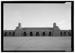
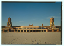
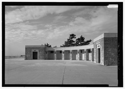
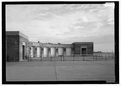
The park's main bathhouse is a large, impressive building. It was first built in 1932 with a unique Moorish and Byzantine style. Later, in 1936-1937, it was updated with Art Deco elements, giving it a modern look. The bathhouse has an Entry Pavilion at the front and a Beach Pavilion facing the ocean. It used to have many changing rooms and showers. Now, much of the space is used for visitor facilities and park services.
The Central Mall
The Central Mall is a wide, open area that runs from north to south through the park. It was designed so that you can even see the Empire State Building far away in Manhattan from here! At the south end of the mall are two semi-circle shaped buildings. These buildings, built in the Art Deco style, hold offices, public restrooms, and concession stands where you can grab a snack. A bronze bust of Jacob Riis, honoring his legacy, was installed here in 2010.
The Boardwalk
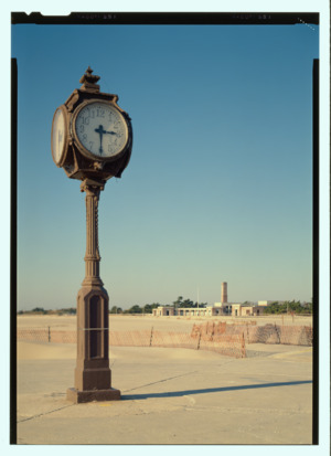
A long boardwalk stretches along the entire beach. It separates the sand from the other park areas. It's a great place for walking and enjoying the ocean views. The boardwalk was mostly built in the 1930s and was later updated to concrete. You'll also find the historic Wise Clock on the boardwalk, which has been ticking since 1941!
The Big Parking Lot
The park has a very large parking lot. It is big enough for thousands of cars. It was once considered the largest paved parking lot in the world! This lot helps many visitors access the park. It is especially useful for those driving in from other parts of New York City.
More Fun Activities
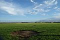
Jacob Riis Park offers lots of other activities. There's an 18-hole pitch and putt golf course at the west end of the park. You can also find playgrounds and sports fields for baseball, basketball, handball, and shuffleboard. There are even open grassy areas perfect for picnicking and grilling with family and friends. A New York City Fire Department station is also located at the park's northwest corner.
The Beaches of Riis Park

The park's Atlantic Ocean coastline is divided into 14 sections, called "bays." They are numbered from east to west. These bays are separated by structures that help keep the sand stable. The main beach has a unique crescent shape. The beaches are a fantastic place to swim, sunbathe, and play in the sand.
Getting to Jacob Riis Park
By Public Transport
You can reach Jacob Riis Park by bus! The Q35 bus travels between Rockaway Park and Brooklyn. It stops right at the Riis Park bathhouse during the summer. The QM16 express bus also comes to the park from Manhattan.
If you prefer the subway, the closest station is Rockaway Park–Beach 116th Street. This station connects to the Q35 bus. You can also take the NYC Ferry to Rockaway Park. A free shuttle bus will then take you to Riis Park.
By Car
If you're driving, the Belt Parkway connects to the Marine Parkway–Gil Hodges Memorial Bridge. This bridge leads directly to Riis Park. You can also get there via Cross Bay Boulevard from central Queens. The park has a large parking lot. Remember there's a fee to park during the summer months.
Images for kids
-
The former Neponsit Beach Hospital, before its demolition.
-
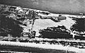
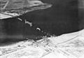
An aerial view of the Naval Air Station Rockaway in 1917.
-
A plaque commemorating the bathhouse completion.
-
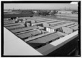
Changing rooms in the bathhouse courtyard, now removed.
-
Construction of the Marine Parkway Bridge and Riis Park in 1937.
-
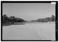
Looking north from the central mall towards the Empire State Building.
-
Baseball fields built on the former Neponsit Beach Hospital land.
-
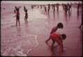
Beach-goers at Riis Park in 1974.
-
Looking at the Riis Park parking lot in 2012.
-
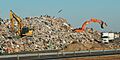
The Riis Park parking lot used for debris after Hurricane Sandy.
-
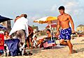
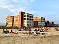
People enjoying the beach over Labor Day weekend in August 2013.
-
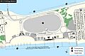
A map of Jacob Riis Park.
-
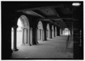
Inside the front arcade of the bathhouse.
-
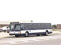
A retired bus parked in front of Riis Park.
-
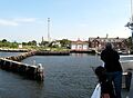
The Riis Landing ferry stop on the Jamaica Bay shore.
-
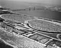
An aerial view of Riis Park and the Marine Parkway Bridge in 1956.


.jpg)
_019.jpg)
.jpg)


.jpg)
