
Mill Basin, Brooklyn facts for kids
Quick facts for kids
Mill Basin
|
|
|---|---|
|
Neighborhood of Brooklyn
|
|

The neighborhood and waterway of Mill Basin, seen from the Belt Parkway drawbridge
|
|
| Etymology: A grist mill built by Dutch settlers in the 17th century | |
| Country | |
| State | |
| City | |
| Borough | Brooklyn |
| Community District | Brooklyn 18 |
| Population
(2010)
|
|
| • Total | 45,231 |
| Neighborhood tabulation area; includes Mill Basin, Bergen Beach, Marine Park, and Flatlands | |
| Ethnicity | |
| • White | 73.8% |
| • Black | 10.9% |
| • Hispanic | 7.9% |
| • Asian | 5.6% |
| • Other | 1.8% |
| ZIP Code |
11234
|
| Area codes | 718, 347, 929, and 917 |
Mill Basin is a neighborhood in southeastern Brooklyn, New York City. It sits on a peninsula next to Jamaica Bay. The area is bordered by Avenue U to the northwest and the Mill Basin waterway on its other sides.
Mill Basin is close to other neighborhoods like Bergen Beach and Flatlands. It also includes a smaller area called Old Mill Basin, located north of Avenue U.
Long ago, Mill Basin was an island called Mill Island. In the 1600s, a mill was built there. Over time, the area changed from a rural place with oyster fishing to a more industrial and then residential area. Today, Mill Basin is known for some of New York City's most beautiful homes. It also has shops, businesses, and the large Kings Plaza shopping mall.
Mill Basin is part of Brooklyn Community Board 18. Its main ZIP Code is 11234. The New York City Police Department's 63rd Precinct patrols the area.
Contents
- What is Mill Basin's Geography Like?
- How Did Mill Basin Get Its Start?
- What is the Mill Basin Community Like?
- Who Lives in Mill Basin?
- What Can You Do for Fun in Mill Basin?
- What About Schools and Libraries in Mill Basin?
- How Do People Get Around Mill Basin?
- What About Religion in Mill Basin?
- Images for kids
What is Mill Basin's Geography Like?
Mill Basin was once an island in Jamaica Bay near Canarsie. Most of the island was low-lying meadows, but a small part was higher land. The area's landscape has changed a lot over time.
In the late 1890s, a wall was built along Mill Island's shore. This wall later connected Mill Island to nearby Bergen Beach. This created a continuous raised path that was used for the Belt Parkway. Some parts of Mill Basin remained wetlands until the late 1900s.
A stream once flowed where Avenue U is now, separating Mill Island from the mainland. Maps show that Mill Island was connected to the mainland by 1926. However, modern city maps still refer to "Mill Island."
The New York Times described Mill Basin as a "mitten-shaped peninsula." It is surrounded by the Mill Basin waterway on three sides. The neighborhood is mainly for one- or two-family homes. There are also small shopping areas and waterfront spots for fun. The area between Avenue U and the waterway is used for heavy industry. Old Mill Basin is the part of the neighborhood north of Avenue U.
How Did Mill Basin Get Its Start?
Early Settlers and the Mill
The Lenape Native Americans first lived in this area. They called the land "Equendito," which likely means "Broken Lands." In 1624, the Dutch Republic started the colony of New Netherland, which included much of New York City.
In 1636, Dutch settlers moved from Manhattan and founded a town called Achtervelt. They bought a large area of land around Jamaica Bay. The local Native American leaders signed agreements with the Dutch, giving up much of their land, including Mill Island.
Mill Island was sold to John Tilton Jr. and Samuel Spicer in 1664. Later, in the 1660s or 1670s, a settler named Elbert Elbertse leased Mill Island.
In 1675, Jans Martense Schenck owned the land. He built a house there, which is thought to be one of the oldest houses in New York City. Schenck also built a pier to load and unload goods. A tide mill was built on the land around 1660 to 1675. This mill used the ocean's tides to grind grain.

When Schenck passed away in 1689, his son Martin took over the estate. The mill was later inherited by Nicholas Schenck. In 1784, the property was sold to Joris Martense. By 1794, the mill was known as "the mill of Martensen."
The property, including the mill, farm, and house, was later passed down through the Crooke family. In 1818, Margaret Crooke inherited the land. After this, the mill was called "Crooke's Mill." The name "Mill Island" likely started being used in the late 1800s. Before that, people just called it "the mill."
What is the Mill Basin Community Like?
The New York Times describes Mill Basin as a suburban area with water almost all around it. Many people who live here own boats. Mill Basin is part of Brooklyn Community Board 18. This board also includes areas like Canarsie and Marine Park.
Mill Basin has some of New York City's most expensive houses. Most homes were built in the late 1900s. Many waterfront houses have docks, great water views, and high ceilings. Homes here often cost millions of dollars. In 2017, a house that needed updates could cost around $850,000. Waterfront homes started at $1.6 million. Some houses even have elevators or large garages.
In Old Mill Basin, which is north of Avenue U, you'll find mostly detached houses. The houses on the Mill Island part of Mill Basin are more expensive. The cheapest homes are in the northwest corner.
Some old lead factories from the 1900s are still standing, but many are empty. Most shops and restaurants are small family-owned businesses along Strickland Avenue and Avenue U. Kings Plaza, a large shopping mall, is located at Avenue U and Flatbush Avenue. It is Brooklyn's biggest indoor shopping center. There is also the Mill Plaza Mall, a smaller shopping center.
Who Lives in Mill Basin?
From the 1950s to the 1980s, many people in Mill Basin were Italian. Today, many residents are from Russia and Israel. By the end of the 1900s, most people in Mill Basin and nearby areas were white.
In 1990, only 10 African-Americans lived in Mill Basin. By 2000, there were 26. By 2011, the number of black residents in Southeast Brooklyn had grown a lot. They made up 10.9% of the total population.
Mill Basin is in ZIP Code 11234. This ZIP code also includes Georgetown, Marine Park, Bergen Beach, and part of Flatlands. In 2010, the total population for these areas was 45,231 people. This was an increase of 5.3% from 2000.
In 2010, the people living in Southeast Brooklyn were:
- 73.8% White
- 10.9% African American
- 0.1% Native American
- 5.6% Asian
- 0.0% Pacific Islander
- 0.3% from other races
- 1.3% from two or more races
- 7.9% Hispanic or Latino
What Can You Do for Fun in Mill Basin?
Mill Basin has several parks. Lindower Park is the only park right on the peninsula. It is a 6.7-acre park with baseball fields, basketball courts, handball courts, and a playground. It is named after Alex Lindower, a community leader.
Old Mill Basin has two smaller parks. The James Marshall Power Playground is a popular spot for softball teams. The Monsignor Crawford Athletic Field has two baseball fields. It is named after Monsignor Thomas J. Crawford.
Mill Basin is also next to Floyd Bennett Field. This field was New York City's first airport. Now, it is part of the Gateway National Recreation Area.
There is also a bowling alley in Mill Basin called Strike 10 Lanes. It is one of the few bowling alleys left in Brooklyn.
What About Schools and Libraries in Mill Basin?
The New York City Department of Education runs several schools in Mill Basin. These include P.S. 312, P.S. 236, and P.S. 203. These schools have often been ranked among the city's best public schools.
There are also private schools near Mill Basin. The Roman Catholic Archdiocese of Brooklyn used to operate Mary Queen of Heaven Catholic Academy in the area, but it closed in 2019. St. Bernard Catholic Academy is now the closest Catholic school.
The Brooklyn Public Library has the Mill Basin Library. It is located at 2385 Ralph Avenue. The library first opened in 1940 and moved to its current building in 1975.
How Do People Get Around Mill Basin?
Mill Basin is served by several MTA bus routes. These include the B3, B41, B47, B100, Q35, and BM1 buses.
There are no New York City Subway stations directly in the neighborhood. The closest subway stop is Kings Highway in Midwood. The BM1 express bus service to Manhattan started in 1973. This helped connect the area to the subway.
Mill Basin Bridge
The original Mill Basin Bridge was a drawbridge that carried the Belt Parkway over Mill Basin. It used to have six lanes for cars. As of 2017, only the eastbound lanes use this drawbridge. There was also a sidewalk on each side. The eastern sidewalk is still there and is part of the Shore Parkway Greenway.
The bridge was approved in 1939 and opened in 1940. It is the only drawbridge on the Belt Parkway. The city decided to replace the old bridge because it was getting old.
In 2013, a new plan was made for a fixed bridge, 60 feet high. This new bridge will also have wider lanes and shoulders for safety. Construction on the new bridge started in 2015. The westbound lanes moved to the newer bridge in August 2017.
What About Religion in Mill Basin?
Mill Basin has several places of worship. There are ten synagogues in the neighborhood. Some of these used to be homes that were changed into places of worship.
Images for kids
-
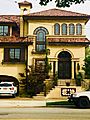
A house in Mill Basin
.jpg)
