
Bergen Beach, Brooklyn facts for kids
Quick facts for kids
Bergen Beach
|
|
|---|---|
|
Neighborhood of Brooklyn
|
|

Carousel of the former Bergen Beach Amusement Park in 1905
|
|
| Etymology: Hans Hansen Bergen, an early settler | |
| Country | |
| State | |
| City | |
| Borough | Brooklyn |
| Community District | Brooklyn 18 |
| Population
(2010)
|
|
| • Total | 45,231 |
| Neighborhood tabulation area; includes Mill Basin, Bergen Beach, Marine Park, and Flatlands | |
| Ethnicity | |
| • White | 73.8% |
| • Black | 10.9 |
| • Hispanic | 7.9 |
| • Asian | 5.6 |
| • Other | 1.8 |
| ZIP Code |
11234
|
| Area codes | 718, 347, 929, and 917 |
Bergen Beach is a neighborhood in Brooklyn, New York City. It's a mostly residential area located on a peninsula next to Jamaica Bay. This means it's almost surrounded by water.
The neighborhood is bordered by Mill Basin and Flatlands. It also sits near Paerdegat Basin and Canarsie. A part of Bergen Beach is called Georgetown. Most people living here are white, and the area feels like a quiet suburb.
Bergen Beach was once an island. The Canarsie Indians, who lived there long ago, called it Winnipague. Later, it was named Bergen Island after an early settler, Hans Hansen Bergen. From 1896 to 1919, a fun amusement park operated here. By 1918, the island was connected to Brooklyn by adding landfill. However, many years passed before homes were built. In the 1960s, a large housing plan called "Georgetowne" was suggested but never built. Because of this, much of Bergen Beach wasn't fully developed until the 1990s.
Bergen Beach is part of Brooklyn Community Board 18. Its main ZIP Code is 11234. The New York City Police Department's 63rd Precinct patrols the area.
Contents
Geography of Bergen Beach
Bergen Beach was originally an island in Jamaica Bay. It was known as "Bergen Island." Most of the island was made of flat, sea-level meadows. But about 60 acres were uplands, which are higher, hilly areas.
These meadows had many shell mounds. These mounds were made from shells of sea creatures like snails and clams. People caught these in Jamaica Bay. In the late 1890s, a wall called a bulkhead was built along the shore. This wall later connected to the higher parts of nearby Mill Basin. This created a long bank that was used to build the Belt Parkway.
Bergen Island was connected to the mainland by 1918. This happened when the marshland was filled in. More fill was added in the 1980s. This added land was not very stable. Because of this, some parts of Bergen Beach have been sinking. Many homes were built with extra steps. This way, if the ground in front of the house sank, more steps could be added. The sinking land can cause ponding and flooding in the streets, even after a little rain.
Today, Bergen Beach is next to Canarsie and Paerdegat Basin. It borders Flatlands to the west. Mill Basin is to the southwest, and Jamaica Bay is to the southeast. The area is mostly for homes, with one- or two-family houses. There are also small shopping areas and places for fun along the water. A part of Bergen Basin is used for light industrial businesses.
History of Bergen Beach
_(cropped).jpg)
Early Days and Settlements
The land around Jamaica Bay, including what is now Bergen Beach, was first home to the Canarsie Indians. They called Bergen Island "Winnipague" or "Winnippague." They also called it "Wimbaco," which means "fine water place." The Native Americans likely used Bergen Island to make wampum, which are beads made from shells. They might have chosen this spot because it was easy to defend. They could see anyone coming from the higher parts of the island.
For many years, the shell mounds left from making wampum were used to build roads and as fertilizer. Even in the mid-1900s, you could still see signs of Native American life. These included stone markings, shell beds, and broken arrow tips. The island may also have had fields where the Indians grew crops.
In 1624, the Dutch Republic started a colony called New Netherland. In 1636, Dutch settlers bought a large area around Jamaica Bay. They founded a town called Achtervelt, which is now Flatlands. The Dutch also set up a trading post on Bergen Island. They renamed it "Mentelaer's Island." In 1646, John Underhill owned the island, but he soon sold it.
In 1664, New Netherland became British New York. Achtervelt was renamed Flatlands. Bergen Island became part of the Town of Flatlands. A settler named Elbert Elbertse bought Bergen Island in 1665. By the 1670s, he leased Bergen Island and two nearby islands. When he passed away in 1686, he left 60 acres of the island to his son.
The island was still known as "Winnipague" through the 1700s. By the early 1800s, it was named after Hans Hansen Bergen. He was an early settler from Norway or the Netherlands. He lived in the Bergen House, which was built before 1800.
By the 1850s, Cornelius Bergen owned a farm on the island. However, Bergen Island stayed mostly undeveloped until the late 1800s. An 1870 map showed that John C. Bergen owned most of the island. It only had two buildings and a dirt road.
Bergen Beach Amusement Park

In the late 1880s, a theater manager named Percy G. Williams and chewing gum maker Thomas Adams bought 300 acres of marshland on Bergen Island. They sold the island to a real estate company in 1892. This company quickly planned streets between Avenues T and Z.
Williams and Adams had planned to build homes. But instead, they decided to create a resort like Coney Island. The resort opened in 1893. It had a dance hall, food stands, rides, and a pier. A streetcar line connected the resort to the rest of the city. The area became known as "Bergen Beach."
In August 1896, a newspaper described Bergen Beach as a "brightly decorated resort." It had a boardwalk with performers, shops, and games. There was a "Casino" for dining and shows, and the Trocadero Theatre. The park also had bathing areas and a beer garden.
In 1902, the Brooklyn Rapid Transit Company wanted to buy the resort but couldn't agree on a price. The trolley service to Bergen Beach had problems, but it later improved. In 1903, a popular musical show played at the casino all season. In 1904, a fire caused $25,000 in damage, but the park was saved. The Percy Williams Amusement Park opened the next year. It was one of several amusement areas in New York City.
A roller skating rink opened in 1907. That year, surveyors mapped the area for a project to dredge Jamaica Bay. They noted that Bergen Beach was one of the few settled places along the bay. Ferry services to Canarsie and Rockaway Beach also ran from Bergen Beach. However, these ferry routes were not very profitable.
A bigger fire in 1910 caused $400,000 in damage to the park. By 1912, two more amusement parks and a scenic railroad were built. But Bergen Beach was less popular than Coney Island and Rockaway Beach. This was because those places had better public transportation. Also, pollution from Barren Island, a waste site, made Bergen Beach less appealing. So, the Bergen Beach resort closed by 1919.
Georgetowne Development
A part of the neighborhood called Georgetowne was undeveloped until the 1960s. A plan was made to build 400 two-story homes called Georgetowne Greens. Many of these homes would be on land that had been filled in. Around the same time, Mayor John Lindsay wanted to build a large housing complex called Harbour Village in the same area. This project would use new building methods. The uncertainty about this project stopped construction on Georgetowne Greens.
The city approved Harbour Village in 1971. But they rejected it in 1972 after many local residents protested. By then, interest in Georgetowne Greens had also faded, and the project was stopped. The first houses built for that development are still there. The area was eventually developed as the Georgetown neighborhood. Some parts of Georgetown remained undeveloped even into the 2000s. A shopping center in Georgetown still uses the name "Georgetowne."
Community Life

Bergen Beach is located on the southern coast of Brooklyn. It has a quiet, suburban feel. The closest stores are at the Georgetown Shopping Center and a Key Food in Mill Basin. Bergen Beach also has the Mill Harbor Condominiums. This is one of the few gated communities in New York City. The neighborhood is home to the St. Bernard Clairvaux Church.
Bergen Beach and Georgetown are part of Brooklyn Community Board 18. This board also includes Canarsie, Mill Basin, Marine Park, and part of Flatlands.
Bergen Beach and Georgetown share the ZIP Code 11234. This ZIP Code also covers Mill Basin, Marine Park, and part of Flatlands. In 2010, the total population of Georgetown, Marine Park, Bergen Beach, and Mill Basin was 45,231. This was an increase of about 5% from 2000.
By the late 1900s, most residents in Bergen Beach were white, often Italian-American. In 1990, only a few black residents lived there. By 2000, there were 28 black residents. However, by 2011, the number of black residents in Southeast Brooklyn had grown by 241%. This was the biggest increase in the city. As of 2010, the population of Southeast Brooklyn was 73.8% White, 10.9% African American, 5.6% Asian, and 7.9% Hispanic or Latino.
Recreation and Parks

The New York City Department of Parks and Recreation manages several parks in the Bergen Beach area. Joseph T. McGuire Park is on Bergen Avenue. It has fields for sports like baseball and volleyball. Bergen Beach Playground is in the northwestern part of Bergen Beach. Hickman Playground is named after Vincent Hickman, a local soldier who died in the Korean War.
Since 1971, the Jamaica Bay Riding Academy has offered horseback riding lessons. It has 80 stables and covers 500 acres within the Gateway National Recreation Area. This area borders Bergen Beach to the south.
Education in Bergen Beach
P.S. 312 is a public elementary school located in Bergen Beach. Success Academy Charter Schools also runs an elementary school in the neighborhood.
The Brooklyn Public Library operates the Mill Basin Library. It is located at 2385 Ralph Avenue. The Mill Basin Library first opened in 1940. It has been in its current building since 1975.
Important Streets
Private Cosmo L. Barone Triangle is a small park area. It is named after Pfc. Cosmo Barone, a soldier from Brooklyn who died in the Vietnam War. Veterans Avenue was renamed to honor soldiers from World War II. It used to be called Island Avenue because it led to Bergen Island.
Mill Lane has several small, separate parts south of Avenue N. One part is in the far western section of Bergen Beach. It used to connect to an old Native American trail called Bergen Beach Road. This trail went from Flatlands to Bergen Island.
Ralph Avenue, which forms the western border of Bergen Beach, is named after Ralph Patchen. He was an early landowner in Brooklyn.
Transportation Options
There isn't much public transportation in Bergen Beach. The neighborhood is quite far from the New York City Subway. Because of this, many residents drive their own cars. The only public transportation available are the B3, B41, and BM1 bus routes. These are run by MTA Regional Bus Operations.
The B3 bus route used to go further into Bergen Beach. But in 2010, its route was shortened. The B41 bus route has two branches. One goes to Bergen Beach, and the other goes to the Kings Plaza shopping mall. The B41 bus is a modern version of the old Flatbush Avenue streetcar route, which stopped running in 1951.
Images for kids
-
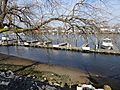
Marina in Bergen Beach

See also
 In Spanish: Bergen Beach (Brooklyn) para niños
