New York Bight facts for kids
The New York-New Jersey Bight is a cool, roughly triangle-shaped curve in the coastline along the Atlantic coast of the United States. It stretches from Cape May in New Jersey all the way to Montauk Point on the eastern tip of Long Island. Because it's touched by the warm Gulf Stream, the weather along this coast is usually mild.
Geography of the Bight
The bight's shape comes from how the coastlines meet. The New Jersey coast runs mostly north-south, while the southern coast of Long Island runs east-west. These two lines form a rough right angle, with the corner pointing towards the mouth of the Hudson River.
The New York Bight Apex is a special part of this area. It includes the Hudson River and Raritan River estuaries (where rivers meet the sea). This apex area reaches about 6–7 kilometers (around 4 miles) out from the coast. It also includes Raritan Bay and the Lower New York Bay.
Weather and Storms
The unique shape of the New York-New Jersey Bight is very important for meteorologists (weather scientists). They study how tropical storms move along the eastern coast of North America. Because of its geography, the New York Metropolitan Area is at high risk for ocean-water surges caused by storms.
Here's why: If a hurricane is off the coast of New Jersey, its strong easterly winds can push a huge amount of water. This water would rush west, along the southern coast of Long Island, and directly into Lower New York Bay. The sharp bend of the New Jersey coast would trap the water, causing widespread flooding. This would especially affect New York City, including the southern parts of Staten Island and Manhattan.
We've seen this happen before. In 1893, a hurricane caused storm surges as high as 9 meters (30 feet)! More recently, Hurricane Sandy in 2012 also caused major flooding in the area.
Underwater World and Geology
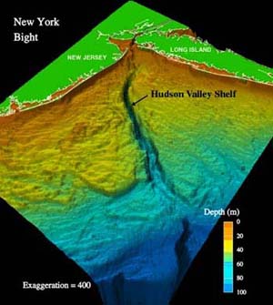
The bottom of the New York Bight is mostly made up of the continental shelf. This is a shallow, underwater extension of the continent. A cool feature here is the Hudson Canyon. This is an ancient, undersea canyon that was carved out by the Hudson River during the ice ages, when sea levels were much lower.
The bight also has important shipping channels. These are like underwater highways that ships use to get to and from New York Harbor.
Wind Power Projects
The Bureau of Ocean Energy Management (BOEM) is a government agency that decides where offshore wind farms can be built. They sell leases to companies that want to put up wind turbines in the ocean. The waters in New Jersey and New York have been leased for developing offshore wind farms. These farms will use the wind to create clean electricity!
In March 2021, the government even considered making the New York Bight a top priority for new offshore wind projects. This shows how important this area is for future energy.
 | DeHart Hubbard |
 | Wilma Rudolph |
 | Jesse Owens |
 | Jackie Joyner-Kersee |
 | Major Taylor |


