
Flushing River facts for kids
Quick facts for kids Flushing River |
|
|---|---|

Seen from Northern Boulevard, looking north
|
|


|
|
| Other name(s) | Flushing Creek |
| Country | United States |
| State | New York |
| City | New York City |
| County/Borough | Queens |
| Physical characteristics | |
| Main source | Jamaica Yard 40°43′06″N 73°49′52″W / 40.718333°N 73.831111°W |
| River mouth | Flushing Bay 40°45′54″N 73°50′36″W / 40.765115°N 73.843364°W |
| Length | 2 miles (3.2 km) |
| Basin features | |
| Tributaries |
|
| Waterbodies | Meadow Lake, Willow Lake |
| Bridges | 7 |
The Flushing River, also known as Flushing Creek, is a waterway in New York City. It flows north through the borough of Queens. Most of the river is inside Flushing Meadows–Corona Park. It eventually flows into Flushing Bay and then the East River.
This river runs through a valley that might have been a much larger riverbed long ago. This was before the last Ice Age. The river helps divide Queens into its western and eastern parts. In the past, the Flushing Creek had three smaller streams, called tributaries, flowing into it: Mill Creek, Kissena Creek, and Horse Brook.
In the 1700s and 1800s, the river separated the towns of Flushing (on its east side) and Newtown (on its west side). Many bridges were built over the river during these centuries. Before the 1939 New York World's Fair, the southern part of the river was made wider. This created Meadow and Willow Lakes. A section of the river was even buried before the 1964 New York World's Fair. Cleanup efforts began in the 1970s because of pollution. However, some parts of the river still need to be cleaned up.
Today, the river is about 4 miles (6.4 km) long. It starts near the Jamaica Yard in Kew Gardens Hills. The river flows through Willow and Meadow Lakes. Then, it goes underground north of the Long Island Expressway. The Flushing River flows for about 2,000 feet (610 m) underground. It then comes back to the surface at the Tidal Gate Bridge. This bridge is at the north end of Flushing Meadows–Corona Park. The rest of the river separates industrial areas of Willets Point and Flushing. Finally, it empties into Flushing Bay.
Contents
The River's Journey
The Flushing Creek used to start in the area now called Kew Gardens Hills. The street Vleigh Place (an old Dutch word for Valley) shows where the river's first waters once flowed. The original source of the river is now under the Kew Gardens Interchange. Today, the river's starting point is near Jamaica Yard, where water flows out of a pipe.
Lakes and Underground Sections
The water from the river's source flows north into Willow Lake and then Meadow Lake. These are two man-made freshwater lakes. They are about 40 and 100 acres (16 and 40 ha) in size. These lakes make up the southern half of Flushing Meadows–Corona Park. Before these lakes were built, the creek wound through tidal marshes in the park. Its mouth was at Flushing Bay, a 6,200-acre (2,500 ha) water body connected to the East River. The two lakes are connected by a small channel under Jewel Avenue.
After Meadow Lake, the Flushing River flows north through a channel. It then goes underground for about 2,500 feet (760 m). This part is under the ramps between the Van Wyck Expressway and Long Island Expressway. The river then feeds into the Pool of Industry and Fountain of the Planets. These were built for the 1964 New York World's Fair. The river runs for about 2,000 feet (610 m) under these fountains.
Where Fresh and Saltwater Meet
After the fountains, the Flushing River flows through the Tide Gate Bridge. Here, the fresh water from the river mixes with the saltwater from Flushing Bay. The channel gets wider as it flows between Willets Point to the west and Flushing to the east. Finally, it empties into Flushing Bay. The northernmost part of the creek mostly has bulkheads (walls) along its banks. The eastern bank has industrial buildings, and the western bank has marshes. The total distance from Meadow Lake to the river's mouth is about 7,000 feet (2,100 m).
The River's Surroundings
The area around the Flushing River, called its watershed, is mostly residential. This means many homes are there. There are also large parks and open spaces. Near the river's mouth, there are industrial areas. Even though much of the Flushing River now follows an artificial path, it can still overflow into nearby areas. This happens especially during heavy rain. Meadow Lake also overflows when it rains. It collects dirty water from some surrounding neighborhoods. This dirty water has caused a lot of pollution in Flushing Bay.
Smaller Streams: The Tributaries
The Flushing River has smaller streams that flow into it. These are called tributaries.
Kissena Creek
Kissena Creek, also known as Ireland Mill Creek, flows into the Flushing River from the east. It starts in what is now Pomonok/Kew Gardens Hills. Most of this creek is now buried underground. It flows through Kissena Park, Kissena Corridor Park, and Queens Botanical Garden. It empties into a special facility called the Flushing Bay Combined Sewer Outfall (CSO) Retention Facility. This facility is on the east bank of the Flushing River. It can hold a lot of water (up to 43.4 million US gallons (164,000,000 L)) from overflows during storms. This water is then pumped to a treatment plant to be cleaned.
Mill Creek
Mill Creek is another tributary that flows into the Flushing River from the east. It joins the river just east of Flushing Bay. Mill Creek used to have two branches. The southern branch is now filled in. It started at Town Pond, which was filled in 1843. The northern branch still exists in a smaller form. It starts near the George U. Harvey Playground in Whitestone. It flows south through areas like College Point Fields and Flushing Airport. The two branches used to meet at Linden Place and 28th Avenue. Now, the northern branch starts in wetlands around Flushing Airport. It flows through the old airport site. Underground pipes and man-made ditches carry the creek from the airport to the Flushing River.
Horse Brook
Horse Brook flows into the Flushing River from the west. It starts in Elmhurst. This creek used to run close to where the Long Island Expressway is now. Horse Brook was gradually covered over during the 1900s. It is now completely underground. However, you can still see its path. It runs under large areas like Queens Center Mall, Rego Center, Newtown High School's athletic field, and LeFrak City.
Crossing the River: Bridges
Many bridges cross the Flushing River, connecting different parts of Queens.
Southern Crossings
The Jewel Avenue crossing is the southernmost bridge over the Flushing River. It was built before the 1939 World's Fair. It was rebuilt and made larger in 1961 to also go over the Van Wyck Expressway.
The Long Island Expressway crosses the river further north. This bridge is near where Horse Brook used to meet Flushing Creek. A crossing called Strong's Causeway was here as early as the 1800s. It was a narrow bridge for most of the 1800s. In 1896, the causeway collapsed. A new bridge opened later that year. This crossing was replaced in 1937 by a bridge for Horace Harding Boulevard. It was then rebuilt into the Long Island Expressway in the late 1950s.

Tide Gate Bridge
Meadow and Willow Lakes are separated from Flushing Bay by a special gate or dam. It's called the "Porpoise Bridge" or "Tide Gate Bridge". This bridge is just south of the Long Island Rail Road's Port Washington Branch trestle. It's at the north end of the Flushing Meadows Golf Center. This dam only lets water flow north towards Flushing Bay. It stops water from flowing south. The dam also works as a bridge for people and cars. It is 37 feet (11 m) wide and 370 feet (110 m) long.
The LIRR trestle is right next to the Tide Gate Bridge. It has a small opening for water to pass through. It was built in the late 1930s and early 1940s.
Roosevelt Avenue Bridge
A bit further north, the Roosevelt Avenue bridge is a double-deck bridge finished in 1927. It was originally a drawbridge, meaning it could open to let boats pass. It was the world's largest fixed-trunnion bascule bridge when it was built. However, it no longer opens. This bridge carries Roosevelt Avenue and the New York City Subway's IRT Flushing Line (7 <7> trains). The subway line was extended to Flushing–Main Street in 1928. This bridge was built thinking the Flushing River might become a busy waterway. But after the 1939 World's Fair, the creek was dammed to the south. This meant the Roosevelt Avenue bridge no longer needed to open.
Northern Boulevard Bridge
The Northern Boulevard crossing is also called the "Flushing Bridge". It is north of the Roosevelt Avenue bridge. Several bridges have been built at this spot. The first one was built around 1800–1801. This makes it the oldest crossing of the Flushing River. Five more drawbridges were built here over time. The current bridge was built in 1980.
Whitestone Expressway Bridge
The northernmost bridge over the Flushing River is for the Whitestone Expressway. A drawbridge opened here in 1939. In 1957, New York state approved a large project to widen the Whitestone Parkway. This included building a new Flushing River bridge. The new bridge opened in 1963. The current fixed bridge was built in 2008.
River Life: Ecology
The Flushing River has different types of environments, from saltwater to freshwater.
Saltwater Section: Near the Bay
_32.jpg)
Long ago, Flushing Meadows was a tidal marsh. This meant the Flushing Creek received water from the tides of Flushing Bay. The northernmost part of the river, near where it meets the bay, is still a saltwater wetland. This area has wild grasses like phragmites and cordgrass. However, human activity has raised the land here. This makes it harder for wetland plants to grow.
On the west bank of the river, north of the LIRR tracks, you can find plants like common reed, field horsetail, chicory, common plantain, and native marsh elder and cordgrass. Many birds, including waterfowl and wading egrets, are seen in the northern part of the river.
Freshwater Section: The Lakes
Willow and Meadow Lakes were built as freshwater lakes. They have a dam to stop the tides from affecting them. However, Flushing Meadows–Corona Park still experiences flooding. The lakes also have a lot of nutrients, like phosphorus, from the old marshland. This leads to too much algae growth, which can cause fish to die in the lakes. The dam stops the regular tidal action that would help clean the lakes. Also, the lakes get pollution and runoff from nearby highways through pipes.
Some fish that live in the ocean can swim into Meadow and Willow Lakes. Fish found in Meadow Lake include American eel, largemouth bass, northern snakehead (which is an invasive species), and white mullet. Willow Lake is named for the many willow trees in the area. Phragmites are also common, but attempts to kill them with pesticides have sometimes harmed fish. Many berry-producing trees and bushes near Willow Lake attract migratory birds. The variety of living things (biodiversity) in these lakes is lower than in other similar water bodies.
Fun on the River: Recreation
Most recreational activities on the Flushing River happen in its southern part. The northern part is mostly industrial, and the middle part is not easy to travel by boat.
Meadow Lake Activities
The land around Meadow Lake has open grass areas, picnic spots, and fields for baseball and cricket. These are all part of Flushing Meadows–Corona Park. Meadow Lake has a boathouse. This is one of two buildings left from the 1939 World's Fair. You can rent boats like rowboats and paddleboats here. Meadow Lake is also where Row New York teams practice rowing.
Meadow Lake hosts the yearly Hong Kong Dragon Boat Festival in New York. Teams from New York practice here in the summer. The American Small Craft Association also has many small sailboats here. They use them for teaching, racing, and fun. Bicycle paths go around Meadow Lake and connect to the Brooklyn–Queens Greenway.
For the 1939 fair, Meadow Lake was briefly called "Fountain Lake" and "Liberty Lake". During the fairs, the north and east shores of the lake were used for amusement. For the 1964 fair, large parking lots were added. These lots were removed after the fair and turned back into parkland.
Willow Lake Preserve
The Willow Lake area of the park is a nature reserve called the Willow Lake Preserve. This area used to have sports fields and trails. But in 1976, it was fenced off and became a preserve. The Willow Lake Trail, a nature path around the lake, was reopened in 2013. It is part of the Willow Lake Preserve.
The River's Past: History
The Flushing River area has a long and interesting history.
How the River Valley Formed
During at least three glacial periods, including the Wisconsin glaciation about 20,000 years ago, huge ice sheets moved south across North America. They carved out valleys, hills, and piles of rock called moraines. Bays and estuaries formed along the north shore of Long Island. The meadows around the Flushing River were created just north of the terminal moraine that crosses Long Island. This moraine was made of sand, gravel, clay, and boulders. It created a drainage divide, meaning rivers north of it, like the future Flushing River, flowed into the north shore. The Flushing Meadows area became a glacial lake, and then a salt marsh after the ice melted. Before the ice ages, the Flushing River valley was used by the Hudson River to flow south into the Atlantic Ocean. Throughout the 1800s, wetlands continued to be along the Flushing River. Waterfowl, fiddler crabs, and fish lived here.
Early Settlers
The area was first settled by Algonquian Native Americans of Long Island. These were the Canarsee and Rockaway Lenape groups. They lived in the coastal wetlands across Queens and Brooklyn.
The town of Flushing was settled in 1645 by the Dutch West India Company. Both the town and the creek were named after the port of Vlissingen in the Netherlands. The first European settler near Flushing Creek was Robert Coe. He was an Englishman who built a house near Horse Brook on the creek's western bank.
1800s and Early 1900s
_(14582985327).jpg)
The first permanent bridge over the Flushing Creek was the Northern Boulevard bridge. It was built in 1801 and rebuilt six times until 1980. Before the bridge, a ferry carried people across the creek.
In the 1850s, the New York and Flushing Railroad built a train line across the river. It led to a train station in Flushing. Other railroad lines were built nearby in the 1870s. All these lines were later bought by the Long Island Rail Road. Most were eventually closed, except for the main line, which became the LIRR's Port Washington Branch.
In the early 1900s, the northern part of the Flushing River was home to a rowing club called the Wahnetah Boat Club. Its clubhouse was near the Northern Boulevard bridge. The club was founded in 1900.
Changes in the 20th Century
Around 1907, a builder named Michael Degnon bought large areas of marshland near Flushing Creek. This land was considered almost worthless at the time. Degnon wanted to create a large industrial port around Flushing Bay. By 1911, he had a plan to widen the Flushing River and build docks for ships. The plan also included many factories. In 1913, money was set aside to make the channel deeper. The next year, plans were made for a 5.4-mile (8.7 km) canal to connect Flushing River and Newtown Creek.
To create the port, Degnon started filling the wetlands with household coal refuse ashes and street sweepings. The northern end of the site was filled by dredging. The filling was finished in 1916. However, the plan to build a port stopped in 1917 because of World War I. Dumping of ash into the meadows continued. This pollution was even mentioned in the famous book The Great Gatsby.

In 1930, New York City parks commissioner Robert Moses planned many parks and highways. This included a Flushing River Park. Five years later, Flushing Meadows was chosen for the 1939 World's Fair. Work on the fair site began the next year. The project mainly involved leveling the ash mounds. The leftover material was used to fill other areas of the meadow. Two parts of the river were dug out to create Meadow and Willow Lake. Much of the rest of the Flushing River was put into underground culverts (pipes). The Tidal Gate Bridge was built at the park's northern end. This was to stop tides from flooding the lakes. The lakes would also hold extra storm runoff. By then, Horse Brook was already covered, and Kissena Creek was being covered. The Flushing River became smaller and only navigable north of Roosevelt Avenue.
For the 1964 New York World's Fair, the middle section of the creek was filled in for parkland. Flowing out of Meadow Lake, the creek became a canal under the Van Wyck Expressway. It then narrowed into pipes going into the Fountain of the Planets. From there, the pipes took the water toward the tidal bridge, where it became a creek again.
Images for kids
-
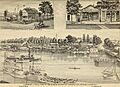
Busy Flushing Harbor in 1882. Bridge on the right carries Broadway, later called Northern Boulevard
-
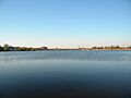
Meadow Lake, created in the 1930s by expanding Flushing River
