
Brooklyn–Queens Greenway facts for kids
The Brooklyn–Queens Greenway is a special path for bikes and walkers. It connects many parks and roads in Brooklyn and Queens, two parts of New York City. It stretches from Coney Island in the south all the way to Fort Totten in the north, near Long Island Sound.
Along the way, you can visit cool places like the New York Aquarium, Brooklyn Museum, Brooklyn Botanic Garden, New York Hall of Science, and even Citi Field where the Mets play! The New York City Department of Transportation and the New York City Department of Parks and Recreation are working together to build and improve this path. Most of the Greenway is separate from car traffic, making it safer for everyone. Some parts are marked bike lanes or signed routes on streets.
This amazing path is about 40 miles (64 km) long. It includes parts of bike routes in Prospect Park, and along Eastern Parkway and Ocean Parkway in Brooklyn. In Queens, it goes through Alley Pond Park, Cunningham Park, Forest Park, Kissena Park, and the Ridgewood Reservoir.
Contents
Exploring the Queens Greenway
The northern end of the Brooklyn–Queens Greenway is in Little Bay Park. This is near the Throgs Neck Bridge.
Start Your Adventure in Queens
From Little Bay Park, the Greenway goes south. It passes the entrance to Fort Totten Park. This part of the path is known as "Joe Michaels Mile." After crossing busy Northern Boulevard, the route becomes a well-marked bike path. It follows quiet streets and climbs up to the old Long Island Motor Parkway.
The Long Island Motor Parkway Section
The section of the Greenway on the Long Island Motor Parkway is raised above the ground. Most of it is closed to cars, making it safe for bikes and walkers. From here, one part of the Greenway goes east into Alley Pond Park. Here you can find picnic tables, tennis courts, and locker rooms. This eastern path continues to the Alley Pond Adventure Course. It also connects to the Winchester Boulevard bike lane.
Journey Through Queens Parks
The main path of the Greenway goes west. It winds through Cunningham Park and Kissena Park. Then it goes around the south side of the Queens Botanical Garden on streets. It crosses the Whitestone Expressway on its own high bridge. This leads you into Flushing Meadows–Corona Park.
Discovering Flushing Meadows
Once inside Flushing Meadows, the Greenway runs along the eastern edges of Meadow and Willow Lakes. It then leaves the park onto Jewel Avenue. The route continues on quiet streets like Hoover and Coolidge Avenues. It also uses busier streets like Main Street and crosses Queens Boulevard. The Greenway enters Forest Park at the Overlook. It continues down Forest Park Drive. Along this path, you'll pass the Urban Park Ranger station near Woodhaven Boulevard. You'll also see the George Seuffert, Sr. Bandshell and the Forest Park Golf Course. After leaving the park, the Greenway continues along parts of Cooper Avenue and other local streets. It finally reaches Highland Park and the Ridgewood Reservoir.
Riding Through the Brooklyn Greenway
After leaving Highland Park, the Brooklyn part of the Greenway uses local streets in East New York. These streets connect to Eastern Parkway.
Smooth Rides in Brooklyn
From Eastern Parkway to the end, there is very little mixing with car traffic. The Eastern Parkway bike route is about 3 miles (5 km) long. Then, you'll ride for 2 miles (3 km) through Prospect Park. Finally, the 5-mile (8 km) Ocean Parkway leads you to the southern end. This is at the Riegelmann Boardwalk in Coney Island.
Hills and Flat Paths
The Brooklyn part of the Greenway is generally flatter than the Queens part. However, in Prospect Park, you will cross over a small hill. This hill is part of a natural ridge that divides Long Island.
Images for kids
-
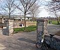
North end
-
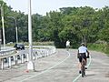
Joe Michael's Mile
-
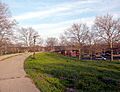
Crossing Long Island Expressway to Cunningham Park


