Long Island Motor Parkway facts for kids
Quick facts for kids |
|
|
Long Island Motor Parkway
|
|
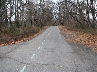
A piece of the Long Island Motor Parkway in Queens, looking east (around 2008)
|
|
| Location | Roughly Alley Pond and Cunningham Parks, between Winchester Blvd. and Clearview Expressway, between 73rd Ave. and Peck Ave., Queens, New York City (historic district only) |
|---|---|
| Area | 10 acres (4.0 ha) (historic district only) |
| Built | October 10, 1908 |
| Architect | E.G. Williams; E.H. Brown |
| NRHP reference No. | 02000301 |
| Added to NRHP | April 1, 2002 |
The Long Island Motor Parkway was a special road on Long Island, New York. It was also known as the Vanderbilt Parkway. This road was the very first one built just for cars!
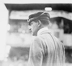
A rich man named William Kissam Vanderbilt II paid for it to be built. He made sure it had bridges and overpasses. This meant cars didn't have to stop at intersections. The parkway opened on October 10, 1908. It closed in 1938 because the state took it over for unpaid taxes. Today, parts of the old parkway are still used. Some sections are now regular roads, and others are fun bike trails.
Contents
Building the First Car-Only Road
William Kissam Vanderbilt II loved car racing. He was the great-grandson of a famous businessman, Cornelius Vanderbilt. In 1904, William started the Vanderbilt Cup. This was the first big car race on public roads.
But racing on regular streets was dangerous. Two people died, and many were hurt during races. So, Vanderbilt decided to build a safer road. He wanted a special highway just for cars. It would have smooth turns and guard rails. It would also be made of concrete. This new road would be the first of its kind in the world. It was designed so cars could drive fast without stopping.
The original plan was for the road to be 70 miles long. It would go from New York City all the way to Riverhead. But only 45 miles were built. This section went from Queens to Lake Ronkonkoma. It cost about $6 million to build.
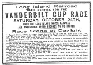
Construction started in June 1908. On October 10, 1908, a 10-mile part of the road opened. It was used for races in 1908, 1909, and 1910. But another accident in 1910 killed two people. After that, New York State banned racing on public roads. This ended the parkway's use as a race track.
By 1911, the road reached Lake Ronkonkoma. It was also extended in the west to Fresh Meadows. The Long Island Motor Parkway was truly special. It was the first road just for cars. It was also the first concrete highway in the United States. And it was the first to use bridges to avoid intersections.
Parkway Races and Winners
The Long Island Motor Parkway hosted four major car races. These were part of the American Automobile Association's Champ Car series.
The first race was on October 30, 1909. Harry Grant won that race. On October 1, 1910, three races were held. About 300,000 people came to watch! Harry Grant won the main race again. Frank Gelnaw won a shorter race. And Bill Endicott won another race that day.
| Date | Winner | Laps |
|---|---|---|
| October 30, 1909 | Harry Grant | 22 |
| October 1, 1910 | Harry Grant | 22 |
| October 1, 1910 | Frank Gelnaw | 15 |
| October 1, 1910 | Bill Endicott | 10 |
How to Get On and Off the Parkway
The Long Island Motor Parkway was a toll road. This means you had to pay money to use it. There were only a few places to get on and off. These were called toll booths. Short roads connected the parkway to local streets.
When the parkway first opened, the toll was $2. That was a lot of money back then! It was lowered to $1.50 in 1912. By 1917, it was $1. And in 1938, it was only 40 cents.
Famous architect John Russell Pope designed the first six toll houses. He also designed the Jefferson Memorial. These toll houses were built so the toll collectors could live there. This way, they could collect tolls all the time. The most famous toll house still stands in Garden City. It was moved in 1989. Now it's the office for the Garden City Chamber of Commerce.
Why the Parkway Closed
By the 1920s, new ways of building roads came along. This made the Long Island Motor Parkway seem old-fashioned. It was less than 20 years old, but it was already becoming obsolete. Around this time, Robert Moses was planning a new road called the Northern State Parkway.
In 1929, some people wanted New York State to buy the Motor Parkway. They thought it could become part of the state's new road system. But the parkway was narrow. It was only 16 to 22 feet wide. Its bridges were also steep. These things didn't meet the new road standards. Robert Moses didn't like the idea. He said the parkway had been a "white elephant" for a long time. He meant it was expensive and not very useful. He also said it would need a lot of work to be updated.
When the Northern State Parkway was finished, it was the end for the Motor Parkway. In 1937, the part of the parkway in Suffolk County was given to the county. In July 1938, the rest of the land was given to Nassau County and the Long Island State Parks Commission. This is when the parkway officially closed.
What's Left of the Parkway Today
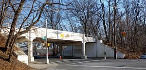
Most of the old road in Queens is now a bicycle trail. It runs through Cunningham Park and Alley Pond Park. This trail is part of the Brooklyn–Queens Greenway. You can find it starting at Francis Lewis Boulevard in Cunningham Park. The path goes south, next to 199th Street. It crosses a bridge over 73rd Avenue. Then it turns east and crosses Francis Lewis Boulevard on another bridge.
The path continues through the park. It goes under the Clearview Expressway through a tunnel. Then it crosses Hollis Hills Terrace on a third bridge. After leaving the park, you can get to 209th and 210th Streets in Hollis Hills. The path goes through a wooded area. It crosses over Bell Boulevard on a bridge. You can also get to 220th Street from there. After crossing Springfield Boulevard on another bridge, the main bike path goes north. The old road continues as a smaller path. It enters Alley Pond Park. It goes under the Grand Central Parkway. Finally, it ends at Union Turnpike and Winchester Boulevard.
In Nassau County, much of the old road has been changed. Some parts are now regular roads. Other parts are used for power lines. A small piece of the road is still in Lake Success. It's not marked and not open to the public. Most of this part is on the property of Great Neck South High School. The old Great Neck toll house is now part of a private home.
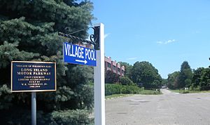
You can see another section of the old road near Willis Avenue. This is between Albertson and Wiliston Park. On the east side of Willis Avenue, a few hundred yards of the road are still there. They lead to the Williston Park pool.
|
|
|
|---|---|
| Location: | Melville–Ronkonkoma |
| Length: | 14.51 mi (23.35 km) |
The road still exists as a continuous county road in Suffolk County. It's called Vanderbilt Motor Parkway (CR 67). It goes from Half Hollow Road in Dix Hills to its original end in Ronkonkoma. Signs along the way call it Vanderbilt Parkway or Motor Parkway.
From Half Hollow Road, it goes northeast to NY 231. It runs next to the Northern State Parkway. It crosses the Sagtikos State Parkway. Then it heads south to I-495, the Long Island Expressway. The parkway then goes east, next to the expressway. It crosses the expressway and continues southeast to NY 111. It heads north, crossing the expressway again. Then it curves east and crosses NY 454. It continues east across Old Nichols and Terry roads. Finally, it turns northeast and ends at Rosevale Avenue in Ronkonkoma, near the lake.
<mapframe latitude="40.775342" longitude="-73.251343" zoom="10" width="263" height="245" align="right"> { "type": "FeatureCollection", "features": [ { "type": "Feature", "properties": { "stroke": "#cc0000", "title": "Suffolk County Route 67 (Vanderbilt Parkway)", "stroke-width": 3 }, "geometry": { "type": "LineString", "coordinates": [ [ -73.3651085640304, 40.796091990188266 ], [ -73.36454364471138, 40.79876918535168 ], [ -73.36425019428134, 40.799361441522336 ], [ -73.36179278790951, 40.80172286293832 ], [ -73.35874747484924, 40.80472316886573 ], [ -73.3580380305648, 40.80513233135812 ], [ -73.35031284950675, 40.80786513458271 ], [ -73.34952327422799, 40.808354469205895 ], [ -73.3486886881292, 40.809737281556245 ], [ -73.34812190383673, 40.81077234974873 ], [ -73.34773482754827, 40.81106845666102 ], [ -73.34730785340072, 40.81125601678858 ], [ -73.34684047847988, 40.81135288934091 ], [ -73.34613522514702, 40.81135767904105 ], [ -73.3419364783913, 40.81120018971318 ], [ -73.33779954817147, 40.81115137270366 ], [ -73.33711830899121, 40.81124621533385 ], [ -73.33641020581128, 40.8115294418999 ], [ -73.33569602575153, 40.81191293299407 ], [ -73.33536045625806, 40.81225150715996 ], [ -73.33487755386159, 40.81256863736268 ], [ -73.33445257041605, 40.81280453329073 ], [ -73.33392953965813, 40.81294254328007 ], [ -73.3321641641669, 40.813267457183535 ], [ -73.32502858713269, 40.8144649796343 ], [ -73.3230081293732, 40.81471247770533 ], [ -73.31837352365255, 40.814534823474126 ], [ -73.31727582961322, 40.814697792147754 ], [ -73.31674567423762, 40.81492939855417 ], [ -73.31579223275186, 40.81579758234071 ], [ -73.31207267940046, 40.81925073019252 ], [ -73.3113436214626, 40.81988270206315 ], [ -73.31013268791139, 40.820491071584506 ], [ -73.30927354283632, 40.82079680830512 ], [ -73.30811901949346, 40.820940351843625 ], [ -73.30672846175732, 40.82087971218962 ], [ -73.30426208674909, 40.82012279016978 ], [ -73.29857194796205, 40.81819876245845 ], [ -73.29566812142731, 40.817286586869145 ], [ -73.2871050015092, 40.81550178199492 ], [ -73.28570974990727, 40.81471390502718 ], [ -73.2846754230559, 40.8137680596904 ], [ -73.28244022093715, 40.80942067707419 ], [ -73.28171242028476, 40.80856706503757 ], [ -73.28054398298265, 40.80789983793496 ], [ -73.27679090201856, 40.80594386017009 ], [ -73.27553001232447, 40.80551827034584 ], [ -73.27412981539966, 40.8053156891383 ], [ -73.2662690151483, 40.80587096192789 ], [ -73.25481757521631, 40.806711983256115 ], [ -73.24673440307379, 40.80737338549651 ], [ -73.23804010637106, 40.80795991846712 ], [ -73.23607832193376, 40.80790269287171 ], [ -73.2342215627432, 40.806717883564225 ], [ -73.2310552150011, 40.80399784934452 ], [ -73.22766574099661, 40.80246806662175 ], [ -73.22611852549016, 40.802060473919575 ], [ -73.22443258948626, 40.80177146481289 ], [ -73.2225592341274, 40.8016547187357 ], [ -73.22114319540562, 40.801729525077285 ], [ -73.2146742520854, 40.8024888459149 ], [ -73.21307804435493, 40.80278768632738 ], [ -73.21111252997072, 40.80341182065805 ], [ -73.2100490340963, 40.80370910246214 ], [ -73.20718933828176, 40.80406592769475 ], [ -73.20604587905109, 40.80434141271956 ], [ -73.2035386003554, 40.805077768045464 ], [ -73.2016138220206, 40.80555379971407 ], [ -73.20047912187874, 40.80573493575095 ], [ -73.1997933983803, 40.80568570232715 ], [ -73.19936872925611, 40.80560883847458 ], [ -73.19904925301672, 40.80549447834756 ], [ -73.1981910718605, 40.805099276147324 ], [ -73.19731474388392, 40.80472129720642 ], [ -73.19677021354437, 40.8046704451544 ], [ -73.1962686404586, 40.80472875212032 ], [ -73.19554750341922, 40.804966420681 ], [ -73.19493943825366, 40.80544556197232 ], [ -73.1940333126113, 40.806505599030174 ], [ -73.19372372701764, 40.80750782222972 ], [ -73.19362699985506, 40.810190726582746 ], [ -73.1934690847993, 40.81127809384636 ], [ -73.19316100794823, 40.811848002937396 ], [ -73.19253379013391, 40.81233131322289 ], [ -73.19184140302242, 40.812591951035515 ], [ -73.19103619549425, 40.81269519720246 ], [ -73.18524543195963, 40.81264971181417 ], [ -73.18341708742084, 40.81263727786715 ], [ -73.18102485034615, 40.81283926577886 ], [ -73.17751740105452, 40.813059745286466 ], [ -73.17603677976878, 40.8128262926416 ], [ -73.17333340644838, 40.813038588674374 ], [ -73.16453048028053, 40.81392896853609 ], [ -73.16338484175503, 40.81413732794191 ], [ -73.16268231254072, 40.814506752729905 ], [ -73.16219758708031, 40.81496673081762 ], [ -73.16188104450703, 40.81547539270848 ], [ -73.16168444696814, 40.81598979159467 ], [ -73.1615302618593, 40.81670527454658 ], [ -73.16095153335483, 40.817203551625546 ], [ -73.16039505880327, 40.81734310659737 ], [ -73.15965552348645, 40.81740064122074 ], [ -73.15425380598755, 40.817354461284424 ], [ -73.15123933833094, 40.817436227660714 ], [ -73.14923421945423, 40.81759918920703 ], [ -73.13980566803366, 40.81841843124266 ], [ -73.13803570345044, 40.81864834369151 ], [ -73.13667875714602, 40.81904362377795 ], [ -73.13565101008864, 40.81947927596931 ], [ -73.13400551676752, 40.820366175825775 ], [ -73.12980790156873, 40.823432872744704 ] ] } } ] } </mapframe> Even though it's not a private road anymore, much of it was still easy to recognize in the 1970s. New roads were built through it over time. In the middle of the road, around Islandia, new buildings and businesses have made the road wider. It now looks like a regular highway.
In 2008, the Long Island Motor Parkway turned 100 years old! On October 30, 2011, a special event celebrated 100 years since the Lake Ronkonkoma section was finished. Cars made before 1948 had a parade. They drove from Dix Hills to Lake Ronkonkoma. The parade was led by the winner of the 1909 and 1910 Vanderbilt Cup races.
 | DeHart Hubbard |
 | Wilma Rudolph |
 | Jesse Owens |
 | Jackie Joyner-Kersee |
 | Major Taylor |


