Ocean Parkway (Brooklyn) facts for kids
Quick facts for kids Ocean Parkway |
|
|---|---|
|
Ocean Parkway (Brooklyn) highlighted in red
|
|
| Route information | |
| Maintained by NYSDOT and NYCDOT | |
| Length | 4.86 mi (7.82 km) |
| Restrictions | No commercial vehicles (except on service road) |
| Major junctions | |
| South end | Sea Breeze Avenue / Surf Avenue in Brighton Beach |
| North end | |
| Highway system | |
| Numbered highways in New York Interstate • U.S. • N.Y. (former) • Reference • County |
|
|
Ocean Parkway
|
|
 |
|
| Built | 1874–76 |
| Architect | Frederick Law Olmsted; Calvert Vaux |
| NRHP reference No. | 83001697 |
| Significant dates | |
| Added to NRHP | September 8, 1983 |
Ocean Parkway is a long, tree-lined road in Brooklyn, New York City. It stretches for almost 5 miles (8 kilometers). This special road is known as a boulevard.
The New York State Department of Transportation (NYSDOT) calls it New York State Route 908H. This is a special number used for official records, but you won't see signs for it.
Contents
What is Ocean Parkway?
Ocean Parkway is about five miles long. It runs from Prospect Park in the north all the way to the Atlantic Ocean at Brighton Beach in the south.
The parkway starts at Machate Circle, near Prospect Park. It then heads south, joining the Prospect Expressway for a short part. After the expressway ends, Ocean Parkway continues through neighborhoods like Windsor Terrace and Kensington.
It also passes through Midwood, Homecrest, and Sheepshead Bay. The parkway finally ends at Surf Avenue in Brighton Beach. This is very close to the Riegelmann Boardwalk and the ocean.
How the Parkway is Designed
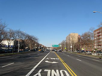
Ocean Parkway has a unique design, much like another famous Brooklyn road, Eastern Parkway. It's very wide, about 210 feet (64 meters) in total.
In the middle, there's a main road with seven lanes for cars. On each side of this main road, there are wide grassy areas called medians. These medians are about 20 feet (6 meters) wide. They have paths for walking and biking.
Outside the medians, there are two smaller roads called service roads. These are about 25 feet (7.6 meters) wide. They help people get to the buildings along the parkway. On the very outside, there are sidewalks for pedestrians.
Many trees, benches, and even playing tables are found along the pedestrian paths. There's a special bike lane on the western median. The parkway runs between two subway lines, the Culver and Brighton lines.
History of Ocean Parkway
Ocean Parkway was designed by famous landscape architects Frederick Law Olmsted and Calvert Vaux. They also designed Central Park and Prospect Park.
In 1866, they suggested building Ocean Parkway and Eastern Parkway. Their idea was to connect Prospect Park to Coney Island (with Ocean Parkway) and to East New York (with Eastern Parkway). They were inspired by grand boulevards in cities like Berlin and Paris.
However, Olmsted and Vaux made their parkways even better. They added service roads and tree-lined medians. This separated local traffic from faster-moving vehicles. Since the road to Coney Island would reach the ocean, it was named "Ocean Parkway."
Building the Parkway
New York State approved the plan to build Ocean Parkway in 1869. Construction began in 1874. By 1875, the first part of the parkway was open, reaching Kings Highway. The rest of the road to Coney Island was finished in 1876.
Landowners near the parkway helped pay for its construction. The total cost was about $1 million at the time.
In 1894, a special change was made: the pedestrian path was split to create the first dedicated bike path in the United States! Cyclists had a speed limit of 10 miles per hour (16 km/h) on the parkway and 12 miles per hour (19 km/h) on the bike path.
Modern Changes
In the 1950s, the Prospect Expressway was built. It replaced the northernmost part of Ocean Parkway.
By the 1970s, people wanted to protect Ocean Parkway. In 1975, it was named a landmark by New York City. This helped make sure it would be taken care of. The parkway was then restored and repaved. In 1978, a special zoning district was created for Ocean Parkway. This meant new buildings had to follow certain rules, like having landscaped front yards. The restoration work was finished in 1980.
More recently, in 2016 and 2017, traffic rules were updated at major intersections. This included adding traffic lights for the service roads. As part of the Vision Zero program, which aims to reduce traffic accidents, speed limits were lowered to 25 miles per hour (40 km/h).
Horseback Riding on the Parkway
In the past, Ocean Parkway also had special paths for horseback riding, called bridle paths. These were on the eastern side of the parkway. People could rent horses near Prospect Park and ride all the way to Coney Island.
In the early years, horse and sleigh races even took place on these paths. There were also race tracks near Ocean Parkway, like the Gravesend Race Track. However, horse racing stopped at these places around 1908 or 1910.
As cars became more popular in the mid-1900s, fewer people rode horses. The bridle paths were removed in 1978. Today, you can still rent horses at Kensington Stables nearby, but the old bridle paths on Ocean Parkway are now paved over and no longer used for riding.
Neighborhood Around Ocean Parkway
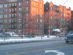
Many buildings along Ocean Parkway are mid-to-high rise apartment buildings. Around 1900, many homes were built here. After World War I, some large mansions were constructed. People moved to Ocean Parkway from other parts of Brooklyn.
In the 1920s, more apartment buildings and family homes were built. The northern part of the parkway became known for its fancy apartment buildings with elevators. After World War II, apartments started to replace older homes.
Because of the "Special Ocean Parkway District" rules from 1978, new buildings must have a 30-foot (9-meter) deep "landscaped front yard." This means they need green spaces in front, not just pavement.
There are also several schools along the parkway. These include Abraham Lincoln High School and Mir Yeshiva.
By the 1970s, the areas around Ocean Parkway became home to many Syrian Jewish families. In 1980, it was estimated that 60 to 70 percent of the people living there were Syrian Jewish. Because of this, you can find many synagogues, yeshivas (Jewish schools), and other Jewish institutions in the area.
Transportation
The New York City Subway's BMT Brighton Line (which carries the Q train train) has a station called Ocean Parkway station in Brighton Beach.
Two bus lines also use parts of the parkway. The B1 bus travels on the parkway in Sheepshead Bay. The B9 bus uses the parkway for one block in Midwood.
Major intersections
| County | Location | Mile | Roads intersected | Notes |
|---|---|---|---|---|
| Brighton Beach | 0.00 | 0.00 | Sea Breeze Avenue / Surf Avenue | At-grade intersection |
| 0.56 | 0.90 | Exit 7 on Belt Parkway | ||
| Gravesend | 2.13 | 3.43 | Kings Highway | |
| Kensington | 4.86 | 7.82 | Church Avenue | Access via service roads only |
| 4.86 | 7.82 | Continuation beyond Church Avenue; exit 6 on NY 27 | ||
| 1.000 mi = 1.609 km; 1.000 km = 0.621 mi | ||||
See also
 In Spanish: Ocean Parkway (Brooklyn) para niños
 | Toni Morrison |
 | Barack Obama |
 | Martin Luther King Jr. |
 | Ralph Bunche |


