
Newtown Creek facts for kids
Quick facts for kids Newtown Creek |
|
|---|---|

The Creek in Long Island City
|
|

Newtown Creek and its tributaries
|
|
| Country | United States |
| State | New York |
| Municipality | New York City |
| Physical characteristics | |
| Main source | Confluence of East Branch and English Kills 40°43′06″N 73°55′27″W / 40.718412°N 73.924127°W |
| River mouth | East River 2nd Street and 54th Avenue in Long Island City 0 ft (0 m) 40°44′14″N 73°57′40″W / 40.73734°N 73.96112°W |
| Length | 3.5 mi (5.6 km) |
| Basin features | |
| Tributaries |
|
Newtown Creek is a 3.5-mile (6-kilometer) long waterway in New York City. It acts as a natural border between the boroughs of Brooklyn and Queens. This creek is an estuary, which means it's a partly enclosed coastal body of water where fresh water from rivers mixes with salt water from the ocean.
Over time, Newtown Creek became a very busy industrial area. Sadly, this also made it one of the most polluted places in the United States. It contains many years of discarded chemicals, huge amounts of spilled oil (like the Greenpoint oil spill), and raw sewage from New York City's sewer system.
Because of this pollution, Newtown Creek was named a "Superfund site" in 2010. This means the United States government will help clean up the area.
Contents
Exploring Newtown Creek's Path
_aerial_02_(9454373737).jpg)
Newtown Creek starts where two smaller streams, the East Branch and English Kills, meet near the border of Brooklyn and Queens. From there, it flows into the East River in Long Island City, Queens. This area is very industrial, with many factories and warehouses along the water.
The creek and its smaller branches, like Dutch Kills, Whale Creek, Maspeth Creek, and English Kills, have many pipes that drain into them. When it rains heavily, these pipes can release untreated sewage directly into the water.
Because the surrounding neighborhoods are fully connected to sewer systems, the creek doesn't get much fresh water naturally. It mostly stays still, except for the ocean tides. A thick layer of polluted mud, sometimes as deep as 25 feet (7.6 m), covers the bottom of the creek.
Smaller Streams that Join the Creek
Several smaller waterways, called tributaries, flow into Newtown Creek.
Dutch Kills: A Warehouse Waterway
Dutch Kills begins in Long Island City and flows into Newtown Creek. Its banks are mostly lined with warehouses. In the past, it was a longer stream that helped merchants move goods.
Whale Creek: Home to a Treatment Plant
Whale Creek starts near the Newtown Creek Wastewater Treatment Plant in Greenpoint, Brooklyn. It used to be longer but was made straighter and partly filled in to build the treatment plant. Today, you can walk along a nature path next to the remaining part of Whale Creek.
Maspeth Creek: From Plateau to Industrial Area
Maspeth Creek flows from Maspeth, Queens, into Newtown Creek. Long ago, it started on a higher area called the Ridgewood Plateau. This plateau separated the water systems of Newtown Creek and the Flushing River.
English Kills: A Major Sewage Drain
English Kills starts from a large pipe that releases sewage in East Williamsburg. It drains a huge amount of sewage every year. Its path was straightened in the late 1800s. Bridges, like the Metropolitan Avenue Bridge, cross over it.
East Branch: Another Sewage Source
The East Branch also starts from a pipe that releases sewage. It is only crossed by the Grand Street Bridge.
Newtown Creek's Past
Early Days: A Natural Waterway
Newtown Creek gets its name from "New Town" (Nieuwe Stad), an old Dutch and British settlement in what is now Elmhurst, Queens. Before cities grew and industries developed in the 1800s, Newtown Creek was wider and shallower. It even had islands, like Mussel Island. It collected water from many areas that are now neighborhoods in Brooklyn and Queens.
During the American Revolutionary War, British General Warren had his base along the creek. Later, a famous type of apple, the Newtown Pippin, grew on an estate here. These apples became very popular, even praised by important figures like Benjamin Franklin and Queen Victoria.

The Rise of Industry and Pollution
In the early 1800s, farmers used the creek to transport their goods. But traffic grew a lot when oil from Pennsylvania started coming up the creek. More oil refineries were built, including one by Robert Chesebrough who made Vaseline.
By the 1880s, John D. Rockefeller's company, Standard Oil, was processing millions of gallons of crude oil each week. The land around the creek became a huge area of docks, oil stills, tanks, and pipelines. Other industries, like paint makers and chemical companies, also set up factories there.
These industries produced a lot of waste, which was often burned or dumped into the air or the creek. It's thought that these factories created hundreds of thousands of gallons of waste material every week. This waste included a tar-like substance called sludge acid.
By the mid-1800s, Newtown Creek was a major industrial waterway. The city even started dumping raw sewage into it in 1866. People protested the pollution, and newspapers wrote about it often. However, little changed because the industries brought a lot of money to the area.
Even when The New York Times reported in 1885 that Standard Oil was dumping sludge acid into the creek, covering the banks at low tide, it didn't make much difference. By the end of the 1800s, the Times reported that no living things could survive in the creek.
Chemical plants and copper factories also polluted the creek. One of the largest was the Laurel Hill Chemical Works, which operated for over 100 years. When the company sold the land, it was found to have dangerous levels of heavy metals. The company was then ordered to clean it up.
There were plans to build a canal connecting Newtown Creek with the Flushing River. This canal would have helped clean out the stagnant water. However, the canal was never built. Later, a dredging project in the 1930s removed Mussel Island.
Efforts to Clean Up the Creek
The first steps to clean up Newtown Creek began in 1924, when the government passed a law about oil pollution.
In 1967, New York City built the Newtown Creek Wastewater Treatment Plant. This is now the largest sewage treatment facility in the city. It handles a lot of the sewage from Manhattan. During normal times, it processes millions of gallons of sewage daily. However, during heavy rain, the system can get overwhelmed.
When the plant's capacity is exceeded, untreated sewage and street runoff can flow directly into Newtown Creek. This is called a "combined sewer overflow" (CSO). These overflows can happen even with a small amount of rain. They dump trash, chemicals, oil, and harmful germs into the creek.
In 1998, the city started a project to expand the treatment plant. This work was finished in 2014. The plant is known for its unique "digester eggs," which are tall, metallic structures lit up at night with blue lights. To make up for the plant's expansion, the city built a nature walk along the creek in 2009. A local boat club also built a boatyard to allow people to access the creek.
Even with the expanded plant, the city still faces challenges in meeting clean water rules. Overflows from the plant still happen about once a week.
In 2007, lawsuits were filed about the Greenpoint oil spill. Then, in 2010, the United States Environmental Protection Agency officially named Newtown Creek a Superfund site. This decision paved the way for a major cleanup of the waterway.
Water Quality Challenges
Even with the expanded wastewater treatment plant, small amounts of rain can still cause raw sewage and street runoff to flow into the creek. This ongoing pollution is a big problem for the creek's water quality. As the city continues to grow, the risk of these sewage overflows increases.
In 2013, it was reported that cleanup crews expected to find dangerous substances like arsenic, cesium-137, and polychlorinated biphenyls (PCBs) in addition to oil and human waste.
Bridges Over Newtown Creek
Several bridges cross Newtown Creek, connecting Brooklyn and Queens.
The Pulaski Bridge is the westernmost crossing. It was built in 1954. Upstream from there is the Greenpoint Avenue Bridge, which was built in 1987. The last bridge upstream is the Kosciuszko Bridge, which carries the Brooklyn Queens Expressway. The original Kosciuszko Bridge was built in 1939 and was replaced with new bridges between 2017 and 2019.
Some bridges that once crossed Newtown Creek have been taken down. These include the Vernon Avenue Bridge and the Penny Bridge. The Maspeth Plank Road bridge was also removed because it blocked boats.
Images for kids
-
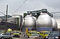
Three "digester eggs" at Newtown Creek Wastewater Treatment Plant
-
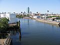
Newtown Creek from the Greenpoint Avenue Bridge


