
Maspeth, Queens facts for kids
Quick facts for kids
Maspeth
|
|
|---|---|
|
Neighborhood of Queens
|
|

Maspeth Federal Savings Bank
|
|
| Country | |
| State | |
| City | |
| County/Borough | |
| Community District | Queens 5 |
| Settlement | 1642 |
| Founded by | Dutch settlers |
| Named for | Maspat Indians |
| Population | |
| • Total | 30,516 |
| Ethnicity | |
| • White | 79.2% |
| • Hispanic | 7.6% |
| • Asian | 12.0% |
| • Black | 0.8% |
| • Other/Multiracial | 1.4% |
| Economics | |
| • Median income | $92,075 |
| Time zone | UTC−5 (EST) |
| • Summer (DST) | UTC−4 (EDT) |
| ZIP Code |
11378
|
| Area codes | 718, 347, 929, and 917 |
Maspeth is a neighborhood in the borough of Queens in New York City. Dutch and English settlers started it in the early 1600s. Maspeth shares borders with Woodside to the north, Sunnyside to the northwest, and Greenpoint, Brooklyn to the west. It also borders East Williamsburg, Brooklyn to the southwest, Fresh Pond and Ridgewood to the south, and Middle Village and Elmhurst to the east.
Maspeth is part of Queens Community District 5. Its ZIP Code is 11378. The New York City Police Department's 104th Precinct patrols the area. Local government representatives for Maspeth are from the New York City Council's 29th and 30th Districts.
Contents
History of Maspeth

Early Settlement and Conflicts
The name "Maspeth" comes from the Mespeatches Indians. They were one of the 13 main Native American tribes on Long Island. The name means "at the bad waterplace." This is because there were many swamps in the area.
Dutch and English settlers first explored the Maspeth area in the early 1600s. The Dutch bought land in what is now Queens in 1635. They began creating towns a few years later. In 1642, they settled Maspat. This made Maspeth the first English settlement in Queens. The agreement signed between the Native Americans and the settlers was the first on Long Island. This agreement, called the "Newtown Patent," gave 13,000 acres (5,300 ha) to the settlers.
However, conflicts with the Maspat tribe forced many settlers to move to Elmhurst in 1643. Native Americans attacked the settlement the next year, destroying it. The settlers who survived went back to Manhattan.
Returning Settlers and Growth
In 1652, settlers came back to the area. They settled a bit further inland from the first Maspat location. This new area was called Middleburg. It later grew into the town of Elmhurst, which borders Maspeth.
About 28 English Quakers founded the village of Maspeth. It had important water and milling (grinding) businesses along Newtown Creek and Maspeth Creek. By the late 1700s, two storekeepers sold food and clothes at the Maspeth Town Docks. After the American Revolutionary War, villagers improved roads with crushed oyster shells or wooden planks.
Columbusville was an older name for a part of Maspeth. It was a housing development built in 1854–55. This area later became part of Maspeth. The name was no longer used by the 1890s.
Between 1925 and 1939, Maspeth was home to a shanty town for Boyash (Ludar) Gypsies. This area was later cleared.
Maspeth's Layout and Features


Industrial and Residential Areas
Maspeth has different types of areas. The part from 43rd Street to 58th Street, including an area called Furman Island, is mainly industrial. From 60th Street to 74th Street, it is mostly residential homes.
A company called Phelps Dodge Corporation was in Maspeth from 1920 to 1983. Waste from their site polluted Newtown Creek. This creek separates parts of Brooklyn and Queens and is used by barges. In the 2000s, local leaders started working to clean up Newtown and Maspeth Creeks.
Freight trains use the Long Island Rail Road's Montauk Branch and the Bushwick Branch. These lines are used by the LIRR and other railway companies. The LIRR Bay Ridge Branch, which is only for freight, separates Maspeth from Elmhurst and Middle Village. There's a plan for a new rail freight station in West Maspeth. This would help reduce truck traffic in New York City. However, some residents are against it because they don't want more trucks in their neighborhood.
Large gas tanks, known as the Elmhurst gas tanks and Maspeth gas tanks, used to be in the area. They were taken down in 2001.
Housing and Commerce
Most of Maspeth has single and multi-family houses. There are not many apartment buildings, except for the Ridgewood Gardens co-ops. Houses in Maspeth generally cost between $400,000 and $600,000. A special group of houses built in 1930 can be found near Grand Avenue, 79th Street, and Calamus Avenue.
Most of the shopping and businesses in Maspeth are located along Grand Avenue.
Cemeteries and Community Feel
Cemeteries take up a large part of Maspeth. They are mostly separate from the homes. The Mount Olivet Cemetery is the biggest cemetery in the neighborhood. It is on a high hill and used to be a vacation spot. It was planned in 1850. Famous people buried there include cosmetics expert Helena Rubinstein and sixteen victims of the 1911 Triangle Shirtwaist Factory fire.
Many residents say Maspeth feels like a small town. This is because industrial areas and cemeteries surround it. I-495, the Long Island Expressway, cuts through the neighborhood. But several crossings connect the two parts of Maspeth. There are many community groups that work to keep the neighborhood's small-town feel. For example, they stopped a Home Depot from being built where Elmhurst Park is now.
Community Places
Maspeth Town Hall
The Maspeth Town Hall community center is on 72nd Street. It was a one-room schoolhouse from 1897 to 1932. Later, a girls' club and the Works Progress Administration used it. It was a New York City Police Department police station until 1971. The building was fixed up and became a community center in 1972.

Other important places in the neighborhood include the local Chamber of Commerce, the Lions Club, and the Maspeth Federal Savings Bank.
Parks and Memorials
September 11 Memorial
A September 11 memorial is at 69th Street and Grand Avenue. It honors the local FDNY Squad 288 and HAZMAT 1 firehouse members who died in the September 11 attacks on the World Trade Center. This firehouse lost the most members of any FDNY unit. The monument is next to I-495 and faces the World Trade Center site. You can see the One World Trade Center from there. An annual ceremony is held at the monument on September 11. The Walk of Honor, started in 2006, is also in the square. It honors local activists and leaders.
Local Parks
The New York City Department of Parks and Recreation operates public parks in Maspeth. These include Frontera Park at 69th Street and I-495, and Principe Park at Maurice and 54th Avenues.
Maspeth is also home to the Metropolitan Oval. This is a playing field for soccer players. It offers a view of the Manhattan skyline.
At Grand Avenue and I-495, there is a plaque for a "Horse Cars Rest Stop." There used to be a horse cart barn nearby. It is now Peter Charles Park, a small pocket park. When I-495 was built in the 1950s, it also destroyed many streets. The construction left small triangular plazas, like at 57th Road and 73rd Place. This is where the "Quick Brown Fox Park," another pocket park, is located. The park is named after a story about a quick brown fox.
Interesting Places in Maspeth

A sign at the crossing of Flushing, Grand, and Maspeth Avenues shows where streetcar lines used to split. These lines are now served by the B57, Q58, Q59 bus routes.
On the front yard of the Church of the Transfiguration on Perry Avenue, there has been a copy of a Lithuanian roadside shrine since 1981.
St. Saviour’s Church, built in 1847, was located on land once owned by lawyer James Maurice. After a fire in 1970, it was cleaned. But by 2005, developers bought the church to tear it down. The New York City Landmarks Preservation Commission had refused to make the church a landmark. Many people were against this. However, its front was taken apart and stored at All Faiths Cemetery by 2008. Despite community efforts to make a park on the site, the church's old location became warehouses by 2011. Plans for a new church site in All Faiths Cemetery were approved.
The Ridgewood Gardens apartment/co-op complex is on a hill called the Ridgewood Plateau. It was built on 72 acres (29 ha) of woods. These woods were owned by James Maurice and given to the Episcopal Church in 1850. The apartment complex was built later. It is known for a step street that goes down the hill. It also has a very old, graffiti-covered lamppost on that street.
James Maurice used to live at a home at 1 Hill Street. It was sold in 1909.
The building where Anton Fausner’s wheelwright and wagonmaker’s shop was located is on Grand Avenue. Later, an auto shop was in that building. In 2006, that house was torn down and replaced by a bank. Farmers from Long Island used to visit the wheelwright. They would stay at the Queens County Hotel, built in 1851 along Grand Avenue, on their way to markets.

The Maspeth Theater was the neighborhood's largest theater in the 1920s. It was built in 1924 with 1,161 seats. It closed in 1965. Famous performers like Judy Garland appeared there. Maspeth had many other theaters in the 1920s.
A former Maspeth supermarket, Wielback's Grocery, later became Griff's Hardware. In 2000, the building became Griff's Laundry, a laundromat that closed less than ten years later. The building was known for a neon sign on its front.
Clinton Hall, built in the 1920s, had balconies and a large chandelier. It is now a laboratory and industrial offices. It is named after a mansion built by Judge Joseph Sackett. New York Governor DeWitt Clinton planned the Erie Canal from this mansion. The land around the Sackett-Clinton House became a park by 1910. The mansion burned down in 1933.
The Clinton Diner, at Maspeth and Maurice Avenues, was built in 1935. It is a truck stop that appeared in the movie Goodfellas. The Queens Head Tavern, nearby, was a American Revolutionary War-era tavern. It was used as a stagecoach stop later.
Notable Streets in Maspeth
- Flushing Avenue crosses another Maspeth road called Fresh Pond Road. This road goes south to Myrtle Avenue and was named after a former pond called "Fresh Pond."
- Grand Avenue used to be a winding road before it was straightened.
- Maspeth Avenue is broken up in the area because of the Newtown Creek and where the old Maspeth gas tanks were.
- Maspeth Plank Road was a road made of wooden planks. It went from Williamsburg to Newtown. It crossed the English Kills. This road no longer exists.
- Melvina Place, off Maspeth Avenue, is named after a small part of Maspeth.
- North Hempstead Plank Road, now called 57th Avenue, split off from Grand Avenue. It went to Corona. The road was named after North Hempstead, New York, which is now in Nassau County. 57th Avenue has many old houses from the 1850s. It also has some old barns that are now used as garages.
Maspeth Population and People
Population Data
Based on the 2010 United States Census, Maspeth had 30,516 people. This was an increase of 1,600 people (5.5%) from the 28,916 counted in 2000. The neighborhood covers 818.44 acres (331.21 ha). This means there were about 37.3 people per acre (92.1/ha).
The racial makeup of Maspeth was:
- 79.2% White (18,080 people)
- 0.8% African American (253 people)
- 0.1% Native American (31 people)
- 12.0% Asian (3,676 people)
- 0.0% Pacific Islander (1 person)
- 0.4% from other races (115 people)
- 0.8% from two or more races (245 people)
Hispanic or Latino people made up 27% (8,115 people) of the population.
Community Board 5, which includes Maspeth, Ridgewood, Middle Village, and Glendale, had 166,924 residents in 2018. The average life expectancy there was 81.4 years. This is similar to the average for all New York City neighborhoods. Most residents are young and middle-aged adults. About 22% are 0–17 years old, 31% are 25–44, and 26% are 45–64.
Income and Diversity
As of 2017, the average household income in Community Board 5 was $71,234. In 2018, about 19% of Maspeth and Ridgewood residents lived in poverty. This is similar to the average for Queens and New York City. About 6% of residents were unemployed. This is lower than the average for Queens (8%) and New York City (9%). About 46% of residents have trouble paying their rent. This is lower than the city averages. Maspeth, Ridgewood, Middle Village, and Glendale are considered high-income areas compared to the rest of the city.
Many people in Maspeth are of Polish, Italian, or Irish descent. You can see this in the many Irish pubs and Italian and Polish stores. People from Eastern European countries, Germany, China, or Hispanic backgrounds (mostly Puerto Ricans from nearby Ridgewood) have also moved to the area. Maspeth has a large Polish population. The New York area has the second largest community of Polish Americans after Chicago.
Transportation in Maspeth
Maspeth does not have direct subway or express bus connections to Manhattan. Local buses connect residents to the subway. However, bus service during off-peak hours can sometimes be unreliable. Local bus routes include:
- B57 bus along Flushing Avenue
- Q18 bus along 65th Place and 69th Street
- Q39 bus along 58th Street, Grand Avenue, and Fresh Pond Road
- Q47 bus along Calamus Avenue and 69th Street
- Q58 bus along Grand Avenue and Fresh Pond Road
- Q59 bus along Grand Avenue
- Q67 bus along Metropolitan Avenue, 69th Street, and the Long Island Expressway
The narrow Grand Street Bridge carries Grand Street from Williamsburg across the English Kills and Newtown Creek. It then becomes Grand Avenue, which is Maspeth's main street for dining and businesses. Grand Avenue continues east to end at Queens Boulevard in Elmhurst. Maspeth also has access to I-278, the Brooklyn-Queens Expressway and I-495, the Long Island Expressway. The Brooklyn-Queens Expressway crosses the Newtown Creek on the Kosciuszko Bridge.
Economy
Hagstrom Map, a popular brand of road maps in the New York metropolitan area for many years, was based in Maspeth.
Education in Maspeth
School Performance
Maspeth and Ridgewood generally have fewer college-educated residents than the rest of New York City. As of 2018, 33% of residents aged 25 and older have a college degree or higher. In contrast, 16% have less than a high school education, and 50% are high school graduates or have some college education. For comparison, 39% of Queens residents and 43% of city residents have a college education or higher.
The percentage of Maspeth and Ridgewood students doing well in math increased from 36% in 2000 to 67% in 2011. Reading achievement also rose from 42% to 49% during the same time.
Maspeth and Ridgewood have a lower rate of elementary school students missing many school days. In these areas, 14% of elementary school students missed twenty or more days per school year. This is lower than the citywide average of 20%. Also, 82% of high school students in Maspeth and Ridgewood graduate on time. This is more than the citywide average of 75%.
Schools in Maspeth


The New York City Department of Education runs the public schools.
- IS 73, The Frank Sansivieri Intermediate School, is a middle school for students in its zone.
- PS 58, The School of Heroes, was named in 2002 to honor the victims of the September 11 attacks. It is known as one of the best schools in Maspeth for its many extra activities and programs.
- PS 153, Maspeth Elementary School
- Maspeth High School is the first public high school in Maspeth. It opened on September 6, 2012. It was first located in Middle Village.
Private schools in the area include:
- Holy Cross R.C. Church—Maspeth: Offers Polish School and CCD classes on weekends.
- Saint Stanislaus Kostka School: A Catholic school for Nursery through 8th grade.
- Martin Luther High School: A private high school for grades 9–12.
Library
The Queens Public Library's Maspeth branch is located at 69-70 Grand Avenue.
Notable People from Maspeth
- June Blum (1929–2017), an artist.
- John J. Pesch (1921–2010), who was the national director of the Air National Guard from 1974 to 1977.
- Vincent Piazza (born 1976), an actor known for his roles in Boardwalk Empire and Jersey Boys.
- Jimmy Ring (1895–1965), a Major League Baseball player.
- Richard Vetere (born 1952), a writer whose play The Third Miracle is set in Maspeth.
Images for kids
-
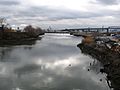
Maspeth Creek, looking west toward Newtown Creek
-
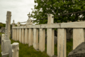
Triangle Shirtwaist Factory Memorial, Mount Zion Cemetery
-
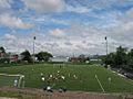
The Metropolitan Oval


