
East River facts for kids

The East River is a special waterway in New York City. It's not really a river, but a tidal strait. This means it's a narrow channel of water that connects two larger bodies of water, and its flow is affected by the ocean's tides. The East River links Upper New York Bay in the south to Long Island Sound in the north.
This important strait separates Long Island (where the boroughs of Queens and Brooklyn are) from the island of Manhattan and the Bronx. Many famous bridges and tunnels cross the East River, helping people travel easily across the city. The Brooklyn Bridge is one of the oldest and most well-known.
Contents
What is the East River?
The East River is a busy waterway that plays a big role in New York City. It's about 16 miles (26 kilometers) long. Because it's a tidal strait, the water flows in different directions depending on the tide. This makes it unique compared to a typical river that flows only one way.
The river's strong currents have shaped the land around it over many years. It has also been very important for trade and transportation throughout New York's history. Ships and boats have used it for centuries to move goods and people.
Connecting New York's Boroughs
The East River acts like a natural border between different parts of New York City. On one side, you have Manhattan, the famous island with skyscrapers and busy streets. On the other side, you have Brooklyn and Queens, which are part of Long Island. The river also touches the Bronx at its northern end.
Because the river separates these areas, building bridges and tunnels across it was a huge challenge. These connections were vital for the city to grow and for people to get around easily. They helped New York become the big city it is today.
Famous Bridges of the East River
Many impressive bridges span the East River. These bridges are not just ways to cross the water; they are also famous landmarks.
- Brooklyn Bridge: Opened in 1883, this is one of the oldest suspension bridges in the United States. It connects Manhattan and Brooklyn. It was an amazing engineering feat for its time.
- Manhattan Bridge: Located north of the Brooklyn Bridge, this suspension bridge also connects Manhattan and Brooklyn. It carries cars, trains, and pedestrians.
- Williamsburg Bridge: This bridge connects Manhattan's Lower East Side with Brooklyn's Williamsburg neighborhood. It was once the longest suspension bridge in the world.
- Queensboro Bridge: Also known as the 59th Street Bridge, this cantilever bridge connects Manhattan to Queens. It's famous for its unique design without suspension cables.
- Robert F. Kennedy Bridge (Triborough Bridge): This is a complex of three separate bridges connecting Manhattan, Queens, and the Bronx. It's a major transportation hub.
- Hell Gate Bridge: This railway bridge connects Queens to the Bronx. It's known for its large steel arch and was once the longest arch bridge in the world.
These bridges are not only important for daily travel but also beautiful parts of the New York City skyline.
Tunnels Under the River
Besides bridges, several tunnels run under the East River. These tunnels carry subways, cars, and even trains. They were built to handle the increasing traffic as New York City grew. Building tunnels under a busy tidal strait was a very difficult task for engineers.
Some of the well-known tunnels include:
- The Steinway Tunnel, which carries the 7 train subway line.
- The Queens Midtown Tunnel for cars.
- The Brooklyn-Battery Tunnel (also known as the Hugh L. Carey Tunnel) for cars.
- Several subway tunnels that connect Manhattan to Brooklyn and Queens.
These tunnels are hidden beneath the water but are just as important as the bridges for keeping New York City moving.
Images for kids
-
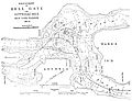
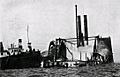
A navigation map for Hell Gate from c. 1885, after many of the obstructions had been removed.
-
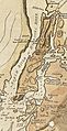
A map from 1781
-
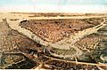
A "bird's-eye" view of New York City from 1859; Wallabout Bay and the East River are in the foreground, the Hudson River and New York Bay in the background
-
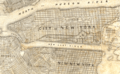
James E. Serrell's plan for an expanded Manhattan and a straightened East River
-
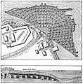
The excavations and tunnels used to undermine Hallert's Point
-
Firefighters working to put out the fire on the listing General Slocum
-
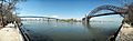
A panorama of the suspension section of the Robert F. Kennedy Bridge (left) and the Hell Gate Bridge (right), as seen from Astoria Park in Queens
-
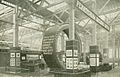
Exposition display showing cross-section of East River railroad tunnel to Pennsylvania Station
-
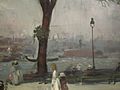
William Glackens's 1902 painting of East River Park, in the Brooklyn Museum
-
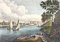
Blackwells Island from Eighty Sixth Street, Currier & Ives (1862); Blackwell's Island is now known as Roosevelt Island
-
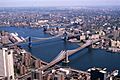
Manhattan Bridge (top) and Brooklyn Bridge (bottom); Manhattan is on the left, Brooklyn on the right (1981)
-
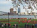
The East River passes children playing football in East River Park (2008)
-
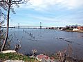
Powell's Cove, in Whitestone, Queens (2009)
-
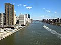
The East River flows past the Upper East Side (2009)
-
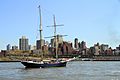
The East River with Brooklyn Heights in the background, Topsail Schooner Clipper City (2013)
-
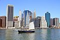
The East River and Lower Manhattan (2013)


See also
 In Spanish: Río Este (Nueva York) para niños
