
Flushing–Main Street station (IRT Flushing Line) facts for kids
Quick facts for kids
Flushing–Main Street
|
|||||||||
|---|---|---|---|---|---|---|---|---|---|

Center track
|
|||||||||
| Station statistics | |||||||||
| Address | Main Street and Roosevelt Avenue Queens, NY 11354 |
||||||||
| Borough | Queens | ||||||||
| Locale | Flushing | ||||||||
| Coordinates | 40°45′34″N 73°49′49″W / 40.75944°N 73.83028°W | ||||||||
| Division | A (IRT) | ||||||||
| Line | IRT Flushing Line | ||||||||
| Services | 7 alltimes (all times) <7>rushpeak (rush hours until 9:30 p.m., peak direction) | ||||||||
| Transit connections | |||||||||
| Structure | Underground | ||||||||
| Platforms | 2 island platforms | ||||||||
| Tracks | 3 | ||||||||
| Other information | |||||||||
| Opened | January 21, 1928 | ||||||||
| Station code | 447 | ||||||||
| Accessible | |||||||||
| Opposite-direction transfer available | N/A | ||||||||
| Station succession | |||||||||
| Next north | (Terminal): 7 alltimes <7>rushpeak | ||||||||
| Next south | Mets–Willets Point: 7 alltimes <7>rushpeak | ||||||||
|
|||||||||
|
|||||||||
|
|||||||||
|
|
|||||||||
|
Main Street Subway Station (Dual System IRT)
|
|||||||||
| MPS | New York City Subway System MPS | ||||||||
| NRHP reference No. | 04001147 | ||||||||
| Added to NRHP | October 14, 2004 | ||||||||


The Flushing–Main Street subway station is the last stop on the IRT Flushing Line of the New York City Subway. You can find it at Main Street and Roosevelt Avenue in Downtown Flushing, Queens.
This station is served by the local 7 train all the time. During busy rush hours, the express <7> train also stops here.
The Flushing–Main Street station first opened on January 21, 1928. It was the final part of the Flushing Line to be built in Queens. Even though there were plans to extend the line further east, this never happened. In 2018, it was the busiest subway station in Queens and the 11th busiest in the entire New York City subway system!
Contents
History of the Flushing–Main Street Station
How the Station Was Planned and Built

Back in 1910, there were big plans to expand New York City's subway lines. Queens, where Flushing is, didn't get as many new lines at first because other areas like Brooklyn and the Bronx needed subways more. The Flushing Line was one of the first new lines planned for Queens. It would connect Flushing and Long Island City to Manhattan.
When the line was being planned, Flushing was a quiet village. The street now known as Roosevelt Avenue was called Amity Street. Local leaders in Flushing really wanted the subway line to be built underground as a tunnel, not as an elevated line (a train on tracks above the street). They worried that an elevated train would make the neighborhood noisy and crowded. It could also lower property values and force the street to be widened too much.
In January 1913, people in Flushing voted to demand an underground station. Building a subway was more expensive, but it would cause fewer problems for the neighborhood. In June 1913, the city decided to extend the line from 103rd Street–Corona Plaza east to Flushing.
Construction of the station began on April 21, 1923. Workers used a method called cut-and-cover. This means they dug a big trench, built the subway structure inside it, and then covered it up. The station officially opened on January 21, 1928.
After the station opened, Downtown Flushing grew into a busy area for shopping and transportation. In 1939, express trains started running to the station. Because so many people used the station, an extra exit was added on the east side after World War II. This new entrance opened on October 28, 1948.
Changes Over the Years
In the mid-1950s, the platforms at Main Street and other Flushing Line stations were made longer. This allowed longer, 11-car trains to use the line. Another entrance was built on the north side of Roosevelt Avenue in the 1960s.
The station needed a big update, and plans for renovation started in the 1970s. In 1981, it was listed as one of the subway system's most run-down stations. Finally, in 1994, money was found for the renovation. Between 1999 and 2000, the station got a major makeover.
One of the most important changes was adding an elevator near the eastern exit at Lippmann Plaza. This made the station accessible for people with disabilities, following the Americans with Disabilities Act of 1990. The project also added new street entrances and a large entrance hall.
The Flushing–Main Street station has been recognized as an important historical place since October 2004. It's listed on the National Register of Historic Places because it's a great example of the architecture from when it was built.
More improvements are planned for the station! As part of a project from 2015 to 2019, New York City set aside money to make subway stations more accessible and less crowded. At Main Street, four new staircases will be added between the platforms and the upper level (mezzanine). More stairs will also be added from the street to the mezzanine. This will help people move around the station more easily.
Plans for Extending the Line

The Flushing–Main Street station was not originally meant to be the very last stop on the line. There were many ideas to extend the subway further east, to places like Whitestone, College Point, and Bayside.
In 1913, people in these areas wanted the subway to reach them. There was even talk of using parts of the LIRR tracks for the subway. However, the LIRR didn't want the subway to compete with its own train service.
Over the years, various plans for extending the Flushing Line were suggested. These included branches to College Point and Bayside. But these plans often faced problems like high costs or conflicts with other train lines. After World War II, new budgets didn't allow for the Flushing extension.
Even in 1956, there were proposals to extend the line east to Bayside and College Point, and even south to John F. Kennedy International Airport. However, all these proposals have not been built, and Flushing–Main Street remains the end of the line.
Station Layout
| G | Street level | Entrances/exits to Main Street | |
| M | Concourse | Fare control, MetroCard machines, station agent | |
| P Platform level |
Track 1 | ← |
Lippmann Plaza, fare control, MetroCard machines, escalator to Roosevelt Avenue |
| Island platform |
|||
| Track M | ← |
||
| Island platform |
|||
| Track 2 | ← |
||

The station has three tracks and two platforms in the middle, called island platforms. These platforms are about 16 feet wide. The entire station is located underground, beneath Roosevelt Avenue.
When express trains are running during busy times, they use the middle track and the southernmost track. Local trains use the northernmost track. The walls of the station have cool mosaic tiles that say "MAIN STREET".
At the west end of the platforms, you'll find offices and a control tower. Train crews report here, and the tower controls the trains on the Flushing Line. West of the station, the subway tracks come out of the tunnel and go onto an elevated bridge over Flushing Creek.
Main Street is one of only seven underground stations on the Flushing Line. It's also the only underground station east of Hunters Point Avenue.
Station Exits
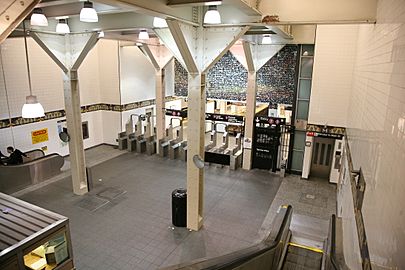
The station has nine entrances at street level, leading to two different areas where you pay your fare. The main entrance is in the middle of the platforms. It has a mezzanine (an upper level) with the fare control area and a ticket booth. Stairs lead up to all four corners of Main Street and Roosevelt Avenue.
There's also a newer fare control area at Lippmann Plaza. This area has a very high ceiling, about 40 feet below the street. It has an elevator that makes the station accessible for everyone. There are also three escalators and a stairway to the street. In 1998, a new art piece called Happy World was added above the turnstiles. Lippmann Plaza is a walking area that leads to a parking lot and several bus stops.
Bus Service
The Flushing–Main Street subway station is a major hub for buses in Queens. It's one of the busiest places where subway and local buses connect. Over 20 bus routes run through or end in this area. You can also connect to the nearby Long Island Rail Road station here.
| Route | Operator | Stop location | North/West Terminal | South/East Terminal | via | notes |
|---|---|---|---|---|---|---|
| MTA-operated bus routes | ||||||
|
Q12
|
NYCT | Roosevelt Avenue (near Lippmann Plaza) | Little Neck | Sanford Avenue, Northern Boulevard | ||
|
Q13
|
39th Avenue (near Lippmann Plaza) | Fort Totten | Northern Boulevard, Bell Boulevard | |||
|
Q15
Q15A |
Roosevelt Avenue (near Lippmann Plaza) | Beechhurst | 41st Avenue, 150th Street | |||
|
Q16
|
39th Avenue (near Lippmann Plaza) | Fort Totten | Bayside Avenue | |||
|
Q17
Q17 LTD |
Main Street | Jamaica–Merrick Boulevard | Kissena Boulevard, Horace Harding Expressway, 188th Street, Hillside Avenue | |||
|
Q19
|
MTA Bus | Roosevelt Avenue (west of Main Street) | Astoria | Northern Boulevard, Astoria Boulevard | ||
|
Q20A
Q20B |
NYCT | Main Street | College Point | Jamaica–Merrick Boulevard | 20th Avenue (Q20A), 14th Avenue (Q20B), Main Street, Archer Avenue | |
|
Q25
Q25 LTD |
MTA Bus | College Point | Jamaica–LIRR Station | 127th Street, Kissena Boulevard, Parsons Boulevard | ||
|
Q26
|
NYCT | Roosevelt Avenue (near Lippmann Plaza) | Auburndale | Parsons Boulevard, 46th Avenue, Hollis Court Boulevard | Rush-hours only | |
|
Q27
Q27 LTD |
Main Street | Queens Village or Cambria Heights | Kissena Boulevard, 46th Avenue, 48th Avenue, Springfield Boulevard | |||
|
Q28
|
39th Avenue (near Lippmann Plaza) | Bay Terrace Shopping Center | Northern Boulevard, Crocheron Avenue, 32nd Avenue, Corporal Kennedy Street | |||
|
Q34
|
MTA Bus | Main Street | Whitestone | Jamaica–LIRR Station | Union Street, Kissena Boulevard, Parsons Boulevard | |
|
Q44 SBS
|
NYCT | Bronx Zoo–West Farms Square | Jamaica–Merrick Boulevard | Cross Bronx Expressway, Parsons Boulevard, Union Street, Main Street, Archer Avenue | Converted into Q44 Select Bus Service on November 29, 2015. | |
|
Q48
|
Roosevelt Avenue (west of Main Street) | LaGuardia Airport | Roosevelt Avenue, 108th Street, Ditmars Boulevard | |||
|
Q50 LTD
|
MTA Bus | Co-op City, Bronx | Whitestone Expressway, Hutchinson River Parkway, Bruckner Boulevard, Co-op City Boulevard | Limited-stop Service | ||
|
Q58
Q58 LTD |
NYCT | 41st Road | Ridgewood Terminal | College Point Boulevard, Corona Avenue, Grand Avenue, Fresh Pond Road | ||
|
Q65
Q65 LTD |
MTA Bus | Main Street | College Point | Jamaica–LIRR Station | College Point Boulevard, 45th Avenue, 164th Street | |
|
Q66
|
Roosevelt Avenue (west of Main Street) | Long Island City–Queens Plaza | Northern Boulevard, 35th Avenue, 21st Street | |||
| Nassau Inter-County Express (NICE)-operated bus routes | ||||||
|
n20G
|
NICE Bus | Roosevelt Avenue (near Lippmann Plaza) | Great Neck LIRR Station | Northern Boulevard | Transfer at Great Neck for n20H to Hicksville | |
Ridership
In 2017, about 18.7 million people used the Flushing–Main Street station. This made it the 10th busiest station in the entire subway system. It was also the busiest station outside of Manhattan and the busiest station served by only one subway line. On an average weekday, about 58,511 passengers used the station.
Attractions and Points of Interest Near the Station

The station is located in Downtown Flushing, which is also known as Flushing Chinatown. This is one of New York City's largest Asian communities.
Many important city and national landmarks are close by. You can find them along the Queens Historical Society's Freedom Mile, which goes around downtown Flushing:
- Flushing Armory, on Northern Boulevard
- Flushing High School on Northern Boulevard
- Flushing Town Hall, at Northern Boulevard and Linden Place
- John Bowne House, at 37th Avenue and Bowne Street
- Kingsland Homestead and the Weeping Beech, at 37th Avenue
- Lewis H. Latimer House, at 137th Street and Leavitt Street
- Old Quaker Meeting House, at Northern Boulevard and Linden Place
- St. George's Church, on Main Street
Other interesting places to visit include:
- Bowne Street Community Church, at Bowne Street and Roosevelt Avenue
- Flushing Main Post Office, on Main Street
- Free Synagogue of Flushing, at Kissena Boulevard and Sanford Avenue
- Lippmann Plaza, a pedestrian area between 39th Avenue and Roosevelt Avenue
- Queens Library, Flushing Branch, at Main Street and Kissena Boulevard
Gallery
-

Eastern entrance, refurbished in 1999
-
Eastern entrance ticket hall
-
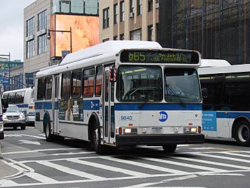
A Q65 bus outside the station, at Main Street and Roosevelt Avenue


- nycsubway.org – IRT Flushing Line: Main Street/Flushing
- nycsubway.org – Happy World Artwork by Ik-Joong Kang (1998)
- Station Reporter – 7 Train
- The Subway Nut – Main Street–Flushing pictures
- MTA's Arts For Transit – Flushing–Main Street (IRT Flushing Line)
See also
 In Spanish: Flushing–Calle Main (línea Flushing) para niños
