
Tibbetts Brook facts for kids

Tibbetts Brook is a stream in New York. It flows from the city of Yonkers in Westchester County into the Bronx in New York City.
This brook used to flow into Spuyten Duyvil Creek. Now, part of it flows underground. It ends above ground at the south end of Van Cortlandt Lake, which is in Van Cortlandt Park. From there, the water goes into city sewers. It then drains into the Harlem River or a water treatment plant.
Tibbetts Brook is very important for both Van Cortlandt Park and Tibbetts Brook Park. There are ideas to bring the southern part of the brook back above ground. This process is called "daylighting."
Contents
Where Does Tibbetts Brook Flow?

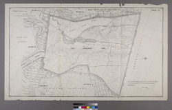

Bottom: Parts of an 1895 map of The Bronx, showing Tibbetts Brook.
Tibbetts Brook starts in H.F. Redmond Junior Memorial Park in Yonkers. It flows south through two man-made lakes in Tibbetts Brook Park. It runs next to the Saw Mill River Parkway and an old railroad path.
After the park, the brook crosses into Van Cortlandt Park in the Bronx. It flows through the Van Cortlandt Golf Course. Then, it empties into Van Cortlandt Lake. This lake was made in 1699 by building a dam on the stream. The brook now ends at the south edge of the lake.
Rainwater from storm drains also flows into the brook in Yonkers.
At the end of the lake, the brook's water goes into an underground brick tunnel. This tunnel joins a larger sewer system under Broadway. This sewer carries rainwater, house water, and other waste. Most of this water goes to the Wards Island Water Pollution Control Plant to be cleaned.
When it rains a lot, the sewer can overflow. Then, some water goes into the north end of the Harlem River. Because of buildings and roads, the brook now flows through many underground tunnels and pipes.
In the past, Tibbetts Brook had two smaller streams that joined together. These streams met at the north end of Tibbetts Brook Park. One stream started in Redmond Park, and the other went as far as Runyon Heights. The Saw Mill River Parkway was built over the western stream in the 1920s.
Until the late 1800s, the brook flowed past the south end of Van Cortlandt Park. It went through the area where Van Cortlandt Stadium is now. It crossed Broadway and continued through the Kingsbridge neighborhood. It followed the path of modern Tibbett Avenue. The brook then flowed into Spuyten Duyvil Creek. This creek used to separate the Bronx from Marble Hill, Manhattan.
Before the 1700s, Tibbetts Brook split into two streams. One stream went into the Spuyten Duyvil Creek. The other went into the Harlem River. These two streams formed a triangle-shaped island called Paparinemo. This island is now part of the Kingsbridge neighborhood.
The brook also had many smaller streams flowing into it. The northern part of the brook in Yonkers and the park has fresh water. South of the park, it used to be a tidal area with salty marshes. These marshes were home to fish and birds. The water from the brook created wet areas around the stream. The original Spuyten Duyvil Creek has since been filled in. Now, the Harlem River Ship Canal is there instead.
What's in a Name?

The local Lenape Native Americans called Tibbetts Brook Mosholu. This word means "smooth stones" or "small stones." The name "Mosholu" was later given to Mosholu Parkway.
European settlers named it "Tibbetts Brook." It was named after George Tippett. He owned land in the late 1600s, and the brook flowed through his property. Some people think the name "Tibbetts" is a changed version of "Tippett." Others believe it combines Tippett's name with his father-in-law's name, William Betts.
In the past, the brook was also called the Yonkers River or Yonkers Creek.
History of the Brook
How the Brook Was Formed

About 20,000 years ago, during the Wisconsin glaciation (a type of ice age), huge sheets of ice moved across North America. These ice sheets shaped the land in the Bronx and Westchester. As the ice melted, rivers and creeks like Tibbetts Brook were formed in the valleys.
Before Europeans Arrived
Before Europeans settled here, the Lenape people used the brook. They drank its water and fished in it. Trout fish would swim up the Harlem River to lay their eggs in the fresh water of Tibbetts Brook. The salty marshes along the stream were home to fish, birds, mussels, oysters, and crabs.
Bringing the Brook Back to the Surface (Daylighting)

In the 21st century, there's a plan to bring the southern part of Tibbetts Brook back above ground. This is called "daylighting." The goal is to fix and connect parts of the stream in Van Cortlandt Park. Ideas for daylighting the stream have been around since the 1990s.
Every day, about 4 to 5 million gallons of fresh water from the brook go into the sewer system. That's about 2 billion gallons each year! This extra water makes the sewers overflow more often. When they overflow, raw sewage goes into the Harlem River during heavy rains. Also, because the park doesn't have natural drainage, some areas in Van Cortlandt Park often flood.
The New York City Parks Department wants to daylight the brook. This is part of their "Van Cortlandt Park Master Plan: 2030." The plan also includes cleaning the lake and stream in the park. They want to move the stream away from highways and walking paths. This will reduce the need for underground pipes. They also plan to bring back the natural wet areas created by the brook.
The main idea for bringing the brook above ground is to use an old railroad path. This path used to be the Putnam Railroad. It is now mostly empty between the park and the Harlem River. This part of the railroad is right next to the Major Deegan Expressway. If the brook flows along this path, it would drain naturally into the Harlem River. This means less water would go into the sewer system. The brook would flow through a new park.
