
Harlem River facts for kids
Quick facts for kids Harlem River |
|
|---|---|

The Washington, Alexander Hamilton, and High Bridges over the Harlem River
|
|

The Harlem River, shown in yellow, between the Bronx and Manhattan in New York City.
|
|
| Country | United States |
| State | New York |
| Municipality | New York City |
| Physical characteristics | |
| Main source | Hudson River 40°52′42″N 73°55′33″W / 40.87843°N 73.92594°W |
| River mouth | East River 40°46′48″N 73°56′14″W / 40.78003°N 73.93710°W |
| Length | 8 mi (13 km) |
| Basin features | |
| Tributaries |
|
The Harlem River is an 8-mile (13 km) long tidal strait in New York. It flows between the Hudson River and the East River. This waterway separates the island of Manhattan from the Bronx, which is part of the New York mainland.
The northern part of the river is also known as the Spuyten Duyvil Creek. This name means "spewing devil." This area has been changed a lot to make it easier for boats to travel. Originally, the creek curved around Marble Hill. But in 1895, the Harlem Ship Canal was dug. This new canal created a direct path between Manhattan and Marble Hill. Later, in 1914, the old curved part of the creek was filled in.
Contents
What the Harlem River is Used For
The Harlem River is a busy waterway with many things happening along its banks. The Harlem River Drive and the Harlem River Greenway are roads and paths that run along the west side of the river. On the east side, you'll find the Metro-North Railroad's Hudson Line and the Major Deegan Expressway.
Rowing and Boating on the River
The Harlem River has a long history as a place for rowing in New York City. It's similar to the Charles River in Boston or the Schuylkill River in Philadelphia. The boathouse for the Columbia University rowing team is located on the river's banks. This means the river is their home course for practices and races.
Since 1952, a large flat rock face near the river has been painted with Columbia University's varsity "C." This rock is known as the "(Big) C Rock." There are also other places for rowing on the river, like the Peter Jay Sharp Boathouse and Harlem River Community Rowing. These facilities help people in the community learn and enjoy rowing. Even though teams from New York University, Fordham University, and Manhattan College use the river, Columbia is the only university with its own permanent buildings there.
Past Entertainment and Roads
In the past, the west bank of the Harlem River was a popular spot for fun and entertainment. From 1895 to 1914, an amusement park called Fort George Amusement Park was located between 190th and 192nd Streets. Today, this area is a seating spot in Highbridge Park.
In the 1890s, New York City built a special racetrack for horses along the riverbank. This was called the Harlem River Speedway. Construction started in 1894, and it opened in July 1898. Later, this Speedway was turned into the Harlem River Drive. Regular cars were first allowed on the drive in 1919.
Bridges Over the Harlem River
The Harlem River has many bridges that connect Manhattan and the Bronx. There are seven swing bridges, four lift bridges, and four arch bridges. Boats that are less than 55 feet (17 m) tall can usually pass under these bridges. However, if a boat needs more than 5 feet (1.5 m) of space, the Spuyten Duyvil Bridge needs to swing open.
Most other movable bridges on the Harlem River offer at least 24 feet (7.3 m) of space when they are closed. This means that boats needing between 5 and 24 feet (1.5 and 7.3 m) of clearance only need one bridge to open. These modern bridges replaced older, lower bridges in the late 1800s to make it easier for boats to travel. The High Bridge was built between 1837 and 1848. It was made to carry the Croton Aqueduct (a system for carrying water) across the river. It is the oldest bridge in New York City.
The New York City Department of Transportation tries to make sure all bridges are working. However, many bridges are often being repaired. Outside companies are in charge of opening bridges that are under repair.
| Crossing | Image | Carries | Location | Coordinates |
|---|---|---|---|---|
| Wards Island Bridge | Pedestrian/bicycle | Manhattan and Wards Island | 40°47′10″N 73°56′14″W / 40.7861°N 73.9371°W | |
| Robert F. Kennedy Triboro Lift Bridge (Harlem Lift Bridge) | NY State Route 900G (6 road lanes) | Manhattan and Randall's Island | 40°48′01″N 73°55′40″W / 40.8003°N 73.9278°W | |
| Willis Avenue Bridge | Northbound auto traffic; Pedestrian/bicycle | Manhattan and the Bronx | 40°48′13″N 73°55′44″W / 40.8035°N 73.9289°W | |
| Third Avenue Bridge | Southbound auto traffic; Pedestrian/bicycle | Manhattan and the Bronx | 40°48′27″N 73°55′57″W / 40.8076°N 73.9325°W | |
| Lexington Avenue Tunnel | IRT Lexington Avenue Line ( |
Manhattan and the Bronx | 40°48′34″N 73°56′00″W / 40.8095°N 73.9332°W | |
| Park Avenue Bridge | Metro-North Railroad | Manhattan and the Bronx | 40°48′40″N 73°56′00″W / 40.8111°N 73.9333°W | |
| Madison Avenue Bridge | Southbound/eastbound auto traffic; pedestrian/bicycle | Manhattan and the Bronx | 40°48′41″N 73°55′58″W / 40.8115°N 73.9327°W | |
| 149th Street Tunnel | IRT White Plains Road Line ( |
Manhattan and the Bronx | 40°49′08″N 73°55′59″W / 40.8189°N 73.9331°W | |
| 145th Street Bridge | Westbound/eastbound auto traffic; pedestrian/bicycle | Manhattan and the Bronx | 40°49′10″N 73°55′59″W / 40.8195°N 73.9331°W | |
| Macombs Dam Bridge | Westbound/eastbound auto traffic; pedestrian/bicycle | Manhattan and the Bronx | 40°49′41″N 73°56′02″W / 40.8281°N 73.9339°W | |
| Concourse Tunnel | IND Concourse Line ( |
Manhattan and the Bronx | 40°49′50″N 73°56′03″W / 40.8306°N 73.9341°W | |
| Putnam Bridge (1881–1960) | Ninth Avenue El | Manhattan and the Bronx | 40°49′56″N 73°56′03″W / 40.8322°N 73.9343°W | |
| High Bridge | Pedestrian | Manhattan and the Bronx | 40°50′32″N 73°55′49″W / 40.8423°N 73.9303°W | |
| Alexander Hamilton Bridge | Manhattan and the Bronx | 40°50′44″N 73°55′43″W / 40.8456°N 73.9287°W | ||
| Washington Bridge | Westbound/eastbound auto traffic; pedestrian/bicycle | Manhattan and the Bronx | 40°50′49″N 73°55′41″W / 40.8469°N 73.9281°W | |
| University Heights Bridge | Westbound/eastbound auto traffic; pedestrian/bicycle | Manhattan and the Bronx | 40°51′46″N 73°54′54″W / 40.8628°N 73.9150°W | |
| Broadway Bridge | IRT Broadway – Seventh Avenue Line ( |
Manhattan Island and Marble Hill, Manhattan | 40°52′25″N 73°54′40″W / 40.8736°N 73.9111°W | |
| Henry Hudson Bridge | Manhattan and the Bronx | 40°52′40″N 73°55′18″W / 40.8779°N 73.9218°W | ||
| Spuyten Duyvil Bridge | Amtrak Empire Connection | Manhattan and the Bronx | 40°52′42″N 73°55′32″W / 40.8783°N 73.9256°W |


Images for kids
-
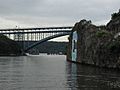
The "C" Rock, with the Henry Hudson Bridge behind it and the Spuyten Duyvil Bridge in the distance in the open position.

See also
 In Spanish: Río Harlem para niños
