
Manhattan Waterfront Greenway facts for kids
The Manhattan Waterfront Greenway is a special path for walking or cycling. It goes all the way around the island of Manhattan in New York City. This path is about 32 miles (51 km) long. It is a great place to enjoy the waterfront safely, away from cars. The largest parts of the Greenway are managed by the New York City Department of Parks and Recreation. Many sections keep walkers and cyclists separate for safety. The Greenway has three main parts: the East, Harlem, and Hudson River Greenways.
Contents
Exploring the Greenway's Paths
Hudson River Greenway: Manhattan's Longest Path


The Hudson River Greenway is the longest path in Manhattan. It runs along the West Side of the island. You can find it from Dyckman Street in the north down to Battery Park in the south. Most of this path goes through Riverside Park and Hudson River Park.
This part of the Greenway is the most used bike path in the United States! Most of it is close to the Hudson River. But north of the George Washington Bridge, the path climbs high. Here, you can find Inspiration Point. From this spot, you get amazing views of The Palisades in New Jersey and the George Washington Bridge.
The Hudson River Greenway is also part of two bigger trail systems. It is part of the East Coast Greenway, which is a 3,000-mile (4,800 km) trail connecting Maine to Florida. It is also the southernmost part of the statewide Empire State Trail.
At the south end, the Battery Bikeway connects the Hudson and East River Greenways. This path opened in 2015. If you want to go to Brooklyn, you can use bike lanes that connect to the Brooklyn Bridge.
A project called The Harbor Ring aims to create a 50-mile (80 km) bike route. This route would include parts of the Greenway along the Lower Hudson River and Upper New York Bay.
On October 31, 2017, there was a serious incident on a part of the Greenway. This event led to increased safety measures and a focus on keeping the path secure for everyone.
East River Greenway: Along the East Side

The East River Greenway runs along the East Side of Manhattan. It starts at Battery Park and goes past South Street Seaport. It ends at 125th Street in East Harlem. There is a gap of about 1.3 miles (2.1 km) in Midtown. Here, walkers and cyclists use busy streets to get around the United Nations Headquarters.
Some parts of this Greenway are narrow. For example, the Captain Patrick J. Brown Walk is very tight between the highway and a power plant. This means you need to go slower there. Other parts share space with cars that need to access places like Waterside Plaza. About a mile of the path is under the elevated FDR Drive. This section is being improved as part of the East River Esplanade project.
In 2008, the East River Greenway was a great spot to see the New York City Waterfalls art project.
The city and state have agreed to fund improvements for the gap in the Greenway between 38th and 60th streets. This will help make the path more continuous.
Harlem River Greenway: A Shorter, Continuous Path

The Harlem River Greenway is the shortest part of the Manhattan Waterfront Greenway. It is completely continuous, meaning it has no breaks. It runs north through lower Highbridge Park from 155th Street to Dyckman Street. This path is located between the Harlem River and Harlem River Drive.
If you are on the East River Greenway, you need to use regular streets through East Harlem to reach this section. A bike lane on Dyckman Street connects to Inwood Hill Park and the Hudson River Greenway.
There is also a second, shorter Harlem River greenway in Harlem River Park. This path runs from about 133rd Street to 145th Street. The city plans to extend this park south to 125th Street. This would allow it to connect to the East River Greenway.
Protecting the Greenway: The U-shaped Barrier Project
There are plans to build a new storm barrier along the southern part of the Greenway. This barrier will be U-shaped and will protect the city from storms. It will run between West 57th and East 42nd Streets.
This big project will include many features. Under the elevated FDR Drive near South Street, there will be special storm barriers. These barriers will hang from the highway's ceiling and can drop down when a storm is coming. There will also be a "Battery Berm" at Battery Park. A new maritime museum will open where an old Coast Guard building used to be.
The first part of this project is a 2.19-mile (3.52 km) barrier on the Lower East Side. It is called "The Bridging Berm." This berm will not only protect from storms but also offer a new path for walking and biking. It will have boating and fishing docks, and improved ramps for bridges. This new bikeway will create a second connection between the Hudson and East River Greenways. The total cost of this project is over $3.5 billion.
In March 2019, Mayor Bill de Blasio announced a bigger plan called the Lower Manhattan Coastal Resiliency Plan. This plan will create more barriers and might even extend the shoreline. This larger project is estimated to cost $10 billion. The city has already started putting up temporary barriers while the permanent ones are being built.
Images for kids
-
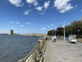
Tribeca pedestrian section through Hudson River Park
-
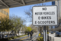
“NO MOTOR VEHICLES E-BIKES E-SCOOTERS” Sign posted on the Hudson River Greenway in New York City


See also
 In Spanish: Manhattan Waterfront Greenway para niños
