
Riverside Park (Manhattan) facts for kids
Quick facts for kids Riverside Park |
|
|---|---|

Riverside Park has many walking and bicycle paths.
|
|
| Type | Urban park |
| Location | Manhattan, New York |
| Area | 253.17 acres (102.45 ha) |
| Operated by | NYC Parks |
| Status | Open all year |
| Public transit access | Subway and bus; see below |
|
Riverside Park and Drive
|
|
| Location | From 72nd St. to 129th St., New York City |
| Built | 1874 |
| Architect | Multiple |
| NRHP reference No. | 83001743 |
| Significant dates | |
| Added to NRHP | September 2, 1983 |
Riverside Park is a beautiful public park in Manhattan, New York City. It stretches for about 4-mile (6.4 km) along the Hudson River. The park is located between the river (and the Henry Hudson Parkway) and a winding road called Riverside Drive.
The park was created in 1872. At first, train tracks blocked access to the river. But in the 1930s, a famous parks commissioner named Robert Moses led a big project. He had the train tracks covered. This created new land for the park and added many fun places to play.
Today, Riverside Park is part of the Manhattan Waterfront Greenway. This is a path for walking and biking all around Manhattan's waterfront. The park is managed by the New York City Department of Parks and Recreation. It is also a special historic place, listed on the National Register of Historic Places.
History of Riverside Park
How the Park Started
The land where Riverside Park now stands was once home to the Lenape people. Later, European settlers used it for farms and built homes. In 1846, the New York Central Railroad built train tracks along the river. This connected New York City to other places.
New York City grew very fast in the 1850s. Central Park was built nearby, which made people want more parks. In 1865, William R. Martin suggested building a park along the Hudson River. The idea was approved in 1866.
The first part of Riverside Park was bought in 1872. This also included building Riverside Avenue. This was a tree-lined road overlooking the future park.
Building the Park in the 1800s
_pg913_RIVERSIDE_PARK.jpg)
At first, Riverside Avenue was planned to be a straight road. But the land was hilly and difficult. In 1873, Frederick Law Olmsted was chosen to redesign the park and road. He also designed Central Park. Olmsted wanted the park to fit the natural landscape. He said the river bank was already beautiful with its trees and views.
Construction began around 1874. Other designers like Calvert Vaux helped shape the park. Riverside Avenue opened in 1880 and became very popular. However, the park was not fully finished. The train tracks still separated the park from the river.
People started to move to the area near the park in the 1880s. They formed a group to promote the park. But the park still had problems like trash and smoke from the trains.
In 1893, a plan was made to use the shoreline for the park. This allowed for future land to be added by filling in parts of the river. By 1895, more paths were built in the park.
Park Changes in the Early 1900s

Several important structures were built around 1900. Grant's Tomb was finished in 1897 at 120th Street. The Soldiers' and Sailors' Monument was built in 1902 at 89th Street. These monuments showed that the park was becoming more than just a nature space.
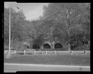
The park was also extended north. In 1898, a large bridge called the Riverside Drive Viaduct was built. It carried Riverside Drive over a valley to 135th Street. This bridge was finished in 1901. The park was extended to 158th Street by 1908.
In 1916, a group called the Women's League for the Protection of Riverside Park was formed. They wanted to make sure the park was used for fun activities. They were made up of wealthy families who lived near the park.
Robert Moses and the West Side Improvement

For many years, the New York Central Railroad tracks were a problem. They were noisy and dirty. People wanted the railroad to be moved underground. In 1913, the railroad suggested building a new tunnel. This plan was liked by many groups.
In the 1920s, there were many ideas for improving Riverside Park. Some plans included swimming pools and sports fields. They also suggested using dirt from subway construction to create new parkland.
In 1934, Robert Moses became the parks commissioner. He had a big vision for the park. He saw a long, dirty area that could be beautiful. He wanted to cover the train tracks and build a parkway along the river. This would become the Henry Hudson Parkway.
Moses's plan was called the "West Side Improvement." It involved building the Freedom Tunnel for the trains. On top of the tunnel, new parkland would be created. This plan also focused on adding many recreational areas. These included playgrounds, tennis courts, and pools.
Work began in 1935. The parkway was finished in 1937. The entire project was completed by 1941. It added 132 acres (53 ha) of new parkland. Eight playgrounds, baseball fields, and many other sports courts were built. The Women's League, having achieved its goal, closed down in 1937.
Park Decline and Restoration
After the 1940s, not many changes were made to the park. It started to be neglected. Vandalism and dumping became common. By the 1970s, the northern part of the park was in poor condition.
In 1979, a group called the Friends of Riverside Park was formed. They worked to plant trees and stop the park from getting worse. They also helped make Riverside Park a city landmark in 1980. It was listed on the National Register of Historic Places in 1983. This helped protect the park from future construction.
The city started to fix up parts of the park in the 1980s. But there was not enough money for full-time security or park rangers. In 1987, local groups created the Riverside Park Fund. They raised money for park maintenance. By the 1990s, they were doing many projects. These included new playgrounds and restoring old facilities.
The North River Wastewater Treatment Plant was built next to the park in the late 1980s. On top of this plant, the 28-acre (11 ha) Riverbank State Park opened in 1993.
Riverside Park South Expansion
.jpg)
In the 1980s, Donald Trump owned land south of Riverside Park. He wanted to build a huge development there. But many groups opposed his plans. In 1990, Trump agreed to a new plan with six community groups.
This new plan was called Riverside South. It included smaller buildings and a new park section. This new part, called Riverside Park South, stretches from 72nd to 59th Streets. It added 25 acres (100,000 m2) to Riverside Park. Old train yard parts, like Pier I, were included in the new park. A new bike path was also built to connect to Hudson River Park.
The first part of Riverside Park South opened in 2001. Other sections opened in 2003, 2006, and 2007. This project created a continuous path for walkers and bikers. It now runs almost the entire length of Manhattan.
Riverside Park in the 2000s
By the early 2000s, much of the park south of 125th Street was restored. But the northern section still needed work. In 2015, construction began on a new pedestrian bridge at 151st Street. This bridge opened in 2017. It made it easier for people from Hamilton Heights to reach the park.
In 2017, NYC Parks released a master plan for the park. It included restoring old structures and building new paths. However, the park still faces challenges. Drainage problems and decaying structures need fixing. A new bike bypass is being built to reduce crowding. The first part of this bypass opened in 2019.
Park Layout and Design
Riverside Park is a large park covering 253.17 acres (102.45 ha). The main part of the park is made of sloping areas. These are between the Henry Hudson Parkway and Riverside Drive, from 72nd to 125th Streets. This section is between 100 and 500 feet (30 and 152 m) wide.
The park has different levels or "tiers." The top level is Riverside Drive. Below that is a promenade on top of the train tunnel. The lowest level is the parkland next to the Henry Hudson Parkway and the waterfront. Each level has a different purpose. The top level borders the park. The middle levels have most of the green spaces, playgrounds, and sports areas. The bottom level offers views of the Hudson River and Palisades.
Before the park was built, the writer Edgar Allan Poe liked to sit on a rocky spot called "Mount Tom" at 83rd Street. This rock still exists in the park.
Paths and Trails
The park has many winding paths through its green areas. These paths connect to Riverside Drive and the waterfront.
The Riverside Walk is a path along the water. It runs the entire length of the park. Part of it is called Cherry Walk, between 100th and 125th Streets. It's named for the 700 cherry trees planted there in 1909.
Riverside Park also has a bicycle lane. However, it sometimes crosses pedestrian paths, which can cause crowding. So, a new bicycle bypass is being built in some areas.
Park Connections
Riverside Park South is an extension of the park from 72nd to 59th Street. It has an old train engine on display. Riverside Park South connects to Hudson River Park. This means you can walk or bike almost the entire length of Manhattan along the waterfront.
Paths also connect Riverside Park to Fort Washington Park to the north. This northern park includes Inspiration Point, a scenic spot at 190th Street.
Park Wildlife

Riverside Park is home to many animals, especially birds. A bird sanctuary is located between 116th and 124th Streets. Birdwatchers have seen over 177 different types of birds there. More than 80 bird species have been seen at the Bird Drip, a special water feature near 120th Street.
You can see many kinds of wildlife in the park. These include Canada geese, mallards, and American black ducks. You might also spot red-tailed hawks, American kestrels, and peregrine falcons. Other animals like raccoons and reptiles also live in the park. Sometimes, wild turkeys are seen, including one famous turkey named Giuliani.
Landmarks and Structures
Riverside Park has many interesting monuments and statues.
Monuments and Statues
- Amiable Child Monument: This monument is north of 122nd Street. It remembers a young boy named St. Claire Pollock who died in 1797. It's thought to be the only private grave on city land in New York City.
- Eleanor Roosevelt Monument: Located at 72nd Street, this statue honors Eleanor Roosevelt. She was a very important person who spoke up for human rights. The monument includes a quote from her speech at the United Nations.
- Firemen's Memorial: This memorial is at 100th Street. It honors firefighters and was built in 1913. It has a grand staircase and statues. There's even a tablet dedicated to the horses that helped firefighters.
- General Franz Sigel Statue: At 106th Street, this statue shows General Franz Sigel on horseback. He was a general in the Civil War.
- Grant's Tomb:

This large tomb is at 122nd Street. It is where President Ulysses S. Grant and his wife, Julia, are buried. It looks like an ancient building called the Mausoleum of Halicarnassus. It opened in 1897 and is a national monument.
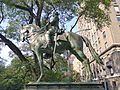
- Joan of Arc Memorial: This statue at 93rd Street shows Joan of Arc on horseback. It was created by artist Anna Hyatt Huntington and dedicated in 1915.
- Louis Kossuth Monument: This monument at 113th Street honors Hungarian leader Lajos Kossuth. It was dedicated in 1928.
- Soldiers' and Sailors' Monument:

This monument at 89th Street remembers Civil War veterans. It looks like an ancient Greek temple. It was dedicated in 1902 and is a New York City landmark.
- Warsaw Ghetto Plaza: This area between 83rd and 84th Streets remembers the heroes of the Warsaw Ghetto Uprising and the millions of Jewish people who died in World War II. A plaque was placed here in 1947.
- Other Monuments: The park also has memorials for the 1956 Hungarian Revolution, the Hippopotamus Fountain at 91st Street, and other important people.
Other Park Structures
Riverside Park has other buildings and features.
- 79th Street Boat Basin and Rotunda:

The 79th Street Boat Basin is a place where boats can dock. It has 116 slips for boats. Next to it is the 79th Street Rotunda. This is a three-story circular building that helps cars get to the Henry Hudson Parkway and the park. Inside the rotunda, there's an open-air cafe.
- 102nd Street Field House: This building was completed in 1937. It was renovated in 2015.
- Peter Jay Sharp Volunteer House: Located at 107th Street, this building is used by the Riverside Park Conservancy. It has space for volunteers, plant-growing areas, and meeting rooms.
Activities in Riverside Park
Riverside Park offers many fun things to do! It has courts for tennis, volleyball, and basketball. There are also soccer fields and a skatepark.
Play Areas for Kids and Dogs
Riverside Park has several playgrounds for children:
- Little Engine Playground (67th and 68th Streets)
- Classic Playground (74th Street)
- Neufeld Playground (76th Street)
- River Run Playground (83rd Street)
- Hippo Playground (91st Street)
- Dinosaur Playground (97th Street)
- 101st St. Soccer Field (101st Street)
- Claremont (124th Street)
- Riverside Park (119th Street)
There are also "Tot Lots" for younger children:
- Tot Lot One Hundred Five (105th Street)
- Tot Lot One Hundred And Ten (110th–111th Streets)
- Tot Lot One Hundred And Twelve (112th–113th Streets)
- Tot Lot One Hundred And Sixteen (116th–117th Streets)
If you have a dog, there are three dog runs at 72nd, 87th, and 105th Streets.
The park also has the Riverside Skatepark at 109th Street. It was the first large public skatepark in Manhattan, built in 1995.
Sports and Recreation

You can find many sports facilities here:
- Baseball fields: Nine fields, including five standalone fields and two pairs that overlap with other sports fields.
- Basketball courts: Five sets of courts.
- Handball courts: Seven courts.
- Tennis courts: 20 courts.
- Soccer fields: Six fields.
- Volleyball courts: Courts at 102nd, 105th, and 148th Streets.
Many of these facilities were built during the park's big reconstruction in the 1930s.
The park hosts a free event series called "Summer on the Hudson" from May to October. It includes movies, concerts, and shows for children. Besides the 79th Street Boat Basin, there's a kayak launch at 148th Street. You can also rent kayaks for free at 72nd Street during spring and summer.
Park Management
The Riverside Park Conservancy is a non-profit group that helps take care of the park. While NYC Parks owns and runs the park, the Conservancy helps maintain and restore it. They also provide educational and cultural programs.
The Riverside Park Fund was started in 1987. It was a community group that wanted to improve the park. They created community gardens and helped with maintenance. In 2012, the Fund changed its name to the Riverside Park Conservancy. As of 2018, the Conservancy has 30 staff members. They work on gardens, playgrounds, sports fields, and other park projects.
Robert M. Morgenthau Citizenship Award
The Riverside Park Conservancy created an award in 2016. It's called the Robert M. Morgenthau Citizenship Award. It honors people who have done great things for the park and the community. It's named after Robert Morgenthau, a former district attorney.
Transportation to Riverside Park
It's easy to get to Riverside Park using public transportation.
You can take the subway to many stations near the park on the IRT Broadway–Seventh Avenue Line (1 2 3 trains). These include:
- 72nd Street
- 79th Street
- 86th Street
- 96th Street
- 103rd Street
- Cathedral Parkway–110th Street
- 116th Street–Columbia University
- 125th Street
- 137th Street–City College
- 145th Street
You can also take the M5, M11 buses along Riverside Drive. Many other bus routes also stop close to the park.
Images for kids
-
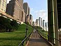
Ramp in Riverside Park looking up to W 68th Street
-
General Franz Sigel memorial
-
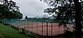
96th Street Clay Tennis Courts


See also
 In Spanish: Riverside Park para niños
