Spuyten Duyvil Creek facts for kids
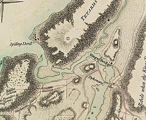
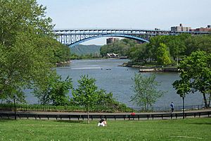
The Spuyten Duyvil Creek is a short waterway in New York City. It connects the Hudson River to the west with the Harlem River Ship Canal, which then leads to the Harlem River. These waterways together separate the island of Manhattan from the Bronx and the rest of the mainland. The creek used to be a wild, fast-moving stream. Today, it is part of the wider ship canal.
The neighborhood of Spuyten Duyvil in the Bronx is located north of the creek. The Marble Hill neighborhood in Manhattan is also north of the Ship Canal.
Contents
What Does "Spuyten Duyvil" Mean?
- Further information: Spuyten Duyvil, Bronx#Etymology
The name "Spuyten Duyvil" was first used in 1653. It appeared in a document from a Dutch landowner named Adriaen van der Donck. The name comes from the Dutch words Spuitende Duivel. This can be translated as "Spouting Devil" or "Spewing Devil." It describes the strong and wild water currents found there. Some people also translate it as "Devil's Whirlpool."
A popular story about the name comes from Washington Irving's book A Knickerbocker's History of New York (1809). The story says the name means "to spite the Devil." It tells of a trumpeter named Anthony Van Corlaer. He tried to swim across the dangerous creek to warn settlers about a British attack.
Native American tribes, the Lenape, had their own names for the creek. One name was Shorakapok, meaning "the sitting down place." Another name was Paparinemo, which meant "place where the stream is shut" or "to divide." They also used the name Muscoota.
History of the Creek
Early Days of the Creek
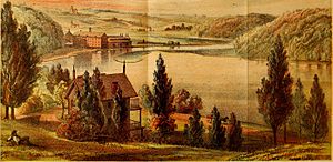
Spuyten Duyvil Creek was originally a narrow waterway. It connected the Hudson River to the west and the Harlem River to the east. The Dutch settlers found its strong tides hard to navigate. The creek was also fed by Tibbetts Brook, which flowed south from Yonkers. Today, Tibbetts Brook flows underground into sewers.
In the 1600s, people crossed the Harlem River by ferry. This ferry was run by Johannes Verveelen. Many people avoided paying the ferry toll by wading or swimming across the creek. This spot was known as the "wading place." It was located between northern Marble Hill and modern Kingsbridge, Bronx. Verveelen tried to block the wading place, but people kept tearing down his fences.
Building Bridges Across the Creek
In 1693, a Dutch nobleman named Frederick Philipse built the King's Bridge. This bridge was near what is now West 230th Street in the Bronx. Philipse owned a lot of land in the area. His toll bridge helped people travel and settle his land. It later became part of the Boston Post Road.
Later, in 1758, another bridge called the Free Bridge was built. This bridge was free to use and took away much of the traffic from King's Bridge. The Free Bridge was destroyed during the American Revolution. After the war, King's Bridge also became free to use.
The Harlem River Ship Canal
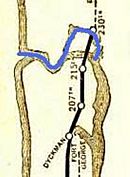
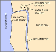
Over time, people wanted to make it easier for ships to travel between the Hudson and Harlem Rivers. The creek was too narrow and winding for large ships. So, a plan was made to dig a wide shipping canal. This canal would go straight through the land, avoiding the big bend around Marble Hill.
Construction of the Harlem River Ship Canal began in January 1888. It was also called the United States Ship Canal. The canal was planned to be 400 feet wide and 15 to 18 feet deep. It would cut directly through the rock. The first part of the canal, the cut at Marble Hill, was finished in 1895. It opened on June 17, 1895, with celebrations and parades.
When the canal was built, it physically separated Marble Hill from Manhattan. The old creek bed was filled in with rock in 1914. This rock came from digging the foundation for Grand Central Terminal. This made Marble Hill physically connected to the Bronx. However, it still remains part of Manhattan today.
In 1919, New York State decided to straighten the western end of the creek near the Hudson River. This part of the creek used to curve around a factory called Johnson Iron Works. The factory eventually moved in 1923. The new, straight channel was dug from 1937 to 1938. This work cut off the factory's land from the Bronx. This land then became part of Inwood Hill Park in Manhattan.
Today, Spuyten Duyvil Creek, the Harlem River Ship Canal, and the Harlem River are all connected. They are often called the Harlem River. The Broadway Bridge still connects Marble Hill with Manhattan.
Bridges Over the Creek
Three main bridges cross the Spuyten Duyvil Creek:
- The Spuyten Duyvil Bridge is a railroad bridge. It swings open to let boats pass. This bridge carries Amtrak trains between Penn Station in New York City and Albany. It opened in 1900.
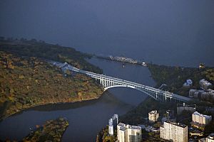
- The Henry Hudson Bridge is a large steel arch bridge. It has two levels and carries the Henry Hudson Parkway (NY 9A). People pay a toll to cross this bridge. It was first planned in 1904 but was not finished until 1936.
- Broadway Bridge is a vertical lift bridge. This means a section of the bridge lifts straight up to let ships pass. It carries cars and people on its lower level (US 9). The New York City Subway's 1 train trains run on its upper level. The current bridge opened in 1962.
See also
 In Spanish: Arroyo Spuyten Duyvil para niños
 | Shirley Ann Jackson |
 | Garett Morgan |
 | J. Ernest Wilkins Jr. |
 | Elijah McCoy |


