
Bergen Neck facts for kids


Bergen Neck is a special piece of land in New Jersey. It's a peninsula, which means it's land almost completely surrounded by water. This area is located between two large bodies of water: the Upper New York Bay and the Newark Bay.
Bergen Neck is part of Hudson County. It includes parts of two cities: Bayonne and Jersey City. The very southern tip of this peninsula is called Bergen Point. It's separated from Staten Island by a narrow waterway called the Kill Van Kull. You can cross this waterway using the Bayonne Bridge.
Contents
A Look Back in Time
How Bergen Neck Got Its Name
People probably started calling this area "Bergen Neck" in the 1600s. This was when the first Dutch and English settlers arrived. They explored the land between the bays and along the Hudson River and Hackensack River.
Even though it's now in Hudson County, this area used to be part of Bergen County. Bergen County was created in 1683. Later, in 1840, Hudson County was formed. Bergen Neck was also part of a larger area called Bergen Township until 1862.
Old Names for the Peninsula
The Dutch settlers first called this land "Oyster Island." They thought it was an island at first! After the British took over in 1674, it was briefly known as "Old Hackensack Neck."
During the American Revolution, British maps showed it as "Barren Neck." Today, the name "Bergen Neck" isn't used as much. People sometimes call it the Bayonne Peninsula, Hudson Peninsula, or South Hudson.
A Fort from the Revolution
Bergen Neck was home to a fort built in 1776 during the American Revolution. British soldiers took over the fort in 1777. They renamed it Fort Delancey after Oliver De Lancey, Sr. The fort was taken down in September 1782.
The name "Bergen Neck" still lives on in the First Reformed Dutch Church of Bergen Neck in Bayonne.
Waterways and Transportation
The edges of Bergen Neck that meet the water are very different from each other.
Rail Lines and Bridges
Years ago, the Central Railroad of New Jersey had a bridge called the CRRNJ Newark Bay Bridge. This bridge crossed the Newark Bay and led to a train station called Communipaw Terminal. Parts of these old train lines are now used by the Hudson Bergen Light Rail, which is a modern train system.
Another important train line, the National Docks Secondary, is now used by Norfolk Southern. It helps move goods to places like Port Jersey.
Bergen Hill
The Hudson Palisades are tall cliffs that appear on Bergen Neck. This part is called Bergen Hill. Train lines also go through this area.
Industry and Parks
Busy East Side
During the 1900s, the eastern side of Bergen Neck was a very busy place. It had many large factories, train yards, and shipping docks. There were also military bases. Some famous companies and places included Standard Oil, the Central Railroad of New Jersey, and the Military Ocean Terminal at Bayonne.
Some areas, like Constable Hook and Port Jersey, are still used for shipping and industry today. However, other old industrial sites, called "brownfields," have been cleaned up. They are now used for homes, shops, and fun places like Liberty State Park.
Residential West Side
The western side of Bergen Neck, which faces the Newark Bay, has traditionally been more residential in Bayonne. This means more homes and neighborhoods. In Jersey City, the west side is a mix of things. You'll find homes, stores, city services, factories, and parks like Lincoln Park.
Public Water Access
There are projects underway to help people get closer to the water. These include creating the Hudson River Waterfront Walkway and the Hackensack RiverWalk. These walkways let people enjoy the views and nature along the water's edge.
Images for kids
-
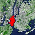
Bergen Neck lies to the west of the Upper New York Bay, shown in red.
-
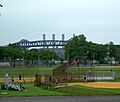
Lincoln Park, Jersey City
