
Governors Island facts for kids
|
Paggank
Noten Eylandt Nutten Island |
|
|---|---|

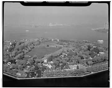
Governors Island viewed from One World Trade Center in 2017
|
|
| Etymology |
|
| Geography | |
| Location | New York Harbor |
| Coordinates | 40°41′29″N 74°0′58″W / 40.69139°N 74.01611°W |
| Area | 172 acres (70 ha) |
| Highest elevation | 70 ft (21 m) |
| Highest point | Outlook Hill |
| Administration | |
| State | New York |
| City | New York City |
| Borough | Manhattan |
| Demographics | |
| Population | 0 (2010) |
| Additional information | |
| Time zone | |
| • Summer (DST) | |
| ZIP Code | 10004 |
| Official website | The Trust for Governors Island website The Governors Island National Monument website |
|
Governors Island
|
|
| Location | New York City, New York, U.S. |
| Area | 172 acres (70 ha) |
| Architectural style | Colonial Revival, Greek Revival |
| Visitation | 800,000 (2018) |
| NRHP reference No. | 85002435 |
| Significant dates | |
| Added to NRHP | February 4, 1985 |
| Designated NHL | February 4, 1985 |
| Designated NMON | January 19, 2001 |
Governors Island is a 172-acre island in New York Harbor. It is part of the Manhattan area of New York City. The island is about 800 yards south of Manhattan and is separated from Brooklyn by the 400-yard-wide Buttermilk Channel.
A small part of the island's north end is managed by the National Park Service. This area is called the Governors Island National Monument. It includes two old military forts: Fort Jay and Castle Williams. The rest of the island, about 150 acres, is a public park run by The Trust for Governors Island. This park has 52 historic buildings. About 103 acres of the island were created by adding land in the early 1900s.
The native Lenape people called Governors Island Paggank, which means "nut island." This was because of the many nut trees like chestnut, hickory, and oak. They likely used the island for hunting and gathering food. The Dutch later called it Noten Eylandt, which became Nutten Island in English. By the late 1700s, it was known as "Governor's Island." This name came from the time when the island was set aside just for New York's royal governors.
Governors Island has been used by the military since 1776, during the American Revolutionary War. American troops built defenses there. From 1783 to 1966, it was a United States Army base, mainly for training soldiers. It also served as an important defense point during wars. After that, it was a major United States Coast Guard base until 1996. The island was then sold to the public in 2003 and opened for visitors in 2005.
Today, Governors Island is a very popular place, with over 800,000 visitors each year. Besides the 43-acre public park, it offers free arts and cultural events, plus fun activities. The New York Harbor School, a public high school focused on sea-related studies, has been on the island since 2010. You can only get to the island by ferry from Brooklyn and Manhattan. There are no full-time residents living there. Until 2021, it was only open in the summer, but now it's open all year.
Contents
Island Names and Their Meanings
The native Lenape people had several names for the island, like Paggank. All these names mean "Nut Island." This is because many chestnut, hickory, and oak trees grew there. The Dutch explorer Adriaen Block called it Noten Eylandt, which was a direct translation. This name later became Nutten Island in English.
The name "Governor's Island" (with an apostrophe) came from the time when the British ruled New York. The island was kept just for the royal governors of New York. In 1784, the apostrophe was dropped, and it became "Governors Island," which is its official name today.
Island History
Early Days and European Arrival
_WIC_1624.jpg)
Governors Island used to be much smaller than it is now. It had many small bays and lots of hardwood trees, which is where its original name came from. We don't know for sure if the Lenape people lived there permanently or just used it for hunting and gathering food.
In 1524, Giovanni da Verrazzano might have been the first European to see the island, then called Paggank. One hundred years later, in May 1624, the first Dutch settlers in New Netherland landed on Noten Eylandt. They came from Amsterdam on the ship Nieu Nederlandt to claim the New Netherland territory. Because of this, the New York State government recognizes Governors Island as the birthplace of New York State.
In 1633, Wouter van Twiller, a Dutch leader, took over the island for his own use. He started a farm there and even built a windmill. After he left in 1642, the island was used by the Dutch for recreation.
British Control and the American Revolution
New Netherland became English territory in 1664 and was renamed New York. By 1674, the British fully controlled the island. The shallow water between the island and Brooklyn became known as Buttermilk Channel. This was because farm women used it to row boats to Manhattan to sell buttermilk. By 1680, Nutten Island had one house and was used by colonial governors to raise animals.
The British started calling it "Governor's Island" in 1698 and kept it just for the governors. Some governors built mansions or used it for hunting. For a short time around 1710, it was even a place where German refugees had to stay before moving on. The island mostly stayed quiet until the American Revolutionary War began in 1775.
Governors Island in the American Revolution
.jpg)
Plans to build forts on Governor's Island were made as early as 1741, but nothing was built then. The island was first used by the military in 1755 during the French and Indian War. British soldiers camped there, and by the mid-1760s, there was a fort and other defenses.
When the American Revolution started, General George Washington ordered defenses to be built on Governor's Island. On April 9, 1776, American troops added earthworks and 40 cannons. On July 12, 1776, these defenses fired at British ships trying to sail up the Hudson River. The forts helped Washington's army escape from Brooklyn after the Battle of Long Island in August 1776.
After the Americans left, the British took back Governor's Island. From September 2 to 14, 1776, the British on the island exchanged fire with American cannons in Manhattan. On September 6, the Americans tried to use the first-ever submarine, the Turtle, to attack a British ship near the island, but it didn't work. The British held the island and New York City until 1783.
From Military Base to Public Park
After the Revolution and New Forts
After the American Revolution, Governors Island became part of New York State. It was used as a hotel and a racetrack, and the old forts fell apart. The island's name was officially changed to "Governors Island" in 1784.
.jpg)
By the 1790s, people wanted to build stronger forts to protect New York Harbor. Governors Island was chosen as one of the first places for new defenses. The island was given to the federal government in 1800.
Fort Jay was rebuilt between 1806 and 1809 into its current five-pointed star shape. It was first called Fort Columbus. A second major fort, Castle Williams, was built from 1807 to 1811 on the northwest side of the island. It was a round fort. A third fort, the South Battery, was built in 1812. These forts were ready for the War of 1812, but they never saw combat.
Mid-1800s and the Civil War
After the War of 1812, Governors Island became a place for troops to live. The New York Arsenal, which handled military weapons, moved to the island in 1832. Many new buildings were constructed for the Army, including officers' homes and a hospital. The Admiral's House, built in 1843, is an example of the Greek Revival style used for these buildings.

During the American Civil War, Governors Island was used to gather soldiers. The forts were still active. Castle Williams held Confederate Army prisoners of war, and Fort Columbus held captured Confederate officers. In 1863, during the New York City draft riots, protesters tried to take over the island, but they failed.
After the war, Castle Williams became a military prison. New officers' homes were built in Nolan Park. The island also had a cemetery, but all the bodies were moved by 1886. In 1885, the first solid waste incinerator in the U.S. was built on the island. In the late 1800s, some people wanted to turn Governors Island into a public park, but this plan didn't happen.
Island Expansion and World War I

The Army decided to make the island bigger in the late 1800s. They used dirt and rock dug out from the first New York City Subway lines. This work was mostly finished by 1913. It added 103 acres to the island, making its total area 172 acres.
The new southern part of Governors Island was first used as an airstrip. In 1909, Wilbur Wright made the world's first flight over water from Governors Island. The next year, Glenn Curtiss landed there after flying from Albany. An aviation training center even operated there from 1916 to 1917.
During World War I, many temporary buildings were put up on the island. The new southern section held warehouses with $75 million worth of supplies. All these buildings were connected by the 8-mile-long Governors Island Railroad. This railroad was later called the "World's Shortest Railroad" before it was removed in 1931.
Mid-1900s and Coast Guard Era

After World War I, Governors Island became the headquarters for the Second Corps Area of the Army. In 1927, General Hanson Edward Ely started a big building program. New buildings included a movie theater, a YMCA, and an "officer's club." Liggett Hall, a huge military barracks, was built in 1928 and was one of the largest barracks in the world.
.jpg)
During the 1930s, the Works Progress Administration (WPA) improved much of the island, hiring up to 5,000 workers. They restored buildings and improved the land. The island's roads were also paved for modern vehicles.
Governors Island became a lively Army community. It had three chapels, a movie theater, and a YMCA. Sports like polo and golf were popular. A golf course was built inside Fort Jay, sometimes called the "world's crookedest" course. There were also tennis courts and swimming pools. A Roman Catholic church was built in 1942, and a synagogue in 1959.
During World War II, Governors Island became a major administrative center. It was the headquarters for the U.S. First Army. It also became a U.S. Army recruitment center in 1941, processing 1,500 recruits daily.
From Army to Coast Guard

In 1964, the U.S. government decided to close many military bases to save money, including Fort Jay. In 1965, the United States Coast Guard asked to move to Governors Island. They wanted to bring all their New York City facilities to one place.
On December 31, 1965, the Army base officially closed, and Governors Island became a Coast Guard base. It became the Coast Guard's largest base. By 1985, about 4,000 Coast Guard members and 1,000 family members lived there. The Coast Guard built new apartment buildings and a boat marina. Liggett Hall was turned into classrooms. The island had its own fire and police departments, banks, stores, churches, a school, a movie theater, and even a Burger King.

Many important events happened on Governors Island during the Coast Guard era. In 1986, President Ronald Reagan visited for a ceremony to relight the Statue of Liberty. In December 1988, Reagan and President-elect George Bush met with Soviet leader Mikhail Gorbachev on the island. In 1993, the United Nations held talks there that led to the Governors Island Accord.
In 1995, the Coast Guard decided to close the base to save money. By 1996, all Coast Guard operations and people had moved off the island. President Bill Clinton offered to sell the island to New York City for just $1 if it would be used for public purposes.
Redevelopment for Public Use
After the Coast Guard left, many ideas were proposed for Governors Island. Some suggested a casino, a hotel, a museum, a public park, or an educational campus. In 2000, the city and state agreed to keep the island for public use.

In 2001, President Clinton made 22 acres of the island, including Fort Jay and Castle Williams, a Governors Island National Monument. This part would be managed by the National Park Service. In 2003, the rest of the island (150 acres) was sold to a city-state agency for $1. The agreement said no permanent homes or casinos could be built there. It also required 40 acres to be parkland and 50 acres for "educational, civic or cultural" uses.
The island opened to the public in 2005, with 8,000 visitors that year. At first, it was only open on summer weekends. Free bikes and ferry services were offered to attract more people.
Creating the New Park

In 2007, a design team called West 8 won a competition to create a new park on the island. Their plan included 87 acres of open space, restoring the historic area, and building a new park on the southern part of the island with artificial hills.
In 2010, the city took full control of the island's development. Construction on the $260 million park began in May 2012. The old Coast Guard housing was taken down.
As part of the first phase, Soissons Landing was improved with new ferry docks. The Parade Ground was made ready for lawn sports. In 2014, Liggett Terrace courtyard was built, along with Hammock Grove and a new play area. The Oyster Pavilion opened in 2015, and the 10-acre Hills section of the park opened in 2016. The island became much more popular, with over 800,000 visitors in 2018.
Recent Changes and Future Plans
In 2018, New York City Mayor Bill de Blasio proposed changing the rules for the undeveloped parts of Governors Island. This would allow for dorms, offices, or educational buildings. Some people were against this, wanting the island to stay mostly as it is.
The Lower Manhattan Cultural Council's Arts Center opened in September 2019. It's in a renovated old warehouse and has galleries, exhibition space, and studios for artists. Other year-round groups on the island include Billion Oyster Project and the New York Harbor School. In October 2019, city officials suggested building a climate change research center on the island.
In September 2021, Mayor Bill de Blasio announced that Governors Island would be open all year, instead of just from May to October. In March 2022, the QC NY spa opened in an old barracks. In April 2023, Stony Brook University was chosen to build a 400,000-square-foot climate research lab on the island. This lab is planned to cost $700 million and open in 2028.
Island Geography
Governors Island has 172 acres of land. About 22 acres are managed by the National Park Service, and the rest by The Trust for Governors Island. The island is about 400 yards west of Brooklyn and 800 yards south of Manhattan. It is part of Manhattan and shares the ZIP Code 10004. The island has several named streets, mostly in the northern part, and a path around its edge.
Governors Island looks a bit like an ice cream cone. The 69-acre northern part is the original land, like the "ice cream." The 103-acre southern part was created by adding land, like the "cone." Division Road and Liggett Hall divide the island, separating the National Park Service area from the parkland in the south.
The highest natural point on Governors Island is 40 feet above the water, near Fort Jay. The southern section used to be low, but since the new park was built in the 2010s, it has hills ranging from 26 to 70 feet high. This construction also helped protect the island from climate change, like raising parts of the south island out of flood zones. However, a 2023 study found that Governors Island is sinking about 3.4 millimeters per year, mainly because the southern part was built on added land.
Important Structures
Forts and Defenses

Several forts were built on Governors Island to protect New York Harbor. These forts worked with others like Castle Clinton in Manhattan and Fort Wood on Liberty Island. They were meant to protect the city during the War of 1812.
Fort Jay, in the middle of the original northern part of the island, is the oldest, built in 1794. It was built on the highest point, with a grassy slope around it. The original fort was replaced in 1806. The rebuilt fort, which was called Fort Columbus for a while, had a five-pointed star shape and could hold 100 cannons. Its current look is mostly from renovations in the 1830s. Fort Jay's walls are made of sandstone and granite, and it has a dry moat around it.
Castle Williams was built from 1807 to 1811 on the northwest corner of the island. It's a round, four-story sandstone building, 40 feet high and 210 feet wide. Its walls are 8 feet thick at the bottom and 7 feet thick at the top. Each floor had 13 openings for cannons, for a total of 104 cannons.
A third fort, the South Battery, was built on the southeast corner of the original island before the War of 1812. This fort had 13 cannons facing Buttermilk Channel. It was later used as an officers' club.
Open Spaces
Northern Area Parks

There are four main open areas in the historic northern part of Governors Island. The northernmost is the grassy slope around Fort Jay, called the glacis. This area was once a polo field and part of the Governors Island Golf Course.
Southeast of Fort Jay is Nolan Park. This is a formal, tree-lined area surrounded by old officers' homes and offices. Its design dates back to the 1870s and it's named after Major General Dennis E. Nolan.
Governors Island's Parade Ground is west of Nolan Park and south of Fort Jay. It's about 13 acres. This area was used for military training and also for executions. Today, it's a large open space. Near the Parade Ground, there's New York City's only lavender field.
The fourth open space is a triangle between Clayton and Hay Roads, also known as Colonels Row Green. It was created in the early 1900s.
Southern Area Parks

The southern part of Governors Island has a park that covers more than 43 acres. The north end of the park has Hammock Grove, a landscaped area with rolling hills and over 60 types of trees. This grove is 10 acres and has 50 hammocks. Next to it is the 14-acre Play Lawn, with two fields for baseball. The paths in this part of the island wind around, like in Central Park, to make it feel peaceful.
.jpg)
The south end of the park has the Hills section, which covers 10 acres. The Hills are four man-made hills, from 26 to 70 feet high. They were built using materials from old buildings on the island. Each hill has a path to its top.
- The 26-foot Grassy Hill.
- The 40-foot Discovery Hill, with special artwork.
- The 40-foot Slide Hill, which has four long slides.
- The 70-foot Outlook Hill, which has a viewing area at the top with amazing views of New York Harbor, Lower Manhattan, and Brooklyn.
The Hills have over 41,000 shrubs and 860 new trees. This project cost $70 million.
At the very south tip of Governors Island is Picnic Point. This area has grills and picnic tables right by the water.
Other Buildings
When the Coast Guard left in 1996, Governors Island had 49 buildings built before 1917 and 121 built after 1917. The southern part was mostly for homes and industry, while the northern part had a mix of uses.
Homes and Quarters
Governors Island has several groups of low-rise officers' homes. Most are empty now, but some are used for exhibits or offices. The two largest groups of homes in the historic northern part are Colonel's Row and the buildings around Nolan Park.


Nolan Park has several historic buildings. The Admiral's House (building 1), a two-story brick house built in 1843, is a city landmark. The Governor's House (building 2), a two-story brick house built around 1805–1813, is also nearby. The Block House (building 9), built in 1843, was first a hospital and later offices. Other buildings in Nolan Park were officers' quarters.
Colonel's Row has eight individual officers' homes. The first ones were built in 1893-1895. Building 409, a Colonial Revival style building, was completed in 1910 for unmarried officers.

On the southwest side of Colonel's Row is Liggett Hall (building 400). This three-to-four-story barracks is almost the entire width of Governors Island, measuring 1,023 feet long. Built in 1930, it was one of the largest military barracks in the world. Two similar buildings, building 550 (now the New York Harbor School) and building 333, are next to Liggett Hall.
Many of the old homes in Nolan Park and Colonels Row are now used by arts and culture groups. They offer free programs for visitors. During the 2020 season, many of these homes were used as free workspaces for artists.
The southern half of Governors Island used to have residential apartment buildings up to 11 stories tall. The largest, the 11-story Cunningham Apartments (building 877), was built in 1968 and was taken down in 2013.
Places of Worship

Religious services on Governors Island started with the first chapel in 1846. Later, there were three places of worship. The Chapel of St. Cornelius the Centurion (building 13), a two-story stone building, was built in 1907.
A Catholic church called Our Lady, Star of the Sea, was built in 1942. A synagogue called Congregation Shaare Shomayim was built in 1960.
Offices and Storage
Several buildings were part of the Arsenal and used for offices or storage. These include buildings 104, 107 (storehouses), 105 (armory and office), and 110 (quartermaster's depot). Building 110 is now the Lower Manhattan Cultural Council's Arts Center. These buildings were built of brick from the 1850s to 1870s. Pershing Hall (building 125), a three-story brick building, was the headquarters for the First Army when built in 1934.
Other Service Buildings

The northwest side of the island has building 515, the old Post Hospital. It was built in 1935. Nearby is the Tampa Memorial Library (building S-251), a one-story wooden building built in 1908.
Near the South Battery, building 301 housed an elementary school called PS 26. Building 324 was built in 1926 as the Army YMCA. The War Department Theater (building 330), a two-story theater with 700 seats, was built in 1937–1939.
An old motel (building 293) near the South Battery was taken down in 2007–2008 to make the Parade Ground bigger. Building 785 on the southern part of the island used to have a fast-food restaurant and a bowling alley.
Monuments
The Monumental Setting for Bronze Plaque, a brick bench, was built in 1938. The Early Birds Monument, dedicated in 1954, is a bronze propeller on a granite base. It celebrates early aviation on the island.
How the Island is Managed

Three groups work together to take care of Governors Island: the National Parks of New York Harbor Conservancy, the Trust for Governors Island, and Friends of Governors Island.
National Parks of New York Harbor Conservancy
This non-profit group manages the 22 acres of the Governors Island National Monument. They work with the National Parks of New York Harbor (part of the National Park Service).
Trust for Governors Island
This non-profit organization is part of the city government. It is in charge of planning and managing the redevelopment of the other 150 acres of the island. The Trust also organizes public art displays on the island.
Friends of Governors Island
This private non-profit group manages the island's daily operations and programs. It started in 1995 to help bring the island back to New York for public use. The Friends run volunteer programs, raise money, and speak up for the island.
Working Dogs
Governors Island uses working dogs to chase away Canada geese. These dogs help keep the island clean and safe from the large groups of geese that visit. Before the dogs, other methods like remote-control cars and lasers didn't work. The dogs help protect other birds and visitors, as geese can be aggressive during nesting season. The Working Dogs program started in 2015 with Max, a Border Collie.
As of 2019, the Governors Island working dog team has four dogs: Max, Quinn, Chip, and Aspen. These dogs are popular on social media and also act as friendly ambassadors to visitors.
Cannonball Discoveries
Most of the cannonballs and shells from the island's military past were removed by the 2000s. In 1900, the government sold over 5,000 tons of cannonballs to be melted down. More were sold in 1942 to help with World War II manufacturing. Cannonballs are still found sometimes, like a 350-pound one found in 2012. You can see some inactive cannonballs near Fort Jay.
Fun Activities

Governors Island offers many activities, including free National Park Service tours of the monument, bike riding, picnics, art shows, fairs, festivals, and concerts. The northern half has the historic areas, and the southern half has the 43-acre park.
Regular Activities
Many free activities are offered. The houses in Nolan Park and Colonels Row host art, culture, and education exhibits. Downtown Boathouse offers free kayaking. There are also walking tours of the island's historic landmarks. Other programs include an adventure playground called The Yard, a compost site, and a teaching garden. The American Indian Community House uses the Admiral's House for exhibitions and cultural programs.
Some activities cost money. QC NY, a spa, has heated pools and saunas. Collective Retreats offers "glamping" (glamorous camping). Blazing Saddles rents bikes and pedicabs, and there are Citi Bike stations.
Special Events

Many events happen on Governors Island, like outdoor movies, food and art festivals, runs, concerts, and a pumpkin patch in October. Governors Island Arts presents art and public programs. They choose organizations each year to offer activities. The New York City Poetry Festival is also held there every year.
Concerts are common, like the free Rite of Summer Festival. The Jazz Age Lawn Party, a two-day event where people dress up in 1920s clothes, is also hosted on the island. In September 2019, the Longines Global Champions Tour, a horse jumping competition, came to Governors Island.
Past events include a Dutch festival and a French carnival with old rides. The Governors Ball Music Festival started on the island in 2011 before moving to Randalls Island. The Governors Island Art Fair also took place annually from 2008 to 2023.
Getting to the Island
As of 2021, Governors Island is open all year, from 7 a.m. to 6 p.m. seven days a week. Until 2015, it was only open on summer weekends.
Ferry History
The first public boat service to Governors Island started in 1794. The Army later took over, using barges from South Ferry in Manhattan. Steamboat service began in 1844. By 1897, the ferry service was improved for the growing Army presence. New ferryboats that could carry 823 passengers and 21 cars were added in 1925–1929.
Public ferry access from Manhattan started in 2005. In 2010, weekend ferry service began from Brooklyn Bridge Park. In 2017, this route became part of NYC Ferry's East River route. A new 400-person ferry, Governors 1, was added in 2019.
Current Ferry Services

Governors Island has two ferry landings: Soissons Landing and Yankee Pier. Soissons Landing, on the north shore, has two docks built in 1947. Ferries from here go to the Battery Maritime Building in Manhattan's Financial District. The ride takes about 7 minutes. These ferries run daily when the island is open.
Ferries also go to Yankee Pier on the southeast side. One route, run by The Trust, goes to Red Hook on weekends. The second route is the Governors Island route by NYC Ferry. During summer weekends, it goes to Pier 11/Wall Street in Manhattan. From November 2021, NYC Ferry's South Brooklyn route also serves Yankee Pier during winter and on summer weekdays.
The Trust's ferries run every half hour. As of 2022, a round-trip fare is $4 per person, but children, seniors, and some groups ride for free. There's no charge on weekend mornings. NYC Ferry services also run every half hour and cost $2.75 for a one-way trip.
The main ferryboat for the Trust is the Samuel S. Coursen, built in 1956. A second vessel, Governors 1, started service in 2019. As of 2023, the Trust is replacing the Coursen with a new electric ferry.
Notable People
- Neal Adams (1941–2022), comic book artist; born on the island.
- Withers A. Burress (1894–1977), commanding general during World War II; finished his career as commander of the First United States Army at Fort Jay.
- Winfield Scott Hancock (1824–1886), U.S. Army officer and presidential candidate; died on the island.
- Peter Marzio (1943–2010), former director of Museum of Fine Arts, Houston.
- Smothers Brothers (Tom Smothers born 1937 and Dick Smothers born 1939), entertainers; born on the island.
Images for kids
-
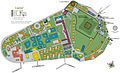
Map showing Coast Guard usage of Governors Island in 1995
-
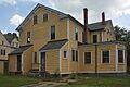
A two-and-a-half-story yellow house in Nolan Park


See also
 In Spanish: Governors Island para niños
