
Brooklyn Bridge Park facts for kids
Quick facts for kids Brooklyn Bridge Park |
|
|---|---|

View of the park from the Manhattan Bridge, 2019
|
|
| Type | Urban park |
| Location | 334 Furman Street Brooklyn Heights, New York 11201 United States |
| Area | 85 acres (34 ha) |
| Created | 2010–present |
| Designer | Michael Van Valkenburgh Associates, Inc. |
| Operated by | Brooklyn Bridge Park Corporation |
| Open | 6 a.m. to 1 a.m. |
| Status | Partially open; unopened portion under construction |
| Website | www.BrooklynBridgePark.org |
Brooklyn Bridge Park is a large park in New York City. It covers about 85 acres (34 ha) along the East River in Brooklyn. The park was designed by a company called Michael Van Valkenburgh Associates. It stretches for about 1.3 miles (2.1 km) from Atlantic Avenue in the south, past the Brooklyn Bridge, to Jay Street in the north.
The park includes older areas like Empire–Fulton Ferry and Main Street Parks. It also has the historic Fulton Ferry Landing and Piers 1 through 6. These piers have many playgrounds and places to live. You can also find old 19th-century buildings like Empire Stores and the Tobacco Warehouse here. Brooklyn Bridge Park is part of the Brooklyn Waterfront Greenway, which is a network of parks and bike paths.
The first part of the park, Pier 1, opened in 2010. Before it was a park, this land was an industrial area with docks. The city and state agreed in 2002 to turn it into a park. Construction began in 2007. Since then, many other parts of the park have been finished. By 2018, about 90% of the park was complete.
The Brooklyn Bridge Park Corporation manages the park. This group is a non-profit organization. Their goal is to "create and maintain a world class park" for everyone to enjoy.
Contents
- History of Brooklyn Bridge Park
- Park Sections and Features
- Getting to Brooklyn Bridge Park
- Images for kids
History of Brooklyn Bridge Park
From Ferry Landing to Park

In 1642, the first ferry landing opened where Brooklyn Bridge Park is now. This area quickly grew into a small trading town called "het Veer," meaning "the Ferry." It later became known as the "Road to the Ferry." During the American Revolutionary War in 1776, this spot was very important. George Washington and his army used it to escape across the East River.
As time went on, more ferry services were added. One famous one was the first steamboat ferry landing, created by Robert Fulton. This became known as the Fulton Ferry Landing. In the 1800s, Brooklyn Heights grew into a residential area. It was one of America's first suburbs. Many brick warehouses were built along the waterfront, making it known as "the walled city." The Empire Stores were built during this time, between 1870 and 1885.
The Brooklyn Bridge opened in 1883. This bridge connected Manhattan and Brooklyn, but it also made ferry travel less popular. Trade along the waterfront slowed down. The Manhattan Bridge, which opened in 1909, also affected the area. Because of these bridges, the Fulton Ferry Landing closed in 1924. Later, the Brooklyn Heights Promenade and the Brooklyn-Queens Expressway (BQE) were built. These made it even harder to reach the waterfront.
By the 1950s, many old warehouses and piers were torn down. New, larger piers were built between 1956 and 1964. These are now Piers 1–3 and 5–6 in the park. But as shipping technology changed, these piers became less used. By the 1970s, much of the Brooklyn waterfront was empty and run down. The Port Authority of New York and New Jersey stopped using it for cargo ships in 1983. Many warehouses were demolished or left empty. The warehouses on the piers where the park is now were finally torn down when park construction began in 2008.
Planning the Park's Future


In 1984, the Port Authority wanted to sell the empty piers for new buildings. But a group called Friends of Fulton Ferry Landing formed in 1985. They had the idea of creating Brooklyn Bridge Park instead.
The land was worth a lot of money. Developers wanted to build many homes there. But the Brooklyn Heights Association wanted most of the land to be a park. They wanted hotels and restaurants to be spread out, not take over the whole area.
The Friends of Fulton Ferry Landing group grew and changed its name to the Brooklyn Bridge Park Coalition in 1989. This group worked hard to make the park happen. They asked city and state leaders to stop the land from being sold for homes. They wanted a special group, like the one for Battery Park City, to manage the site.
By 2000, the Port Authority agreed that the piers should become a park. Park planners also suggested making the Empire-Fulton Ferry State Park bigger.
There were some disagreements during the planning. The biggest one was about building luxury homes in the park. Supporters said the homes would help pay for the park's upkeep. But others worried it would make the park less public. There was also a debate about including Jane's Carousel. This historic carousel was bought by a local couple, David and Jane Walentas. They wanted it in the park, but some people wanted the park to be a quiet open space. In the end, the carousel was included and opened in 2011.
Designing the Park
The park's design plan, called the Brooklyn Bridge Park Illustrative Master Plan, was released in 2000. In 2001, New York's governor, George Pataki, announced that the state would give $87 million for the park.
On May 2, 2002, Governor Pataki and New York City mayor Michael Bloomberg signed an agreement. They decided to create Brooklyn Bridge Park on 85 acres (34 ha) of the waterfront. This agreement also created the Brooklyn Bridge Park Development Corporation (BBPDC) to build the park. The state, city, and Port Authority gave $360 million to start building. To make sure the park could pay for itself, the plan said that money from businesses and homes in the park area would cover its maintenance.
In 2004, BBPDC hired Michael Van Valkenburgh Associates, Inc. to design the park. Their master plan, revealed that December, included hills, open spaces, canals, and marshes. It also had sports fields, kayaking areas, a waterfront walkway, and playgrounds. The plan also included a hotel, restaurants, stores, and homes. Some groups did not like the idea of housing in the park. They even filed a lawsuit in 2006, but a judge said the housing was allowed.
Building the Park

The first work on the park began in 2007. A warehouse under the Brooklyn Bridge was torn down to create a better view. Construction of the park itself started on January 28, 2008. They even used soil from the new World Trade Center project. The park was called the "most important public space" to be built in Brooklyn in over a century.
The Empire–Fulton Ferry State Park closed in 2010 for updates. It then became part of Brooklyn Bridge Park. The first 6 acres (2.4 ha) of the park opened in March 2010 at Pier 1. It had walkways, a playground, and a lawn. Later that summer, nearly 12 acres (4.9 ha) opened at Pier 6 and the Pier 2 uplands. These areas added playgrounds, sand volleyball courts, and natural habitats.
After Piers 1 and 6 opened, a non-profit group was created to keep building and maintaining the park. The Empire–Fulton Ferry section, including Jane's Carousel, reopened in September 2011. Pier 5 opened in December 2012, followed by Pier 3 in November 2013, and Piers 2 and 4 in May 2014. The Main Street Park was updated in 2015. The Tobacco Warehouse became a performance space in 2015, and Empire Stores opened in 2016. By July 2018, when Pier 3 opened, the park was 90% complete.
The park's development has also led to new homes nearby. Some of these homes are very expensive. There have been some lawsuits about building these homes. However, most of these lawsuits were dismissed.
Park Sections and Features


Brooklyn Bridge Park covers 85 acres (34 ha) along the East River. It is in the Brooklyn Heights and Dumbo areas of Brooklyn. The park has eleven main sections: Piers 1 through 6, Fulton Ferry Landing, Brooklyn Bridge Plaza, Empire Fulton Ferry, Main Street, and John Street. Each part of the park has its own unique look, plants, and activities. The Brooklyn–Queens Greenway and the Brooklyn Waterfront Greenway both run through the park.
The park uses clever engineering. It has a water garden that collects storm water. There are also hills that block noise from the BQE highway. Some parts of the park even have special microclimates (small areas with different weather). The park's design reuses materials from old warehouses, like steel and wood. The hills, which are 20 to 30 foot (6.1 to 9.1 m)-high, help reduce noise from the BQE.
The park's designers wanted it to connect the city with the East River. They said the park is "guided by the concept of 'post-industrial nature.'" This means it uses man-made landscapes to create new natural areas.
Pier 1 and Fulton Ferry Landing
Pier 1 was the first part of the park to open in March 2010. It is just south of the Brooklyn Bridge. This is the biggest pier in the park. It has two large lawns with views of the Brooklyn Bridge and New York Harbor. There is also a salt marsh with local plants, a playground, and places to buy food.
Fulton Ferry Landing is right next to Pier 1. This was the site of Brooklyn's first ferry landing in 1642. It reopened to the public in 1997. From here, you can see the Manhattan skyline. It also has Bargemusic, a place for classical music concerts. The landing has an old fireboat house, which used to be the Brooklyn Ice Cream Factory. Now, it has two different food shops. You can also catch the New York Water Taxi and NYC Ferry here. The railings at the landing have words from the Walt Whitman poem "Crossing Brooklyn Ferry" carved into them.
The Squibb Park Bridge was built in 2013. This 450 feet (140 m)* walking bridge connects Squibb Park in Brooklyn Heights to Pier 1. It was designed to be bouncy. However, it bounced too much and had to be closed for repairs. The original wooden bridge was taken down in 2019. A new steel bridge is being built to replace it.
Pierhouse and 1 Hotel
At the edge of Pier 1, there are homes called Pierhouse and a hotel called 1 Hotel Brooklyn Bridge. These buildings were designed to fit in with the park. They also help pay for the park's upkeep. The idea was that selling homes would help fund the park.
Construction on these buildings started in 2013. Some people were concerned that the buildings were too tall. They filed lawsuits, but the lawsuits were dismissed. The first residents moved into Pierhouse in 2016. The 1 Hotel Brooklyn Bridge opened in 2017.
-
A "Books Beneath the Bridge" reading at the Granite Prospect.
-
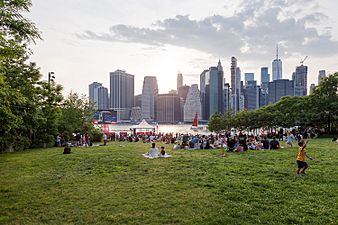
The World Science Festival on the Harbor View Lawn of Pier 1.
-
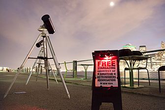
Free stargazing on Pier 1.
-
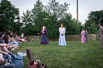
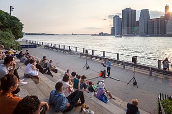
A play performed by New York Classical Theatre on Harbor View Lawn.


Pier 2: Active Fun

Pier 2 used to be a warehouse dock. It opened in May 2014 and is about 5-acre (2.0 ha) big. This pier is for active sports and games. It has courts for basketball, handball, bocce, and shuffleboard. There's also artificial grass, swings, and picnic tables. You can find restrooms, lockers, and bike racks here. Part of the pier is covered by an old warehouse roof. The Brooklyn Bridge Park Boathouse offers free summer kayaking here. There is also a roller rink on Pier 2.
A temporary public swimming pool was at Pier 2 every summer from 2012 to 2018. It was very popular. The temporary pool was removed in 2018. A new permanent pool is being built in nearby Squibb Park.
Pier 3 and Greenway Terrace
The Greenway Terrace opened in November 2013, next to Pier 3. It has large lawns, a granite area, and a hill that blocks noise. The granite blocks used here came from old bridges that were being rebuilt. This helps make the park more sustainable. The hill on Pier 3 is 20-foot-tall (6.1 m). It was made with materials from a subway tunneling project. This hill helps block noise from the Brooklyn Queens Expressway.
An art display called Dahn Vo: We the People was on Pier 3 in 2014. It was a copper copy of the Statue of Liberty, made in 250 pieces. Visitors could see a replica of the statue's arm.
Construction on Pier 3 itself started in 2016. This pier is 5 acres (2.0 ha) and has the park's only lawn. It also features a maze of mirrors, sound art, and climbable objects. It opened in July 2018. The playground on Pier 3 uses old bollards (posts) from the pier's industrial past.
Pier 4: Nature's Retreat
Pier 4 was finished in May 2014. It used to be an old railroad bridge that had fallen apart. Now, it's a wildlife preserve. It has plants native to the area. The beach has seven tidal pools, and some are open to visitors. Pier 4 also has places to launch boats.
A nature preserve called Bird Island is near Pier 4. It has shrubs, grasses, and trees from salty areas. It also has three tide pools. An Osprey platform was put up to attract large fishing birds. Native birds started using the beach once it opened.
Pier 5: Sports and Picnics


Pier 5 officially opened on December 13, 2012. It has three sports fields, two playgrounds, and a picnic area. It covers 5 acres (2.0 ha) and cost $26 million to build. The artificial turf fields can be used for soccer, lacrosse, Frisbee, cricket, and rugby. St. Francis College even plays its NCAA Division I soccer games here. The inland part of Pier 5 has 57 picnic tables, 24 grills, and a child-size telescope. The Pier 5 uplands opened in June 2017.
Pier 5 also has a marina that opened in May 2016. A new system was added in 2019 to make the water calmer. The marina has a floating dock. It offers free and low-cost kayaking, fishing, and sailing programs. A boathouse near the marina was finished in 2018.
Pier 6: Play and Relaxation
Pier 6 opened in mid-2010. It is at the end of Furman Street and Atlantic Avenue. Pier 6 has many different things to do. It has sand volleyball courts, food stands, a dog run, and lots of plants. The pier has four themed playgrounds: Swing Valley, Slide Mountain, Sandbox Village, and Water Lab. These playgrounds cover about 1.6 acres (0.65 ha). Pier 6 has mostly native plants, including a marsh garden and a large lawn.
The landscaped area of Pier 6 opened in late 2015. It has big lawns for events and shaded areas for visitors. Some historic boats have been docked near Pier 6 temporarily. The park is looking for a boat to display there permanently.
At the edge of Pier 6, there are three buildings. The Landing and Quay Tower, which are apartment and condo buildings, both opened in 2018. One Brooklyn Bridge Park, an old warehouse turned into apartments, was finished in 2007.
Most people like Pier 6. However, some have worried about the entrance being too close to the BQE ramps. There were also some lawsuits to stop the homes from being built at Pier 6. A legal agreement in 2015 allowed the buildings to be built, but with height limits.
Main Street: Under the Bridge


Main Street is the easternmost part of the park, under the Manhattan Bridge. It covers about 4.8 acres (1.9 ha). It opened in December 2002. Main Street has a nautical-themed playground, a dog run, and large lawns. You can get great views of the Manhattan skyline from here.
The Main Street area was updated in 2015. It got a bigger lawn, a better dog run, and easier paths for walking and biking. A new entrance plaza was added. A rock climbing wall was also built. In April 2016, a company called the Cliffs opened DUMBO Boulders here. It was the largest bouldering (rock climbing without ropes) place in North America when it opened.
Empire–Fulton Ferry: History and Fun


The Empire–Fulton Ferry section of the park is 4.5 acres (1.8 ha) of waterfront land. It is next to Main Street and connects to Pier 1. This area used to be a state park. It became part of Brooklyn Bridge Park in 2010. It has a lawn with picnic areas and a walkway facing the East River. Two old buildings from the Civil War era, the Tobacco Warehouse and Empire Stores, are here. Both are listed on the National Register of Historic Places.
Tobacco Warehouse
The Tobacco Warehouse used to be part of the state park. In 2010, a theater group called St. Ann's Warehouse was chosen to use it. There were some legal issues about this plan. In 2012, the city agreed to give the warehouse to St. Ann's. In return, St. Ann's would help create more parkland under the Brooklyn Bridge.
A design for the theater was shown in 2013. The Tobacco Warehouse had no roof and was shaped like a trapezoid. The design kept the old brick walls. It created an 18,000-square-foot (1,700 m2) indoor performance space. It also had a 7,600-square-foot (710 m2) outdoor landscaped area that is open to the public. The warehouse opened in 2015.
Empire Stores
Empire Stores is made up of seven buildings. They have a total of 330,000 square feet (31,000 m2) of space. In 2013, a developer was chosen to turn these old warehouses into shops and offices. The plan included restaurants, event areas, and a public walkway. Many of the original features, like stone walls and old machinery, were kept. The first store, West Elm, opened in August 2016. The Center for Brooklyn History also opened an exhibition space here in 2017. Empire Stores quickly became a popular spot for photos because of its waterfront location and views of the Brooklyn Bridge.
Western Area and Jane's Carousel
The western part of the park reopened in 2011. It has new plants, better lighting, and the restored Jane's Carousel. David and Jane Walentas gave the carousel as a gift to the park. It is inside a special glass and steel building designed by French architect Jean Nouvel. The carousel opened on September 15, 2011. A non-profit group called Friends of Jane's Carousel takes care of it.
In 2016, a large sign with the word "DUMBO" was placed in the John Street area. This sign, called the DUMBO Reflector, was created by local artist David Crumley. It allows people to interact with its displays using social media.
The River Café is also in the western part of the Empire–Fulton Ferry section. It is near the Brooklyn Bridge and Pier 1.
One of the last parts of the park to be built is a plaza under the Brooklyn Bridge. This area used to have a warehouse that was torn down in 2008. People are still discussing what to do with this space.
Getting to Brooklyn Bridge Park
You can reach the southern parts of the park by taking the B61 and B63 buses. The B25 bus serves the northern sections. The closest New York City Subway station is Clark Street on the IRT Broadway–Seventh Avenue Line (2 and 3 train). The subway tunnel runs under Pier 2.
The park also has two canals that show where the Cranberry Street Tunnel is. This tunnel is used by the A and C train subway line. Since 2017, NYC Ferry's South Brooklyn route serves Piers 1 and 6. The NYC Ferry's East River route also stops at Pier 1.
Images for kids
-
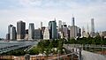
Manhattan skyline viewed from Brooklyn Bridge Park.
-
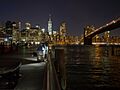
Night view of one of the piers.
-

Park and promenade viewed from Manhattan.
-
Statue of Liberty viewed from the park.


