
Brooklyn Heights Promenade facts for kids
The Brooklyn Heights Promenade, also known as the Esplanade, is a long walkway in Brooklyn Heights, Brooklyn, New York City. It stretches about 1,826 feet (557 meters) and offers amazing views of the Lower Manhattan skyline and the New York Harbor. This special walkway was created as a bonus feature when the Brooklyn-Queens Expressway (BQE) was being planned during World War II.
Even though it's built over a highway, the Promenade is maintained by NYC Parks. It runs between the famous Brooklyn Bridge and the ramp north of Atlantic Avenue. The Promenade is actually four levels high: the top is the walkway, then two levels for the highway (eastbound and westbound I-278), and finally Furman Street at the bottom.
Contents
How the Promenade Was Planned
The idea for a highway connecting Brooklyn and Queens came up even before World War II. In 1936, people started talking about linking the Gowanus Parkway in Brooklyn to the Triborough Bridge in Queens. An engineer even mapped a route along the East River waterfront in 1939.
Early Highway Ideas
Robert Moses, a powerful city planner, had a different idea. In 1941, he suggested building the highway right through the middle of the Brooklyn Heights neighborhood. This plan caused a lot of worry among the residents. The local newspaper, the Brooklyn Eagle, even had a front-page headline in September 1942 saying "Plan for Express Highway Is Shocking." It reported that Moses's route would cut through the neighborhood and might even require tearing down buildings.
Residents Fight for a Better Plan
This news made the people of Brooklyn Heights very upset. The Brooklyn Heights Association, a group representing the community, stepped in. Two key figures, Roy M.D. Richardson and Ferdinand W. Nitardy, worked hard to change the plan. They wanted the highway to run along the waterfront edge of the neighborhood instead. Engineers working on the highway also agreed that the waterfront route was better. It would cost less money than tearing down many buildings inland.
By March 1943, the waterfront route along Furman Street was chosen. The first idea was to build two three-lane roadways side-by-side on top of the Heights. Nitardy, who had a garden he wanted to save, asked if the highway could be built on two separate levels with a "cover" over them. Moses seemed to like this idea. A month later, it was decided that this "cover" wouldn't be private gardens but a public walkway. This is how the idea for the Promenade was born!
Building and Opening the Promenade

Work began in the fall of 1946, with old warehouses along Furman Street being torn down. The southern part of the Promenade opened to the public on October 7, 1950. The northern part followed on December 7, 1951. The highway itself wasn't ready for cars until 1954.
Early Success and Challenges
Many people in Brooklyn Heights were worried that the Promenade would bring too much noise and crime. But these fears quickly disappeared. The Promenade became a very popular spot for both locals and tourists.
Over the years, different people claimed they had the original idea for the Promenade. However, there isn't much proof for these claims. Even the engineers who designed it, like Ernest J. Clark, said it was a team effort. They explained that the design "evolved" as they figured out the best way to support the highway and make it look good.
Protecting the Views
In 1953, a new problem came up. The Port Authority, which owned warehouses on the waterfront side of Furman Street, wanted to build new structures up to 70 feet (21 meters) tall. This would block the amazing views from the new Promenade. People protested strongly. A big meeting was held, and officials like Robert Moses were there.
Even though Moses initially said the city couldn't just protect one view, the city did exactly that. On June 25, it limited buildings across from the Promenade to 50 feet (15 meters) tall. Later, in 1974, the city created a "Special Scenic District." This rule protects the views from the Promenade all the way to the middle of the East River. No new building can block this view. This rule is still in place today. The remaining old warehouses were torn down in the late 1950s, which opened up even more of the beautiful views.
The Promenade Today

With the creation of Brooklyn Bridge Park, the area in front of the Promenade now looks more like a natural landscape. The neighborhood around the Promenade continues to improve and become more popular. The Squibb Park Bridge was built in 2013 to connect the Promenade to the park. It had to be rebuilt between 2019 and 2020 because of some issues.
Future Repairs and Plans
In 2017, the New York City Department of Transportation started planning repairs for the Promenade. The structure has worn down over time. Experts estimated that if nothing was done, heavy vehicles might not be allowed on the expressway below by 2026. The entire Promenade section of the BQE might even need to close completely for rebuilding by 2036.
In 2018, two main repair options were suggested. One idea was to build a temporary 6-lane highway where the Promenade is now. This would allow them to fix the structure underneath. This option would close the Promenade for six years and cost a lot of money. Temporary viewing spots would be set up. After the project, part of the temporary highway would become a wider Promenade.
The other option was to repair the existing 3-lane highway below the Promenade one lane at a time. This would only close parts of the Promenade for two years, and some sections would stay open. However, rebuilding the BQE itself would take at least 8 years and also be very expensive. Because many people didn't like the first, cheaper option, the mayor said they would consider other ideas. One idea was to route the expressway slightly to the west, over the Brooklyn Bridge Park.
Images for kids
-
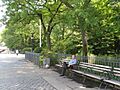
A man sitting on a bench on the Promenade
-
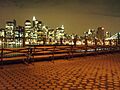
The view from the Promenade at night


