Aransas Bay facts for kids
Quick facts for kids Aransas Bay |
|
|---|---|
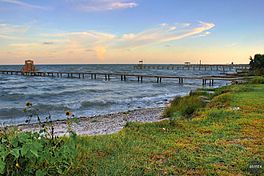
Piers near Fulton
|
|
 |
|
| Location | Texas Gulf Coast |
| Coordinates | 28°03′01″N 96°59′30″W / 28.05028°N 96.99167°W |
| Ocean/sea sources | Gulf of Mexico |
| Basin countries | United States |
| Surface area | 111,780 acres (45,240 ha) |
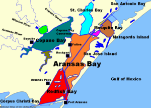
Aransas Bay is a big bay on the Texas Gulf Coast. It is about 30 miles (48 km) northeast of Corpus Christi. The bay is separated from the Gulf of Mexico by San José Island. Aransas Pass is the main way for boats to get from the bay to the Gulf.
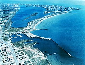
Cities like Aransas Pass and Port Aransas are at the south end of the bay. Rockport is on the western shore. Aransas Bay connects to other bays like Redfish Bay to the southwest and Copano Bay to the west. It also connects to Saint Charles Bay to the north and Mesquite Bay to the northeast. Aransas Bay is part of the Mission-Aransas National Estuarine Research Reserve.
Aransas Bay is one of seven major estuaries along the Texas Gulf Coast. An estuary is where fresh river water mixes with salty ocean water. People have lived around the bay for a very long time. This includes ancient Native American groups and towns built by European settlers in the 1800s. Today, cities like Rockport, Fulton, and Aransas Pass are here. The bay is important for local jobs because of its resources. These include shrimp, fish, oysters, and oil.
Contents
History of Aransas Bay
Humans first lived around Aransas Bay about 6,000 to 8,000 years ago. The bay gets its name from the Aransas Indians. These indigenous people were nomads, meaning they moved around a lot. Their old campsites, about 4,000 years old, have been found near the bay. The Aransas people left the area around 1200 to 1300 CE.
Later, by 1400, the Karankawa and Coahuiltecan peoples moved into the area. Sadly, many of them died in the 1800s from new diseases brought by European explorers. Alonso Álvarez de Pineda from Spain was likely the first European to sail into the bay around 1519. For over 100 years, Spain didn't pay much attention to the area. But when the French started a colony in Texas in the late 1600s, Spain became interested. Alonso De León was told to start a settlement, but no lasting Spanish colony was built on the bay.
During the time Mexico controlled the area, people were not allowed to settle on the bay. But in 1828, a special land grant allowed Irish and Mexican people to move there. In 1832, James Power founded Aransas City on the bay. Later, the nearby port of Lamar grew, and Aransas City was empty by 1846. But Lamar also faced problems. It was burned down during the American Civil War. The city of Aransas, on San Jose Island, was also destroyed in the war. During the war, the bay was important for moving goods. This was because barrier islands protected it from the rough Gulf seas.
After the war, new ports like Fulton and Rockport were built in the late 1860s. Rockport was first planned as a deep-water port. But after some issues, Aransas Pass was chosen for deepening in 1879. By 1912, a channel 100 feet (30 m) wide and 8.5 feet (2.6 m) deep was ready. However, strong hurricanes hit the port in 1916 and 1919. Because of this, the United States Army Corps of Engineers decided that Corpus Christi would be the main deepwater port for the lower Gulf Coast.
In the later 1900s, the area grew because of its natural beauty. In the 1960s, a fancy resort called Key Allegro was built between Rockport and Fulton. By 2000, over 24,000 people lived in Aransas County. This included the cities of Rockport, Fulton, and Aransas Pass.
Features of Aransas Bay
The Aransas Bay system is about 3 meters (10 feet) deep on average. It covers about 539 square kilometers (208 sq mi). The system includes the main bay and its connecting parts. These include Saint Charles Bay, Copano Bay, Mesquite Bay, and Redfish Bay. Redfish Bay is sometimes seen as part of Corpus Christi Bay.
Aransas Bay and its connecting bays form one of Texas's seven main estuaries. Rivers like the Mission River and the Aransas River flow into it. Smaller streams like Copano Creek also add water. About 28 cubic meters (990 cu ft) of water flows into the bay every second. Water also moves between the bay and the Gulf of Mexico at Cedar Bayou and Aransas Pass.
Because of the ocean water mixing in, the bay's saltiness is about 15 parts per thousand. This is less salty than the ocean, which is about 35 parts per thousand. Fresh water also comes from the Guadalupe River, which flows into San Antonio Bay. Fresh water makes up 60 to 70 percent of the bay system's water.
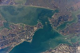
Texas State Highway 35 runs along the shore of Aransas Bay. It connects Corpus Christi to Houston. This highway includes the 1.5-mile (2.4 km) long Copano Bay causeway. This causeway connects two peninsulas where Copano and Aransas Bays meet. The first causeway was built in 1933. It was replaced in 1966 by the Lyndon Baines Johnson causeway. The old causeway became a popular fishing pier. In 1981, almost 10,000 cars crossed the bridge every day.
Aransas Bay Ecosystem
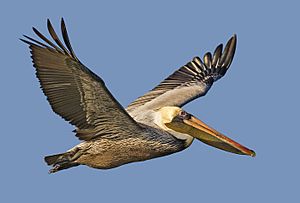
Many different animals live in and around Aransas Bay. Texas Parks and Wildlife says that many kinds of fish are caught here. These include catfish, black drum, red drum, eel, and southern flounder. Other fish like crevalle jack, ladyfish, and sea trout are also found. You can also find blacktip sharks, bull sharks, and sheepshead.
Shrimp, oysters, and crabs also live in the bay's waters. The sea grass beds are very important. They provide homes for fish and are great places for fish to lay their eggs. The grasses also help keep the bay clean by filtering out pollution.
Many birds come to the area around Aransas Bay. The Aransas National Wildlife Refuge is a special place for them. Some birds live here all year, like the brown pelican and roseate spoonbill. The endangered whooping crane has also been seen near the bay. In 1900, there were only 15 whooping cranes. Today, there are over 180 in the wild. The survival of whooping cranes and other birds depends on having enough blue crab. Thousands of crab traps have been removed to help protect the crab population.
Industry in Aransas Bay
Because of its location, shipping has always been a big business in Aransas Bay. After the Civil War, the meatpacking industry became very important for ports like Rockport and Fulton. Many slaughterhouses were built there. At first, cattle were killed mostly for their hides. This was because there was no way to keep the meat cold. So, most of the leftover cow parts were thrown into the bay.
This changed in 1871 when an ice machine was put in a packing plant. By this time, the meatpacking industry near Aransas Bay was at its peak. In 1880, 93% of the beef from Texas slaughterhouses was processed in Rockport-Fulton.
Along with fishing, oyster farming and especially shrimping became big industries in the early 1900s. Shipbuilding also grew after World War I. During World War II, the United States Navy took over several shipyards.
In 1936, oil was found in the bay. By 1946, 13 oil wells were working. In 1990, about 500,000 barrels of oil were produced. This was part of the 77 million barrels produced between 1936 and 1990.
Today, tourism is a very successful industry. Many hotels are built along the bay for people who want to fish, watch birds, or sight-see. A lot of hotels are in Rockport, where the bay's only beach, Rockport Beach, is located.
See also
 In Spanish: Bahía de Aransas para niños
 | Percy Lavon Julian |
 | Katherine Johnson |
 | George Washington Carver |
 | Annie Easley |


