Copano Bay facts for kids
Quick facts for kids Copano Bay |
|
|---|---|
 |
|
| Location | Texas Gulf Coast |
| Coordinates | 28°07′12″N 97°06′38″W / 28.12000°N 97.11056°W |
| River sources | Aransas River, Copano Creek, Mission River |
| Ocean/sea sources | Gulf of Mexico |
| Basin countries | United States |
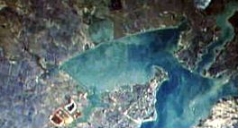
Copano Bay is a large bay in Texas, located west of Rockport, Texas. It is connected to Aransas Bay and gets its saltwater from the Gulf of Mexico. Freshwater flows into Copano Bay from rivers like the Aransas River, Mission River, and Copano Creek.
This bay is an estuary, which means it's a place where fresh river water mixes with salty ocean water. This mix creates a special home for many different plants and animals. You can find various birds here, including the rare whooping crane. Many fish, like the redfish, and shellfish, such as oysters, also live in the bay. Copano Bay is a protected area for young shrimp to grow.
People have lived and used Copano Bay for a long time, starting in the 1700s. Historic towns like El Copano and St. Mary's of Aransas were once important ports here. Today, towns like Bayside, Copano Village, and Holiday Beach are located around the bay. The area also has oil and natural gas, which helps the local economy. Recently, Hurricane Harvey passed over the bay, causing some damage.
Contents
History of Copano Bay
Copano Bay has a rich history, with people living there for thousands of years.
Early Inhabitants
About 4,000 years ago, the nomadic Aransas Indians lived along the shores of Copano Bay. They set up camps and hunted for food. Around 700 years ago, the Aransas people left the area.
Later, around the 1400s, the Copane Indians moved in. The bay is named after them. The Copane were part of the Karankawa people, who were hunter-gatherers living along the central Texas coast.
European Exploration and Settlements
In the early 1500s, Álvar Núñez Cabeza de Vaca was likely the first European to see the bay. His travel notes match the area's description. Later, in 1766, Diego Ortiz Parrilla explored the bay and named it Santo Domingo. However, its name was changed to Copano after the port of Copano opened in 1785.
The port of Copano was very important during the Texas Revolution and the American Civil War. It was once a busy settlement, but now it's completely abandoned. Another town, St. Mary's of Aransas, was founded nearby. It was a successful port until hidden reefs caused many shipwrecks, leading to its abandonment in 1875.
Modern Towns Around the Bay
Further southwest, near the Aransas River, the town of Black Point was started in the 1840s. It faced attacks and was abandoned for a while. However, it was re-established in the early 1900s and is now the city of Bayside. Developers tried to attract farmers to Bayside, but many people bought land just to sell it later, which made prices go up.
In the late 1800s, the cities of Fulton and Rockport grew on Aransas Bay. They also led to new communities along the eastern side of Copano Bay. These include Copano Village and Holiday Beach, which is near Goose Island State Park.
Features of Copano Bay
Copano Bay is about 12 miles long and 6 miles wide. It stretches from the southwest to the northeast. Much of the land around the bay is undeveloped, with some ranches on the western, southern, and northern sides.
Bay Extensions and Shoreline
The bay has a few main extensions. Mission Bay stretches north to the Mission River. Port Bay extends west and forms the southern edge of the Live Oak peninsula. The Live Oak peninsula is on the eastern side of Copano Bay. It has many beach homes and houses, starting from Salt Lake and going to where Copano Bay meets Aransas Bay.
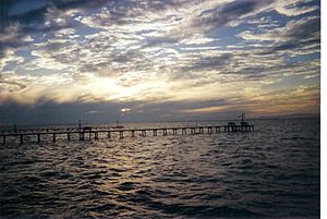
The Copano Bay Causeway and the Copano Bay Fishing Pier cross this opening. The pier was once the main way to get to the Lamar peninsula. Holiday Beach is on the northeastern shore of Copano Bay, on the Lamar Peninsula. North of Holiday Beach is where Copano Creek flows into the bay, marking its northernmost point.
From there, the shoreline turns southwest, passing the Copano Bay Oil and Gas Field. You can also see the ruins of the ghost town of Copano at Copano Point, which has white cliffs. At this point, the Copano Reef sticks out almost halfway across the bay. Further southwest, past Mission Bay, Bayside stretches along the coast to the Aransas River. The shoreline then turns southeast, passing through areas like Egery Flats and Swan Lake, and reaching Port Bay.
Bay Depth and Water Sources
Copano Bay is not very deep, with a maximum depth of about 10 feet (3 meters). Unlike the Laguna Madre to the south, Copano Bay is not extremely salty.
The Mission River and Aransas River are the main sources of fresh water for the bay. These are small rivers with deep banks that flow through areas with hardwood trees. The amount of water flowing into the bay increases when it rains a lot, especially in the autumn. These rivers flow freely because they have not been dammed. Where these rivers meet Copano Bay, there are large marsh areas that cover several square miles and form many salty lakes.
Ecosystem of Copano Bay
Copano Bay is a very important place for young shrimp to grow. This makes it a great spot for fish like redfish. You can also find many black drum, flounder, and trout in the bay.
Marine Life
Oysters grow in large groups, forming long reefs that stick out into the bay. These reefs are important because they provide homes for fish and food for many different birds. The most common type of snail (called a gastropod) in the bay is Eulimastoma harbisonae.
Bird Habitats
Many kinds of birds visit or live in Copano Bay. These include the black-bellied whistling-duck, black-necked stilt, brown pelican, gull-billed tern, reddish egret, roseate spoonbill, seaside sparrow, white-faced ibis, and the endangered whooping crane.
To protect these important bird habitats, the United States Department of the Interior gave $574,000 to Texas Parks and Wildlife in 2003. This money was used to buy over 900 acres (3.6 square kilometers) of land at Egery Flats and near the mouth of the Aransas River. This purchase helps prevent building on these areas, keeping them safe for birds.
Industry Around Copano Bay
Oil and natural gas are important industries around Copano Bay.
Oil and Gas Production
There are oil and natural gas wells both on land and in the bay itself. Three main oil and natural gas fields are located here:
- The Copano Bay Oil and Gas Field, west of Holiday Beach.
- The South Copano Bay Oil Field, just off the coast from Bayside.
- The West Fulton Beach Gas and Oil Field, west of the Live Oak peninsula.
In 1997, a pipeline owned by Koch Industries broke in a marsh near the Aransas River, about two miles (3 kilometers) west of Copano Bay. About 1,000 gallons of oil spilled over a 10-acre (40,000 square meter) area. Luckily, the oil did not reach Copano Bay, which prevented a bigger environmental problem.
Shrimping Restrictions
Because Copano Bay is a special "nursery bay" for young shrimp, shrimping (catching shrimp) is not allowed there. This rule helps protect the young shrimp so they can grow and keep the bay's ecosystem healthy.
See also
 In Spanish: Bahía de Copano para niños
 | Jackie Robinson |
 | Jack Johnson |
 | Althea Gibson |
 | Arthur Ashe |
 | Muhammad Ali |


