Port Aransas, Texas facts for kids
Quick facts for kids
Port Aransas, Texas
|
|
|---|---|
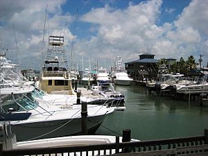
Boat dock at Port Aransas.
|
|
| Nickname(s):
Port A
|
|
| Motto(s):
Always in Season
|
|
| Country | United States |
| State | Texas |
| County | Nueces |
| Area | |
| • Total | 14.07 sq mi (36.44 km2) |
| • Land | 8.94 sq mi (23.16 km2) |
| • Water | 5.13 sq mi (13.28 km2) |
| Elevation | 7 ft (2 m) |
| Population
(2020)
|
|
| • Total | 2,904 |
| • Density | 476.97/sq mi (184.16/km2) |
| Time zone | UTC-6 (Central (CST)) |
| • Summer (DST) | UTC-5 (CDT) |
| ZIP code |
78373
|
| Area code(s) | 361 |
| FIPS code | 48-58808 |
| GNIS feature ID | 1344363 |
| Website | http://www.cityofportaransas.org/ |
Port Aransas is a city in Nueces County, Texas, United States. It is about 180 miles southeast of San Antonio. In 2020, about 2,904 people lived there.
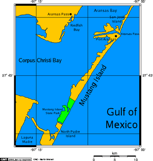
Port Aransas is the only town on Mustang Island. This island is north of Padre Island. It is one of the longest barrier islands along the Texas coast. The city is surrounded by waters like Corpus Christi Bay, the Gulf of Mexico, and important ship channels.
Contents
- A Look Back in Time: History of Port Aransas
- Early Days and Explorers
- Pirates of Port Aransas
- First European Settlers
- Life Saving Station and the Lighthouse
- Port Aransas During the Civil War
- The Tarpon Inn: A Historic Hotel
- Ropesville and the Changing Name
- The 1916 Hurricane
- Getting Around: Transportation to Port Aransas
- The University of Texas Marine Science Institute
- Port Aransas During World War II
- The Farley Boat: A Special Fishing Boat
- Hurricane Harvey
- Port Aransas Today
- Geography and Climate
- People of Port Aransas: Demographics
- Economy: How Port Aransas Makes Money
- Education: Schools in Port Aransas
- Notable People from Port Aransas
- See also
A Look Back in Time: History of Port Aransas
Early Days and Explorers
Long ago, the Karankawa Indians lived a nomadic life in this area. In 1519, Spanish explorers led by Alonso Álvarez de Pineda explored the coast. He mapped five passes along the Texas coastline, including what we now call Aransas Pass.
Later, in 1720, a French explorer named Pierre-Jean de Béranger rediscovered the Aransas Pass. In 1739, a Spanish governor named the pass "Aránzazu Pass." The name changed to Aransas in 1833.
Pirates of Port Aransas
In the early 1800s, Port Aransas was a popular spot for pirates. Famous pirate Capt. Jean Lafitte and his crew often visited the Texas coast. Mustang Island was one of his favorite places to set up camp.
Legend says that Capt. Lafitte even hid treasure on Mustang Island. People believe a Spanish silver dagger with a silver spike through its handle marks the spot.
First European Settlers
The first known permanent settler in Port Aransas was Capt. Robert Ainsworth Mercer from England. He started a sheep and cattle ranch called El Mar Rancho around 1853. When he arrived, wild mustangs roamed the island.
By 1854, a channel was planned from Corpus Christi to the Aransas Pass. This helped ships reach the Port of Corpus Christi. Steamship service also began between New Orleans and Mustang Island. This meant ships needed local pilots to guide them safely. So, buildings like docks, a lighthouse, and a general store were built.
Life Saving Station and the Lighthouse
In 1850, the United States Life-Saving Service built a station in Port Aransas. Its job was to help and rescue sailors from shipwrecks. Full-time crews worked there, much like a volunteer fire department.
The station was built on the same spot where the United States Coast Guard station is today. It had a dock and boats for rescues. John G. Mercer was the first keeper of this station.
The Aransas Pass Lighthouse was built starting in 1855. It guided ships through the pass at night. The lighthouse was very important for safe travel. It was turned off in 1952 because the channel shifted. A new light was then set up at the Port Aransas Coast Guard Station.
Port Aransas During the Civil War
During the American Civil War, the lighthouse was very important. Its light controlled who could pass at night. The lens was even hidden in the marsh to keep it from enemy forces.
The area supplied the Confederate Army with food and cotton. The Union Navy tried to stop these shipments. In 1862, Union Marines burned most of the town of Aransas on San Jose Island. The lighthouse was fought over by both sides during the war.
In December 1862, Confederate troops damaged the lighthouse tower with gunpowder. Later, in May 1863, Confederate soldiers attacked the Union troops protecting the lighthouse. Control of the island changed hands several times. In November, federal troops finally regained control.
The Tarpon Inn: A Historic Hotel
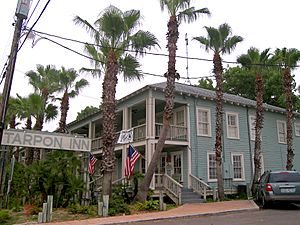
The Tarpon Inn was built in 1886 using wood from old Civil War buildings. It first housed workers building a jetty. In 1886, it became a hotel.
A big hurricane in 1919 damaged the inn. It was rebuilt in 1923 to look like the old barracks. The new building was very strong, with concrete pilings. Because of its strength, the Tarpon Inn has helped many people during storms. It has also served as a base for groups like the Red Cross.
Inside the Tarpon Inn, two walls are covered with tarpon scales. Each scale has the name and hometown of the person who caught the fish. It also shows the fish's size and the date it was caught. Many famous people have stayed here, including President Franklin D. Roosevelt in 1937. The Tarpon Inn was listed as a historic place in 1979.
Ropesville and the Changing Name
In 1887, Elihu Harrison Ropes wanted to build a deep-water port in Corpus Christi. He bought Mustang Island and tried to dig a channel through it. This project did not work out.
In 1888, the town's first official post office opened. It was named Ropesville. But this name did not last long. In 1896, the town's name changed to Tarpon because of the many game fish in the waters. The population was about 250 people then.
Later, the United States Army Corps of Engineers took over the project to deepen the channel. They built new jetties to improve the pass for ships.
The 1916 Hurricane
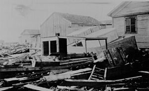
The 1916 Texas Hurricane caused a lot of damage in Port Aransas. Most buildings were destroyed. The island was flooded, and there were many rattlesnakes. But the people of Port Aransas did not give up. They rebuilt the Tarpon Inn and replaced the docks and warehouses. After the city was rebuilt, it became a popular place for fishing, tourism, and vacations.
Getting Around: Transportation to Port Aransas
In 1925, about 250 people lived on the island. By 1931, there were 300. A toll road opened in 1931, connecting Aransas Pass to the Port Aransas ferry landing. Before this, cars were loaded onto flatbed trains.
Today, the Port Aransas Ferry System offers free transportation 24 hours a day. It connects Mustang Island and Port Aransas to the mainland. The number of ferries running depends on how many people need to cross. Some ferries carry 20 vehicles, and newer ones carry 28. During busy times, you might have to wait a bit. The Texas Department of Transportation manages the ferry system.
The University of Texas Marine Science Institute
In 1935, Dr. E. J. Lund, a zoologist from the University of Texas, came to Port Aransas. He built a small shack to study marine life. He saw how valuable the local environment was. He also saw the need to teach people about the Gulf of Mexico's natural resources.
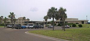
In 1941, The University of Texas Marine Science Institute was created. Dr. Lund was its first director. They studied marine fish and other topics. After World War II, the institute grew. Dr. Lund donated land, and more buildings were added. An old Army Corps of Engineers building from 1890 is still used as a dormitory today.
In 1946, the first permanent marine laboratory was built. More labs, dorms, and a boat basin were added in the 1970s.
Port Aransas During World War II
During World War II, the United States Army built an artillery gun turret on a high dune in Port Aransas. This was to protect the pass from German U-boats. The island had strict blackouts at night. No fires were allowed on the beach, and house windows had to be covered so no light could be seen.
The Farley Boat: A Special Fishing Boat
In the early 1900s, tarpon fishing became very popular in Port Aransas. But the waters around Port Aransas could be rough. The boats at that time were not good for these choppy waters. Storms often destroyed fishing boats.
To help anglers, the Farley family started building special boats called Farley boats. In 1915, Charles Frederick ("Fred") Farley and his son started their boat-building business. Farley boats had low sides and a high bow. This design helped them handle the rough waves. They also had low cabins, making it easy to fish in any direction.
In 1937, President Franklin D. Roosevelt visited Port Aransas to fish for tarpon. He hired Barney Farley, a famous fishing guide and Fred Farley's brother. The president brought his own boat, but Barney convinced him to try a Farley boat. The president caught many tarpon on the Farley boat! He even came back later that year to fish with Barney again.
Today, you can see Farley boat planters all over Port Aransas. They celebrate the history of these special boats.
Hurricane Harvey
In August 2017, Hurricane Harvey hit Port Aransas very hard. It caused major damage with strong winds.
Port Aransas Today
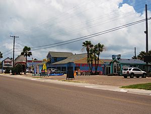
Today, Port Aransas is a popular place for fishing, beaches, and vacations. In summer, the population can grow to 60,000 people or more. It is also a popular spot for college spring break.
Every April, Port Aransas hosts Sand Fest. Thousands of people come to watch artists build amazing sand castles. The event also has food, shopping, and live music. All the money raised helps the community and local schools.
Geography and Climate
Port Aransas covers about 12.1 square miles (31.3 square kilometers). About 3.3 square miles (8.5 square kilometers) of this area is water. The city is located at 27°49′39″N 97°4′20″W.
Weather in Port Aransas
Port Aransas has a humid subtropical climate. This means it has warm temperatures, similar to other places along the Gulf Coast. The area gets about 35.55 inches (903 mm) of rain each year. Winds usually come from the southeast, off the Gulf of Mexico.
| Climate data for Port Aransas, Texas, 1991–2020 normals, extremes 1986–present | |||||||||||||
|---|---|---|---|---|---|---|---|---|---|---|---|---|---|
| Month | Jan | Feb | Mar | Apr | May | Jun | Jul | Aug | Sep | Oct | Nov | Dec | Year |
| Record high °F (°C) | 81 (27) |
87 (31) |
89 (32) |
94 (34) |
99 (37) |
98 (37) |
94 (34) |
99 (37) |
101 (38) |
95 (35) |
94 (34) |
82 (28) |
101 (38) |
| Mean maximum °F (°C) | 74.2 (23.4) |
75.9 (24.4) |
80.2 (26.8) |
85.3 (29.6) |
88.8 (31.6) |
91.7 (33.2) |
91.9 (33.3) |
93.7 (34.3) |
92.9 (33.8) |
88.7 (31.5) |
82.8 (28.2) |
77.3 (25.2) |
95.0 (35.0) |
| Mean daily maximum °F (°C) | 62.3 (16.8) |
64.9 (18.3) |
70.1 (21.2) |
75.8 (24.3) |
81.4 (27.4) |
86.8 (30.4) |
88.0 (31.1) |
88.7 (31.5) |
86.5 (30.3) |
81.2 (27.3) |
71.8 (22.1) |
65.3 (18.5) |
76.9 (24.9) |
| Daily mean °F (°C) | 56.4 (13.6) |
59.3 (15.2) |
65.1 (18.4) |
71.2 (21.8) |
77.3 (25.2) |
82.5 (28.1) |
83.8 (28.8) |
84.3 (29.1) |
81.6 (27.6) |
76.0 (24.4) |
66.3 (19.1) |
59.2 (15.1) |
71.9 (22.2) |
| Mean daily minimum °F (°C) | 50.4 (10.2) |
53.7 (12.1) |
60.1 (15.6) |
66.6 (19.2) |
73.2 (22.9) |
78.1 (25.6) |
79.6 (26.4) |
79.9 (26.6) |
76.8 (24.9) |
70.7 (21.5) |
60.9 (16.1) |
53.0 (11.7) |
66.9 (19.4) |
| Mean minimum °F (°C) | 36.8 (2.7) |
40.4 (4.7) |
44.9 (7.2) |
54.0 (12.2) |
64.1 (17.8) |
71.3 (21.8) |
74.6 (23.7) |
75.3 (24.1) |
67.7 (19.8) |
56.0 (13.3) |
44.5 (6.9) |
37.9 (3.3) |
33.7 (0.9) |
| Record low °F (°C) | 24 (−4) |
26 (−3) |
33 (1) |
42 (6) |
53 (12) |
65 (18) |
68 (20) |
70 (21) |
57 (14) |
42 (6) |
33 (1) |
12 (−11) |
12 (−11) |
| Average precipitation inches (mm) | 2.11 (54) |
1.92 (49) |
2.42 (61) |
2.00 (51) |
3.99 (101) |
3.72 (94) |
2.57 (65) |
1.80 (46) |
6.51 (165) |
3.92 (100) |
2.88 (73) |
1.71 (43) |
35.55 (902) |
| Average precipitation days (≥ 0.01 in) | 8.9 | 8.6 | 7.0 | 5.3 | 5.0 | 5.3 | 4.4 | 4.8 | 9.7 | 6.9 | 7.1 | 8.3 | 81.3 |
| Source 1: NOAA | |||||||||||||
| Source 2: National Weather Service | |||||||||||||
People of Port Aransas: Demographics
| Historical population | |||
|---|---|---|---|
| Census | Pop. | %± | |
| 1940 | 495 | — | |
| 1950 | 551 | 11.3% | |
| 1960 | 824 | 49.5% | |
| 1970 | 1,218 | 47.8% | |
| 1980 | 1,968 | 61.6% | |
| 1990 | 2,233 | 13.5% | |
| 2000 | 3,370 | 50.9% | |
| 2010 | 3,480 | 3.3% | |
| 2020 | 2,904 | −16.6% | |
| U.S. Decennial Census 2020 | |||
Who Lives in Port Aransas? (2020 Census)
In 2020, there were 2,904 people living in Port Aransas. There were 1,982 households and 1,314 families.
| Race | Number | Percentage |
|---|---|---|
| White (Non-Hispanic) | 2,498 | 86.02% |
| Black or African American (Non-Hispanic) | 4 | 0.14% |
| Native American or Alaska Native (Non-Hispanic) | 12 | 0.41% |
| Asian (Non-Hispanic) | 38 | 1.31% |
| Pacific Islander (Non-Hispanic) | 2 | 0.07% |
| Some other race (Non-Hispanic) | 22 | 0.76% |
| Mixed/multiracial (Non-Hispanic) | 114 | 3.93% |
| Hispanic or Latino | 214 | 7.37% |
| Total | 2,904 |
Economy: How Port Aransas Makes Money
Around 1900, Port Aransas was known for exporting sea turtles. Fishing has always been a big part of the economy, especially sport fishing for spotted seatrout and redfish. Over 600 types of saltwater fish live in the waters near Port Aransas. Fishing is still important, but there are sometimes disagreements between different fishing groups.
Today, tourism is the biggest part of the economy. Thousands of visitors come to the beach in Port Aransas every weekend from Memorial Day to Labor Day.
Port Aransas is also focusing more on ecotourism. The city and state have created places for bird-viewing. Kayak paddling trails also help ecotourism. Port Aransas is building a natural preservation area with hiking trails and other nature activities.
Education: Schools in Port Aransas
Public schools in Port Aransas are run by the Port Aransas Independent School District. The schools that serve the city are H.G. Olsen Elementary School, Brundrett Middle School, and Port Aransas High School.
Notable People from Port Aransas
- Dianna Hutts Aston, a children's author.
- Aline B. Carter, a poet and humanitarian.
- Steven A. Hickham Jr., a racing driver.
- Clinton Manges, an oil tycoon.
- Tom Pauken, a Texas lawyer and politician.
- Ryan Rose, a politician in Arkansas.
|
See also
 In Spanish: Port Aransas (Texas) para niños
 | Jewel Prestage |
 | Ella Baker |
 | Fannie Lou Hamer |


