
Corpus Christi Bay facts for kids
Quick facts for kids Corpus Christi Bay |
|
|---|---|

Corpus Christi Bay (right), Nueces Bay (top), and Oso Bay (bottom)
|
|

Corpus Christi Bay
Location in Texas
|
|
| Location | South Texas Gulf Coast |
| Coordinates | 27°46′20″N 97°15′10″W / 27.77222°N 97.25278°W |
| River sources | Nueces River, Oso Creek |
| Ocean/sea sources | Gulf of Mexico |
| Basin countries | United States |
| Surface area | 106,990 acres (43,300 ha) |
| Settlements | Corpus Christi, Portland, Ingleside, Ingleside on the Bay |
Corpus Christi Bay is a beautiful bay located on the Texas coast. It's found in San Patricio and Nueces counties, right next to the big city of Corpus Christi. A long strip of land called Mustang Island separates the bay from the Gulf of Mexico.
Freshwater flows into the bay from the Nueces River and Oso Creek. These rivers feed into two smaller parts of the bay: Nueces Bay to the west and Oso Bay to the south. Corpus Christi Bay is about 136 miles (219 km) south of San Antonio and 179 miles (288 km) southwest of Houston.
People have lived along the shores of Corpus Christi Bay for thousands of years. The bay helped the city of Corpus Christi grow, along with smaller towns like Ingleside and Portland. It's one of seven main estuaries (where rivers meet the sea) along the Texas Gulf Coast. Many different kinds of plants and animals live here, making it a popular spot for tourists. The bay also has lots of oil and natural gas, which has brought many industries to the area. Its location on the Texas coast is also important for military bases.
Contents
History of Corpus Christi Bay
The area around Corpus Christi Bay was likely home to the Karankawa Indians before Europeans arrived. Scientists have found old burial sites near Oso Bay that date back to between 500 BC and 500 AD.
Europeans probably first saw the bay on June 23, 1519, which was a special day called Corpus Christi Day. A Spanish explorer named Alonso Álvarez de Pineda sailed into its waters. Later, in 1746, Joaquín de Orobio y Basterra explored the bay. He tried to name it after St. Michael the Archangel, but the name "Corpus Christi Bay" stuck instead.
One of the first people to buy land on the bay was Blas María de la Garza Falcón in 1746. A small settlement called Villa de Vedoya was started near the Nueces River, but it didn't last long.
Early Settlements and Growth
The first trading post on Corpus Christi Bay was set up by Henry Kinney in 1838. This area later became the city of Corpus Christi. By the 1870s, it had a deepwater port, which means big ships could come in. In 1928, a famous sculptor named Gutzon Borglum (who carved Mount Rushmore) designed a large statue of Jesus Christ for the bayfront. However, the city decided not to build it. Corpus Christi grew into a major city, with a population of 277,454 people in 2000.
Henry Kinney also founded Nuecestown in 1852, near where the Nueces River meets Nueces Bay. This town faced an attack in 1875 and slowly declined. Today, it's a ghost town within the Corpus Christi city limits.
The city of Ingleside was founded on the northern shore of the bay in 1854. It grew slowly and had 9,388 residents in 2000. Similarly, Portland, founded in 1891, didn't grow as fast as Corpus Christi. It had 14,827 residents in 2000.
Bay Transportation
In the 1930s, steamboats were a common way to travel between Corpus Christi and Ingleside. Native Americans used a path made of shallow oyster beds, which they called Reef Road. This path was only about 18 to 24 inches deep. People could walk or ride horses across it during low tide to get from Nueces Bay to Corpus Christi Bay. Settlers found this path in the 1860s and used it for buggies.
A wooden bridge connecting Portland and Corpus Christi was first built in 1915. However, storms kept destroying it, so it had to be rebuilt many times. A strong concrete bridge was finally built in the 1950s, and another lane was added in 1988. This mile-long structure is now known as the Nueces Bay Causeway.
Military Importance
Corpus Christi Bay has always been important for the military. During the Mexican–American War, General Zachary Taylor stationed his soldiers on Rincon Point. Later, during the American Civil War, Confederate soldiers stopped a Union attack at the same spot in 1862. The Port of Corpus Christi was used by the Confederates to bring in supplies. However, Union forces took control of the bay and port from 1863 to 1870.
In 1940, the Naval Air Station Corpus Christi was built on the bay. By 1944, it had become a very large base. A notable event happened in March 1960. Future Senator John McCain was practicing a flight from the base when his plane crashed into Corpus Christi Bay. He managed to escape the cockpit, swim to the surface, and was rescued by a helicopter without serious injuries.
Features of Corpus Christi Bay


Corpus Christi Bay is part of the Texas Coastal Plain in South Texas. The land around it is quite dry and is used for ranching and farming. The bay itself has a subtropical climate, meaning it's warm most of the year. Gutzon Borglum, the sculptor, once called it "the most beautiful bay on the Texas coast."
The bay is about 10 feet (3 meters) deep on average and covers about 192 square miles (497 km²). Its two main parts are Nueces Bay to the west and Oso Bay to the south. Together, these form one of the seven major estuaries along the Texas Gulf Coast. It's the fourth largest estuary in Texas. About 34 cubic meters (9,000 gallons) of water flow into the bay every second.
Water from the Gulf of Mexico enters the bay at Aransas Pass. Because of this mix of fresh and saltwater, the bay's saltiness is about 22 parts per thousand (ppt). This is less salty than the ocean, which is usually around 35 ppt.
Exploring the Shoreline
Starting from the Naval Air Station Corpus Christi on the bay's southeastern side, you can explore the shoreline. Moving northwest, you cross where Oso Bay meets Corpus Christi Bay. On the other side is Ward Island (which is actually a peninsula), home to Texas A&M University–Corpus Christi.
Further northwest, the shore curves, and you can see the skyline of Corpus Christi in the distance. The land dips inward to form Emerald Cove, where a seawall has been built to protect the land. You can also spot the Alta Vista Reef in the bay from here.
As you go north along the shore, the seawall continues into the main city. It stops at the Industrial Canal, a waterway dug south of Nueces Bay that connects to Port Aransas. Another seawall runs slightly out in the water, protecting the coast. This seawall ends near Corpus Christi Beach.
North of the canal, you'll find Corpus Christi Beach, which stretches to Rincon Point. Here, Corpus Christi Bay opens into Nueces Bay. To cross, you use the Nueces Bay Causeway, which leads to Indian Point near Portland. From there, Indian Reef extends offshore.
Past Portland, the shore curves southeast. You'll see the large La Quinta Island with industrial plants in Ingleside behind it. The La Quinta Channel, dug by the Army Corps of Engineers in the 1950s, runs between the island and the shore. Ingleside Cove is formed in this area. The shore then curves southwest, where Ingleside on the Bay is located. To the southeast, a series of islands separate Corpus Christi Bay from Redfish Bay.
Ecosystem of Corpus Christi Bay
The Environmental Protection Agency (EPA) has recognized the Corpus Christi Bay system as a very important estuary for the whole country. More than 234 types of fish live in the bay. Some common ones include the Gafftopsail catfish, Hardhead catfish, Atlantic croaker, Black drum, Red drum, Southern flounder, and Spotted seatrout.
In 2009, $1 million was used to help restore the marshland near the Nueces Bay Causeway. This project aimed to increase the number of birds and fish in the area. The Coastal Bend Bays and Estuaries Program and the U.S. Fish and Wildlife Service worked together to add soil and plant marsh. This created more places for young fish to grow and provided more food for water birds.
Over 490 types of birds have been seen in the area! These include the brown pelican, reddish egret, white-faced ibis, golden-fronted woodpecker, and the peregrine falcon. Bird populations are protected, and you can watch them at the Hans and Pat Suter Wildlife Refuge on Oso Bay.
Industry and Tourism

Corpus Christi Bay is a natural harbor, which means it's a great place for ships. The port of Corpus Christi is the 5th largest in the United States and the deepest on the Gulf of Mexico. A channel was dug through the bay to allow ships to reach the Gulf at Port Aransas.
The port handles many goods, including seafood, farm products, and especially petroleum. There are six oil refineries and 1,500 oil wells near the bay, along with a large amount of natural gas. In 1987 alone, oil and gas worth $277 million were produced in the area. Other products made near the bay include metals, stone, glass, and chemicals.
Tourism is also a big part of the bay's economy. People visit because of the warm climate, great fishing, and birdwatching. Popular attractions in Corpus Christi include Corpus Christi beach, the Texas State Aquarium, the USS Lexington Museum, the bayfront marina, and the Corpus Christi Museum of Science and History. The bay has also hosted big events like the U.S. Wind and Water Open and the Texas International Boat Show.
Images for kids
-
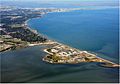
Corpus Christi Bay (right), Nueces Bay (top), and Oso Bay (bottom)
-
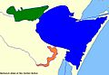
Corpus Christi Bay (blue), Oso Bay (orange), Nueces Bay (green)
-
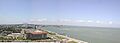
A spoils island shown from the shore of Corpus Christi Bay at Rincon Point
-
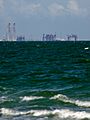
Industry toward Ingleside
See also
 In Spanish: Bahía de Corpus Christi para niños
