San Patricio County, Texas facts for kids
Quick facts for kids
San Patricio County
|
|
|---|---|

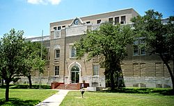
Built in 1927 (Henry T. Phelps), this is the eighth structure to serve as the San Patricio County Courthouse in Sinton.
|
|

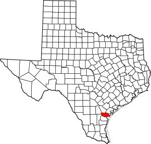
Location within the U.S. state of Texas
|
|
 Texas's location within the U.S. |
|
| Country | |
| State | |
| Founded | 1836 |
| Named for | Saint Patrick |
| Seat | Sinton |
| Largest city | Corpus Christi |
| Area | |
| • Total | 708 sq mi (1,830 km2) |
| • Land | 693 sq mi (1,790 km2) |
| • Water | 14 sq mi (40 km2) 2.0%% |
| Population
(2020)
|
|
| • Total | 68,755 |
| • Density | 97.11/sq mi (37.495/km2) |
| Time zone | UTC−6 (Central) |
| • Summer (DST) | UTC−5 (CDT) |
| Congressional district | 27th |
San Patricio County is a county located in the state of Texas in the United States. In 2020, about 68,755 people lived there. The main town and county seat is Sinton. San Patricio County is part of the larger Corpus Christi area.
Contents
History of San Patricio County
In 1828, a group of 200 Irish Catholic families came to this area. They were invited by the Mexican government to settle on a large piece of land. By 1836, around 500 people lived in this new settlement.
During the Texas Revolution, many people had to leave because of fighting. But by 1841, some permanent residents had returned. When Texas joined the United States in 1845, the area became more stable. This was helped by U.S. troops led by General Zachary Taylor.
In 1845, San Patricio County was officially formed. Its name, "San Patricio," is Spanish for Saint Patrick. Saint Patrick is a very important saint in Ireland, the home country of many of the first settlers. At first, Corpus Christi was chosen as the county seat.
The next year, the county was reorganized. The town of San Patricio became the new county seat for San Patricio County. In 1848, the county became smaller as new counties were created from its land.
By 1850, only about 200 people lived in the county. The main way people made a living was by raising cattle. In the mid-1860s, more settlers moved in because land was cheap. By 1870, the population grew to 602 people. There were 51 farms and ranches, covering about 52,000 acres (210 km²).
The county grew a lot in the early 1900s. Many farmers moved here from other parts of Texas and other states. The population reached 7,307 by 1910 and 11,386 by 1920. Cattle ranching was still important, but growing vegetables and cotton also became very popular. The amount of land used for cotton grew from about 15,000 acres (61 km²) in 1910 to 155,000 acres (627 km²) by 1930.
Geography of San Patricio County
San Patricio County covers a total area of 708 square miles (1,830 km²). Most of this is land, about 693 square miles (1,790 km²). The rest, about 14 square miles (36 km²), is covered by water.
The Gulf of Mexico is on the eastern side of the county.
Main Roads in San Patricio County
 Interstate 37
 U.S. Highway 77
 U.S. Highway 181
 State Highway 35
 State Highway 188
 State Highway 359
 State Highway 361
 Farm to Market Road 136
Neighboring Counties
- Bee County (north)
- Refugio County (north)
- Aransas County (northeast)
- Nueces County (south)
- Jim Wells County (southwest)
- Live Oak County (northwest)
Population of San Patricio County
| Historical population | |||
|---|---|---|---|
| Census | Pop. | %± | |
| 1850 | 200 | — | |
| 1860 | 620 | 210.0% | |
| 1870 | 602 | −2.9% | |
| 1880 | 1,010 | 67.8% | |
| 1890 | 1,312 | 29.9% | |
| 1900 | 2,372 | 80.8% | |
| 1910 | 7,307 | 208.1% | |
| 1920 | 11,386 | 55.8% | |
| 1930 | 23,836 | 109.3% | |
| 1940 | 28,871 | 21.1% | |
| 1950 | 35,842 | 24.1% | |
| 1960 | 45,021 | 25.6% | |
| 1970 | 47,288 | 5.0% | |
| 1980 | 58,013 | 22.7% | |
| 1990 | 58,749 | 1.3% | |
| 2000 | 67,138 | 14.3% | |
| 2010 | 64,804 | −3.5% | |
| 2020 | 68,755 | 6.1% | |
| U.S. Decennial Census 1850–2010 2010–2014 |
|||
In 2020, San Patricio County had 68,755 people living there. There were 23,422 households and 16,838 families.
Back in 2000, there were 67,138 people. The population density was about 97 people per square mile (37 people per km²). About 49.42% of the people were of Hispanic or Latino background.
In 2000, about 41.6% of households had children under 18. About 60.6% were married couples. The average household had 2.97 people, and the average family had 3.40 people.
The median age in the county was 32 years old. About 31.1% of the population was under 18. About 10.5% were 65 or older. For every 100 females, there were about 100.50 males.
Communities in San Patricio County
Cities (in multiple counties)
- Aransas Pass (also in Aransas and Nueces Counties)
- Corpus Christi (mostly in Nueces County, with small parts in Kleberg and Aransas Counties)
- Ingleside (small part in Nueces County)
- Portland (small part in Nueces County)
- San Patricio (small part in Nueces County)
Cities
Towns
Census-designated places
Former census-designated places
- Del Sol-Loma Linda
- Doyle
- Country Acres (now part of Aransas Pass)
- Edgewater-Paisano
- Falman-County Acres
Unincorporated community
- Sodville
Education in San Patricio County
Here are the school districts in San Patricio County:
- Aransas Pass Independent School District
- Gregory-Portland Independent School District
- Ingleside Independent School District
- Mathis Independent School District
- Odem-Edroy Independent School District
- Sinton Independent School District
- Skidmore-Tynan Independent School District
- Taft Independent School District
Del Mar College is the community college for everyone in San Patricio County.
See also
 In Spanish: Condado de San Patricio para niños
 | Stephanie Wilson |
 | Charles Bolden |
 | Ronald McNair |
 | Frederick D. Gregory |

