Refugio County, Texas facts for kids
Quick facts for kids
Refugio County
|
|
|---|---|

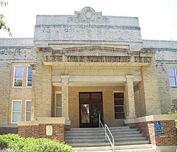
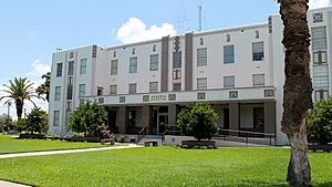
The Refugio County Courthouse in Refugio
|
|

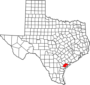
Location within the U.S. state of Texas
|
|
 Texas's location within the U.S. |
|
| Country | |
| State | |
| Founded | 1837 |
| Named for | Refugio |
| Seat | Refugio |
| Largest town | Refugio |
| Area | |
| • Total | 818 sq mi (2,120 km2) |
| • Land | 770 sq mi (2,000 km2) |
| • Water | 48 sq mi (120 km2) 5.8%% |
| Population
(2020)
|
|
| • Total | 6,741 |
| • Density | 8.241/sq mi (3.1818/km2) |
| Time zone | UTC−6 (Central) |
| • Summer (DST) | UTC−5 (CDT) |
| Congressional district | 27th |
Refugio County is a county located in the U.S. state of Texas. Its name is pronounced "rih-FURE-ee-oh". In 2020, about 6,741 people lived there. The main town and county seat is Refugio.
Refugio County started as a Mexican area in 1834. It officially became a county in Texas in 1837.
Contents
Exploring Refugio County's Geography
Refugio County covers a total area of 818 square miles. About 48 square miles of this area is covered by water. This means about 5.8% of the county is water.
Main Roads and Highways
Several important roads help people travel through Refugio County:
 U.S. Highway 77


 U.S. Highway 77 Alternate/U.S. Highway 183
 State Highway 35
 State Highway 239
 Farm to Market Road 136
 Farm to Market Road 774
 Farm to Market Road 2441
 Farm to Market Road 2678
Neighboring Counties
Refugio County shares borders with these other counties:
- Victoria County (to the north)
- Calhoun County (to the northeast)
- Aransas County (to the southeast)
- San Patricio County (to the south)
- Bee County (to the west)
- Goliad County (to the northwest)
Protected Natural Areas
A part of the Aransas National Wildlife Refuge is located in Refugio County. This refuge helps protect wildlife and their homes.
Refugio County's Population Over Time
| Historical population | |||
|---|---|---|---|
| Census | Pop. | %± | |
| 1850 | 288 | — | |
| 1860 | 1,600 | 455.6% | |
| 1870 | 2,324 | 45.3% | |
| 1880 | 1,585 | −31.8% | |
| 1890 | 1,239 | −21.8% | |
| 1900 | 1,641 | 32.4% | |
| 1910 | 2,814 | 71.5% | |
| 1920 | 4,050 | 43.9% | |
| 1930 | 7,691 | 89.9% | |
| 1940 | 10,383 | 35.0% | |
| 1950 | 10,113 | −2.6% | |
| 1960 | 10,975 | 8.5% | |
| 1970 | 9,494 | −13.5% | |
| 1980 | 9,289 | −2.2% | |
| 1990 | 7,976 | −14.1% | |
| 2000 | 7,828 | −1.9% | |
| 2010 | 7,383 | −5.7% | |
| 2020 | 6,741 | −8.7% | |
| U.S. Decennial Census 1850–2010 2010–2014 |
|||
Who Lives in Refugio County?
In 2020, there were 6,741 people living in Refugio County. These people lived in 2,566 households. About 1,730 of these households were families.
Back in 2000, the county had 7,828 people. The population density was about 10 people per square mile. The people living in the county came from many different backgrounds. About 48.6% of the population were of Hispanic or Latino origin.
Many households had children under 18 living with them. Most households were married couples. Some households had a female head with no husband. Others were individuals living alone. The average household had about 2.59 people.
The average age of people in the county in 2000 was 39 years old. About 26.1% of the population was under 18. About 16.6% of the population was 65 or older.
The average income for a household was around $29,986. For families, it was about $36,162. About 17.8% of all people in the county lived below the poverty line. This included 24.2% of children under 18.
Oil and Gas in Refugio County
Refugio County is known for its oil and gas. Gas was first found near Refugio town in 1920. Oil was discovered there in 1928. By the end of 1937, the Refugio oil and gas field had produced a lot of energy.
A big oil field called Greta was found in 1933. Another very large oil field, the Tom O'Connor oil field, was discovered in 1934. This field has produced hundreds of millions of barrels of oil. Other important oil and gas fields in the county include Anaqua, Bonnie View, and La Rosa.
The last major oil field found in Refugio County was the Lake Pasture oil field in 1953. It has also produced a lot of oil over the years.
Healthcare Services
Refugio County provides medical care to its residents. This includes a county hospital, several local health clinics, and a special wellness clinic.
The Refugio County Medical Center opened in 1940. It grew bigger in 1962 and 2009 to serve more people. Religious groups ran the hospital until the 1970s. Then, Refugio County took over its operations. A special hospital district was set up in 1977 to manage healthcare.
Communities in Refugio County
Refugio County has several towns and communities.
Cities
Towns
Census-Designated Place
Historic Ghost Towns
Some old towns in the county are now "ghost towns," meaning they are no longer populated:
Famous People from Refugio County
- Nicholas Fagan – An early settler and important person in the Texas Revolution.
- James Power – A leader who helped bring settlers to Refugio County.
- Thomas O'Connor – He also took part in the Texas Revolution. Later, he became one of the biggest land and cattle owners in Texas.
Education in Refugio County
Children in Refugio County attend schools in these districts:
- Austwell-Tivoli Independent School District
- Refugio Independent School District
- Woodsboro Independent School District
For higher education, most parts of the county are served by Victoria College.
See also
 In Spanish: Condado de Refugio para niños
 | Mary Eliza Mahoney |
 | Susie King Taylor |
 | Ida Gray |
 | Eliza Ann Grier |


