Calhoun County, Texas facts for kids
Quick facts for kids
Calhoun County
|
|
|---|---|

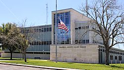
Calhoun County Courthouse
|
|

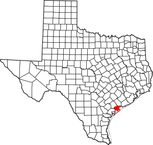
Location within the U.S. state of Texas
|
|
 Texas's location within the U.S. |
|
| Country | |
| State | |
| Founded | 1846 |
| Named for | John C. Calhoun |
| Seat | Port Lavaca |
| Largest city | Port Lavaca |
| Area | |
| • Total | 1,033 sq mi (2,680 km2) |
| • Land | 507 sq mi (1,310 km2) |
| • Water | 526 sq mi (1,360 km2) 51%% |
| Population
(2020)
|
|
| • Total | 20,106 |
| • Density | 39.7/sq mi (15.3/km2) |
| Time zone | UTC−6 (Central) |
| • Summer (DST) | UTC−5 (CDT) |
| Congressional district | 27th |
Calhoun County is a county located in the U.S. state of Texas. In 2020, about 20,106 people lived there. Its main town, or county seat, is Port Lavaca. The county is named after John Caldwell Calhoun, who was the seventh vice president of the United States. Calhoun County is part of a larger area that includes Victoria.
Contents
History of Calhoun County
Calhoun County has a long and interesting history. Many different groups of people have lived here over time.
Early Inhabitants and Explorers
- Long ago, Paleo-Indians and later Native American tribes like the Comanche, Tonkawa, and Karankawa lived in this area.
- In 1685, a French explorer named René-Robert Cavelier, Sieur de La Salle landed near Powderhorn Lake. France claimed the land for a short time.
- Spanish explorers, including Alonso De León, explored the future county in 1689.
- In 1825, Martín De León from Mexico started a ranch near the old French fort.
- The first Anglo settlement was Linnville, started in 1831 by John J. Linn, an Irish merchant.
- In 1840, Comanche warriors attacked and looted Linnville.
Settlement and County Formation
- From 1842 to 1847, Henri Castro helped Alsatian immigrants from France come to Texas. They used Port Lavaca as a stop before moving to settle Castroville.
- In 1845, many German immigrants arrived at Indianola on Matagorda Bay.
- Calhoun County was officially formed in 1846. It was created from parts of Victoria, Jackson, and Matagorda counties. It was named for John C. Calhoun. Lavaca was the first county seat.
- In 1852, Indianola became the county seat. Ships regularly traveled from Indianola to New York City.
- Poles began arriving in Indianola in 1854.
- The Half Moon Reef Lighthouse was built in Matagorda Bay in 1858.
Civil War and Natural Disasters
- By 1860, the county had 2,642 people, including 414 enslaved people.
- In 1861, Calhoun County voted to leave the Union and join the Confederacy. Fort Esperanza, on Matagorda Island, was built by Confederate forces using enslaved labor.
- Union ships attacked Port Lavaca in 1862.
- A hurricane caused great damage to Indianola in 1875.
- Another powerful hurricane destroyed Indianola in 1886.
Modern Development
- The Lutheran community of Olivia was founded by Swedes in 1892.
- Port O’Connor was established in 1909.
- Port Lavaca built a seawall in 1920 to protect against hurricanes.
- The Lavaca Bay causeway was built in 1931.
- Oil and natural gas were found near Port Lavaca in 1934-1935.
- Alcoa opened a factory at Point Comfort in 1947.
- Union Carbide opened a factory near Seadrift in 1952.
- In 1961, Hurricane Carla, a very strong storm, hit the area.
- Since 1983, Matagorda Island State Park has been managed for wildlife and recreation.
Geography
Calhoun County covers about 1,033 square miles. About 507 square miles is land, and 526 square miles (51%) is water. It is located next to the Gulf of Mexico.
Neighboring Counties
- Jackson County (north)
- Matagorda County (east)
- (Gulf of Mexico) (southeast)
- Aransas County (southwest)
- Refugio County (west)
- Victoria County (northwest)
Protected Areas
- Part of the Aransas National Wildlife Refuge is in Calhoun County.
Population Information
| Historical population | |||
|---|---|---|---|
| Census | Pop. | %± | |
| 1850 | 1,110 | — | |
| 1860 | 2,642 | 138.0% | |
| 1870 | 3,443 | 30.3% | |
| 1880 | 1,739 | −49.5% | |
| 1890 | 815 | −53.1% | |
| 1900 | 2,395 | 193.9% | |
| 1910 | 3,635 | 51.8% | |
| 1920 | 4,700 | 29.3% | |
| 1930 | 5,385 | 14.6% | |
| 1940 | 5,911 | 9.8% | |
| 1950 | 9,222 | 56.0% | |
| 1960 | 16,592 | 79.9% | |
| 1970 | 17,831 | 7.5% | |
| 1980 | 19,574 | 9.8% | |
| 1990 | 19,053 | −2.7% | |
| 2000 | 20,647 | 8.4% | |
| 2010 | 21,381 | 3.6% | |
| 2020 | 20,106 | −6.0% | |
| U.S. Decennial Census 1850–2010 2010–2020 |
|||
2020 Census Details
In 2020, there were 20,106 people living in Calhoun County. The population included people from many different backgrounds.
| Race / Ethnicity (NH = Non-Hispanic) | Pop 2000 | Pop 2010 | Pop 2020 | % 2000 | % 2010 | % 2020 |
|---|---|---|---|---|---|---|
| White alone (NH) | 10,774 | 9,794 | 8,374 | 52.18% | 45.81% | 41.65% |
| Black or African American alone (NH) | 521 | 519 | 361 | 2.52% | 2.43% | 1.80% |
| Native American or Alaska Native alone (NH) | 55 | 36 | 34 | 0.27% | 0.17% | 0.17% |
| Asian alone (NH) | 665 | 943 | 1,112 | 3.22% | 4.41% | 5.53% |
| Pacific Islander alone (NH) | 7 | 4 | 0 | 0.03% | 0.02% | 0.00% |
| Other race alone (NH) | 16 | 15 | 56 | 0.08% | 0.07% | 0.28% |
| Mixed race or Multiracial (NH) | 161 | 148 | 311 | 0.78% | 0.69% | 1.55% |
| Hispanic or Latino (any race) | 8,448 | 9,922 | 9,858 | 40.92% | 46.41% | 49.03% |
| Total | 20,647 | 21,381 | 20,106 | 100.00% | 100.00% | 100.00% |
Education
All schools in Calhoun County are part of the Calhoun County Independent School District. The county is also served by Victoria College. Our Lady of the Gulf Catholic School, which teaches students from pre-kindergarten to 8th grade, has been open since 1996.
Transportation
Main Roads
Airport
The Calhoun County Airport is a general aviation airport. It is located northwest of Port Lavaca.
Communities
Cities
- Point Comfort
- Port Lavaca (county seat)
- Seadrift
Census-designated places
Other Communities
- Long Mott
- Olivia
- Port Alto
- Schicke Point
Ghost Towns
- Indianola
- Kamey
- Sixmile
See also
 In Spanish: Condado de Calhoun (Texas) para niños
 | Selma Burke |
 | Pauline Powell Burns |
 | Frederick J. Brown |
 | Robert Blackburn |

