
Castroville, Texas facts for kids
Quick facts for kids
Castroville, Texas
|
||
|---|---|---|

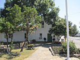
Castroville City Hall
|
||
|
||
| Nickname(s):
The Little Alsace of Texas
|
||

Location of Castroville, Texas
|
||
 |
||
| Country | United States | |
| State | Texas | |
| County | Medina | |
| Incorporated | January 16, 1850 | |
| Government | ||
| • Type | Council-Manager | |
| Area | ||
| • Total | 2.91 sq mi (7.55 km2) | |
| • Land | 2.88 sq mi (7.46 km2) | |
| • Water | 0.03 sq mi (0.09 km2) | |
| Elevation | 771 ft (235 m) | |
| Population
(2020)
|
||
| • Total | 2,954 | |
| • Density | 1,015.1/sq mi (391.3/km2) | |
| Time zone | UTC-6 (Central (CST)) | |
| • Summer (DST) | UTC-5 (CDT) | |
| ZIP codes |
78009, 78023
|
|
| Area code(s) | 830 | |
| FIPS code | 48-13312 | |
| GNIS feature ID | 2409411 | |

Castroville is a city in Medina County, Texas, United States. In 2020, its population was 2,954 people. This was a growth from 2,680 people counted in the 2010 census. Castroville is part of the larger San Antonio area.
The city was founded by people from Alsace, a region in Europe. These Alsatian-Texans came to Texas in the mid-1800s. Many of them spoke Alsatian, a special language that mixes German, Celtic, Yiddish, and French words. Even today, the people of Castroville work to keep their unique Alsatian culture and language alive. Before 1893, Castroville was the main town (county seat) of Medina County.
Contents
History of Castroville
How Castroville Was Founded
Castroville was started in 1844 by Henri Castro. He was an empresario for the Republic of Texas. This meant he was given land and permission to bring European families to settle it. He brought many families from Alsace and nearby Baden to his land along the Medina River. This spot was about 20 miles (32 km) west of San Antonio.
The first settlers arrived in Texas on January 9, 1843. They traveled by ship to Lavaca Bay. From there, they went overland to San Antonio. They stayed in empty buildings until the Texas Rangers could safely take them to their new land. The Rangers also protected them from hostile Native American groups. On September 2, 1844, the first colonists finally reached Castro's land on the Medina River.
Castroville as a Travel Stop
Starting in 1849, Castroville became an important stop. It was a place where travelers could get water along the San Antonio-El Paso Road. It also served as a stagecoach station for mail lines. These included the San Antonio-El Paso Mail Line and the San Antonio-San Diego Mail Line.
Keeping the Alsatian Language Alive
After a few difficult years, the town and its farms began to do very well. For many generations, the residents mostly kept to themselves. For the first 100 years of Castroville, visitors would often hear Alsatian spoken. This was more common than hearing English in homes, shops, and taverns.
Modern travelers from Alsace have noticed that the dialect spoken in Castroville is very similar to how it was spoken in the 1840s. The families who first settled here have worked hard to save their language. In Europe, the use of Alsatian has decreased, especially since World War II. This is due to political changes in France and Germany.
The Steinbach Haus
A special building called the Steinbach Haus is in Castroville. It was originally built in Alsace, France, between 1618 and 1648. The house was carefully taken apart in Alsace. Then, it was brought to Castroville and rebuilt in 1998. It opened to the public in 2002.
Sister Cities of Castroville
Castroville has two "twin towns" or sister cities. These are towns that share a special bond, often because of history or culture. Both of Castroville's sister cities are in Alsace, France:
Geography and Transportation
Where is Castroville Located?
Castroville is located about 26 miles (42 km) west of downtown San Antonio. The city covers a total area of about 2.5 square miles (6.5 square kilometers). Only a very small part of this area is covered by water.
Getting Around Castroville
U.S. Route 90 is a main road that goes through the middle of Castroville. If you go west on this road, you will reach Hondo in about 16 miles (26 km). If you go east, you will get to downtown San Antonio in about 25 miles (40 km).
The closest airport with flights is San Antonio International Airport. This airport is on the north side of San Antonio, about 30 miles (48 km) east of Castroville.
Population and People
How Many People Live Here?
| Historical population | |||
|---|---|---|---|
| Census | Pop. | %± | |
| 1850 | 366 | — | |
| 1860 | 458 | 25.1% | |
| 1870 | 515 | 12.4% | |
| 1880 | 731 | 41.9% | |
| 1890 | 679 | −7.1% | |
| 1950 | 985 | — | |
| 1960 | 1,508 | 53.1% | |
| 1970 | 1,893 | 25.5% | |
| 1980 | 1,821 | −3.8% | |
| 1990 | 2,159 | 18.6% | |
| 2000 | 2,664 | 23.4% | |
| 2010 | 2,680 | 0.6% | |
| 2020 | 2,954 | 10.2% | |
| U.S. Decennial Census | |||
The population of Castroville has grown steadily over the years. In 2020, there were 2,954 people living in the city. There were 1,113 households and 860 families.
Who Lives in Castroville? (2020 Census)
The 2020 United States census showed the different groups of people living in Castroville:
| Race | Number | Percentage |
|---|---|---|
| White (NH) | 1,620 | 54.84% |
| Black or African American (NH) | 21 | 0.71% |
| Native American or Alaska Native (NH) | 8 | 0.27% |
| Asian (NH) | 19 | 0.64% |
| Pacific Islander (NH) | 1 | 0.03% |
| Some other race (NH) | 10 | 0.34% |
| Mixed/multiracial (NH) | 47 | 1.59 |
| Hispanic or Latino | 1,228 | 41.57% |
| Total | 2,954 |
More About the Population (2010 Census)
In 2010, there were 3,053 people living in Castroville. The city had 1,025 housing units. Out of 941 households, about 37.4% had children under 18 living there. About 61.5% were married couples. Around 10.4% had a female head of household with no husband. About 23.5% were not families.
The average household size was 2.74 people. The average family size was 3.17 people. The population was spread out by age:
- 28.0% were under 18
- 6.9% were from 18 to 24
- 27.7% were from 25 to 44
- 21.7% were from 45 to 64
- 15.6% were 65 or older
The median age was 37 years. This means half the people were younger than 37 and half were older.
Education in Castroville
Students in Castroville attend schools in the Medina Valley Independent School District. There is also a private school called Saint Louis Catholic School, which serves students from pre-kindergarten through 5th grade.
Gallery
-
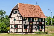
The Steinbach Alsatian House
-
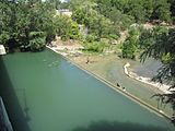
People enjoying the Medina River in Castroville.
-
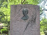
A monument honoring Henri Castro, the founder of the city.
-
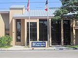
The Castroville State Bank building.
-
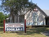
The Castroville Public Library.
-
Trees shade the entrance to the Landmark Inn, a historic site in Castroville.
-
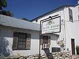
The Old Alsatian Steakhouse and Ristorante in the historic district of Castroville. This restaurant closed in 2020.
-
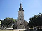
The historic St. Louis Catholic Church in downtown Castroville.
-
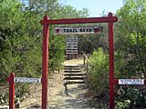
A trailhead at Castroville Regional Park.
-
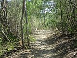
A hiking trail in Castroville Regional Park.
-
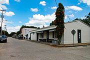
A view of downtown Castroville, Texas.


.jpg)
See also
 In Spanish: Castroville (Texas) para niños
