Lavaca Bay facts for kids
Quick facts for kids Lavaca Bay |
|
|---|---|
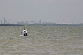
Lavaca Bay toward Point Comfort
|
|
| Location | Texas Gulf Coast |
| Coordinates | 28°37′29″N 96°35′05″W / 28.624761°N 96.584759°W |
| River sources | Lavaca River, Garcitas Creek |
| Ocean/sea sources | Gulf of Mexico |
| Basin countries | United States |
| Settlements | Port Lavaca, Point Comfort |
Lavaca Bay is a large bay in Calhoun County, Texas, USA. It's connected to the bigger Matagorda Bay. Important towns like Port Lavaca and Point Comfort are located right on its shores. Long ago, towns like Linnville and Indianola were here. But they were later abandoned or destroyed by a big hurricane. Smaller communities like Olivia, Alamo Beach, and Magnolia Beach also dot the bay's edge. The bay is about 82 miles (132 km) northeast of Corpus Christi. It's also about 121 miles (195 km) southwest of Houston and 145 miles (233 km) southeast of San Antonio.
In the late 1680s, a French explorer named René-Robert Cavelier, Sieur de La Salle tried to build a colony here. It was called Fort St. Louis. Later, in 1996, archaeologists found eight French cannons at a site believed to be the fort. They dug there from 1996 to 2002. They think a Spanish fort, Presidio La Bahía, was built right on top of La Salle's settlement. About 10% of the items found were from France.
Lavaca Bay is also known for a special cleanup site. This is because of mercury pollution from factories in Point Comfort. Even though fishing has slowed down, the bay still has many fish. Environmental groups and the government are working with companies like Alcoa to clean up the polluted areas.
Contents
History of Lavaca Bay
Lavaca Bay formed after the last ice age. The sea level rose and flooded the area where the Lavaca River and Garcitas Creek flow. The name "Lavaca" comes from a Spanish word. It means "cow" and was given by French explorer La Salle. He saw many bison, which are like wild cows, near the bay.
It's believed that La Salle built his Fort St. Louis colony near the bay. It was on Garcitas Creek. The first big town on the bay was New Port. It was started in 1831 by an Irish merchant named John J. Linn. This town was later renamed Linnville. By 1839, about 200 people lived there. It was an important place for trade during the early days of the Republic of Texas. Many famous Texans, like future San Antonio Mayor Samuel Maverick, had businesses there. But the town was destroyed in 1840 by Comanche Indians. After that, it was abandoned.
Port Lavaca grew after Linnville was abandoned. It became very important for shipping. It was also a national leader in shrimp production. Across the bay is Point Comfort. It became a city in 1953. Point Comfort is known for its large aluminum and chemical factories. These were built in the 1960s.
The small town of Olivia was founded in 1892. It was started by Swedish Lutherans. It is located on the shores of Keller Bay. Other small towns include Alamo Beach and Magnolia Beach. Alamo Beach started around 1900. Magnolia Beach was named for the magnolia trees in the area. These towns are north of the old town of Indianola, which is now a ghost town.
What Makes Lavaca Bay Special
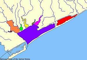
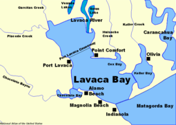
Lavaca Bay is the biggest part of the Matagorda Bay system. It has smaller parts like Chocolate Bay, Cox Bay, and Keller Bay. The Lavaca River, Garcitas Creek, and Venado Creek bring fresh water into the bay from the north. Channels have been dug to connect the bay to the Intracoastal Waterway. This waterway runs to the south. On average, the bay is about 4 feet (1.2 meters) deep.
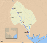
Most of Lavaca Bay has a muddy bottom. It also has many oyster reefs. There are also islands made from dirt dug up when canals were created. The shores have grassy hills and many trees. The Lavaca River flows into the bay near the Port Lavaca Causeway. This causeway crosses the bay from Port Lavaca to Point Comfort. The river flows 115 miles (185 km) from its start. It drains about 2,280 square miles (5,900 km²) of land into Lavaca Bay.
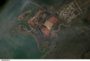
South of the Port Lavaca Causeway, in Point Comfort, there are many factories. These line the coast to Cox Bay. South of Cox Bay is the larger Keller Bay. This part extends the bay to its easternmost point near Olivia. Across the bay, the Matagorda Ship Channel runs through the middle. The town of Magnolia Beach is found on the western shore. To the northwest is Alamo Beach. It is located on Gailinipper Point. From this point, a large oyster reef stretches across the bay to Point Comfort. Port Lavaca is found north of Chocolate Bay. North of the causeway is a large round part of the bay. Garcitas Cove is in the northwest, fed by Garcitas Creek. Venado Creek also flows into the bay.
Bay Life and Environment
Lavaca Bay is home to many kinds of fish. These include Black drum, Flounder, Redfish, Sheepshead, and Speckled trout. However, the bay has a problem with mercury pollution. An Alcoa factory in Point Comfort used to release a lot of mercury into the bay. This affected about 64 square miles (166 km²).
Because of this, a special cleanup site was created. It was made illegal to process oysters and blue crab in some areas. One study showed that the mud at the bottom of the bay was much more polluted than in nearby Keller Bay.
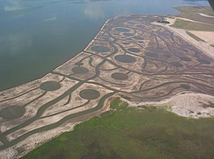
Cleaning up the pollution is a big concern for people in Calhoun County. There have been protests against the factories in Point Comfort. But Alcoa has worked with state and federal officials. They spent $110 million to make the cleanup area smaller. This was part of a deal in 2005. They are working to create more salt marsh and oyster reef habitats.
Locals believe that only the area right near the Alcoa plant is still affected. Signs warn boaters about the water's pollution there. The bad reputation of the bay has made fewer people fish there. This has actually helped the fish population grow healthy.
Industry and Economy
There is a lot of industry around Lavaca Bay. There are many natural gas and oil wells. Natural gas was found here in 1934, and oil in 1935. Point Comfort has several factories along its shore. These include Alcoa, Union Carbide, Du Pont, and Formosa Plastics Corp.
Even with fishing limits in some areas, seafood harvesting is still a big industry. However, it's not as big as it was in the 1920s. Back then, Port Lavaca was a national leader in shrimp production. Today, shrimping is only allowed south of the Port Lavaca Causeway. This is because the northern part is a nursery area for young shrimp. Shellfish can be harvested in Keller Bay and south of Point Comfort. But it's restricted along the eastern and northern coast and in Chocolate Bay. Other areas are sometimes approved for harvesting.
A small tourism industry also helps the local economy. The Port Lavaca State Fishing Pier is a popular spot. This pier was once the causeway across the bay. It was replaced in the 1960s and turned into a fishing pier. It was once said to be the longest in the world, at 3,200 feet (975 meters). Today, only parts of the old pier remain next to the modern causeway.
 | Charles R. Drew |
 | Benjamin Banneker |
 | Jane C. Wright |
 | Roger Arliner Young |


