Hondo, Texas facts for kids
Quick facts for kids
Hondo, Texas
|
|
|---|---|

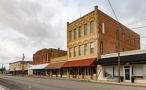
Downtown Hondo
|
|

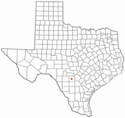
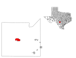
Location of Hondo, Texas
|
|
 |
|
| Country | |
| State | |
| County | Medina |
| Government | |
| • Type | Council-Manager |
| Area | |
| • Total | 10.08 sq mi (26.10 km2) |
| • Land | 10.05 sq mi (26.03 km2) |
| • Water | 0.03 sq mi (0.07 km2) |
| Elevation | 902 ft (275 m) |
| Population
(2020)
|
|
| • Total | 8,289 |
| • Density | 822.3/sq mi (317.59/km2) |
| Time zone | UTC-6 (Central (CST)) |
| • Summer (DST) | UTC-5 (CDT) |
| ZIP code |
78861
|
| Area code(s) | 830 |
| FIPS code | 48-34676 |
| GNIS feature ID | 2410784 |
| Website | hondo-tx.org |
Hondo is a city in Texas, United States. It is the main town, or county seat, of Medina County. In 2020, about 8,289 people lived there. Hondo is also part of the larger San Antonio metropolitan area.
Contents
History of Hondo
The land where Hondo is now located was first home to the Coahuiltecan people. Later, settlers came from places like Alsace-Lorraine, Germany, Belgium, and Mexico. Many families in Hondo today are descendants of these early settlers and still own the same businesses, farms, and ranches.
Early Explorers and Settlement
The first European to explore this area was Cabeza de Vaca in the early 1530s. This was about 40 years after Christopher Columbus arrived in the New World. The city of Hondo itself was first settled in 1881 and officially became a city in 1942.
Famous Bank Robberies
In the early 1920s, Hondo was the site of two bank robberies. These crimes were carried out by the Newton Gang, a well-known group of outlaws in U.S. history. Both robberies happened on the same night.
The Famous Hondo Sign
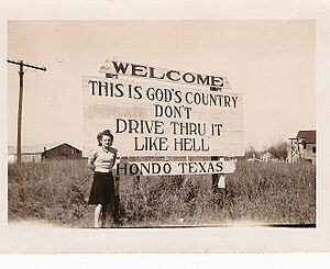
In 1930, the local Hondo Lions Club put up a famous sign at the city limits. It originally said, "This is God's Country, Don't Drive Thru It Like Hell." The idea was to encourage drivers to slow down. Later, in the 1940s, the sign was changed to a softer message: "This is God's Country, Please Don't Drive Through It Like Hell." This change was made to please some town residents who didn't like the original wording. This sign has been featured in many magazines, including on the cover of National Geographic. It even appeared in the music video for the song "God Blessed Texas" by the band Little Texas.
Hondo Army Air Field
During World War II, the U.S. Army built an air field in Hondo in 1942. This field was used to train new pilots. At one point, it was the largest air navigation school in the world. Over 14,000 navigators were trained here before the field closed in 1946.
Geography and Location
Hondo is located about 40 miles (64 km) west of Downtown San Antonio. The city covers an area of about 9.6 square miles (24.9 km²), with most of it being land and a small part covered by water. Hondo was once described on the TV show The Night Shift as "a two stoplight town down I-90," which gives you an idea of its size.
Climate in Hondo
Hondo has a climate known as a humid subtropical climate. This means it has hot, humid summers and winters that are generally mild to cool.
| Climate data for Hondo, Texas (South Texas Regional Airport at Hondo) (1991–2020 normals, extremes 1900–present) | |||||||||||||
|---|---|---|---|---|---|---|---|---|---|---|---|---|---|
| Month | Jan | Feb | Mar | Apr | May | Jun | Jul | Aug | Sep | Oct | Nov | Dec | Year |
| Record high °F (°C) | 90 (32) |
98 (37) |
102 (39) |
105 (41) |
106 (41) |
107 (42) |
112 (44) |
111 (44) |
112 (44) |
102 (39) |
99 (37) |
93 (34) |
112 (44) |
| Mean maximum °F (°C) | 81.3 (27.4) |
85.9 (29.9) |
89.8 (32.1) |
93.6 (34.2) |
96.8 (36.0) |
99.6 (37.6) |
101.2 (38.4) |
102.5 (39.2) |
99.1 (37.3) |
94.1 (34.5) |
85.9 (29.9) |
81.2 (27.3) |
103.9 (39.9) |
| Mean daily maximum °F (°C) | 65.3 (18.5) |
69.7 (20.9) |
75.8 (24.3) |
82.7 (28.2) |
88.3 (31.3) |
94.4 (34.7) |
96.7 (35.9) |
97.2 (36.2) |
91.4 (33.0) |
83.8 (28.8) |
73.3 (22.9) |
65.6 (18.7) |
82.0 (27.8) |
| Daily mean °F (°C) | 52.0 (11.1) |
56.6 (13.7) |
63.0 (17.2) |
69.8 (21.0) |
76.9 (24.9) |
82.8 (28.2) |
84.7 (29.3) |
84.8 (29.3) |
79.6 (26.4) |
71.4 (21.9) |
60.6 (15.9) |
52.9 (11.6) |
69.6 (20.9) |
| Mean daily minimum °F (°C) | 38.7 (3.7) |
43.4 (6.3) |
50.2 (10.1) |
56.9 (13.8) |
65.6 (18.7) |
71.2 (21.8) |
72.6 (22.6) |
72.3 (22.4) |
67.7 (19.8) |
58.9 (14.9) |
47.9 (8.8) |
40.1 (4.5) |
57.1 (13.9) |
| Mean minimum °F (°C) | 22.5 (−5.3) |
26.2 (−3.2) |
30.9 (−0.6) |
39.0 (3.9) |
50.2 (10.1) |
62.9 (17.2) |
67.2 (19.6) |
66.4 (19.1) |
54.7 (12.6) |
39.5 (4.2) |
29.1 (−1.6) |
23.6 (−4.7) |
19.8 (−6.8) |
| Record low °F (°C) | 4 (−16) |
4 (−16) |
13 (−11) |
29 (−2) |
38 (3) |
47 (8) |
57 (14) |
55 (13) |
43 (6) |
23 (−5) |
19 (−7) |
7 (−14) |
4 (−16) |
| Average precipitation inches (mm) | 1.21 (31) |
1.27 (32) |
1.88 (48) |
2.10 (53) |
3.43 (87) |
2.94 (75) |
2.06 (52) |
1.93 (49) |
2.76 (70) |
2.59 (66) |
1.56 (40) |
1.18 (30) |
24.91 (633) |
| Average precipitation days (≥ 0.01 in) | 5.9 | 5.7 | 7.0 | 5.6 | 7.7 | 6.0 | 4.9 | 4.5 | 6.8 | 5.5 | 5.9 | 5.9 | 71.4 |
| Source: NOAA | |||||||||||||
Population and People
| Historical population | |||
|---|---|---|---|
| Census | Pop. | %± | |
| 1950 | 4,188 | — | |
| 1960 | 4,992 | 19.2% | |
| 1970 | 5,487 | 9.9% | |
| 1980 | 6,057 | 10.4% | |
| 1990 | 6,018 | −0.6% | |
| 2000 | 7,897 | 31.2% | |
| 2010 | 8,803 | 11.5% | |
| 2020 | 8,289 | −5.8% | |
| U.S. Decennial Census | |||
As of the 2020 United States census, Hondo had a population of 8,289 people. The city is home to a diverse community with many different backgrounds.
Education in Hondo
Students in Hondo attend schools within the Hondo Independent School District. The local high school is Hondo High School, and their sports teams are known as the Owls.
Getting Around Hondo
Roads
U.S. Route 90 runs through the middle of Hondo as 19th Street. If you go west on this road, you'll reach Sabinal in about 20 miles (32 km). If you head east, you'll get to Castroville in about 16 miles (26 km) and San Antonio in roughly 40 miles (65 km). Texas State Highway 173 is just east of the city. It goes north to Bandera (29 miles or 47 km) and south to Devine (21 miles or 34 km).
Airports
The closest airport with flights for travelers is San Antonio International Airport. This airport is about 46 miles (74 km) east of Hondo, on the north side of San Antonio. Hondo also has its own public airport, called South Texas Regional Airport at Hondo.
Notable People from Hondo
- Clint Hartung (1947–1952), a baseball pitcher and outfielder, was born in Hondo.
- George C. Windrow (1931–2019), who was a member of the Wisconsin State Assembly, was also born in Hondo.
See also
 In Spanish: Hondo (Texas) para niños
 | Selma Burke |
 | Pauline Powell Burns |
 | Frederick J. Brown |
 | Robert Blackburn |


