
Victoria County, Texas facts for kids
Quick facts for kids
Victoria County
|
|
|---|---|

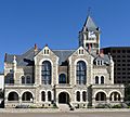
The Victoria County Courthouse of Romanesque revival design in Victoria
|
|

Location within the U.S. state of Texas
|
|
 Texas's location within the U.S. |
|
| Country | |
| State | |
| Founded | 1836 |
| Named for | Guadalupe Victoria |
| Seat | Victoria |
| Largest city | Victoria |
| Area | |
| • Total | 889 sq mi (2,300 km2) |
| • Land | 882 sq mi (2,280 km2) |
| • Water | 6.7 sq mi (17 km2) 0.8%% |
| Population
(2020)
|
|
| • Total | 91,319 |
| • Density | 102.72/sq mi (39.661/km2) |
| Time zone | UTC−6 (Central) |
| • Summer (DST) | UTC−5 (CDT) |
| Congressional district | 27th |
Victoria County is a county located in the U.S. state of Texas. In 2020, about 91,319 people lived there. The main city and county seat is also called Victoria. Victoria County is part of the Victoria, TX Metropolitan Statistical Area. It also makes up the entire Victoria, TX media market.
Contents
History of Victoria County
Victoria County has a long and interesting history. Many different groups of people have lived here over thousands of years.
- Long ago, Paleo-Indians and later tribes like the Tonkawa, Karankawa, and Comanche were the first inhabitants. They lived as hunter-gatherers.
- In 1685, a French explorer named René-Robert Cavelier, Sieur de La Salle built Fort St. Louis in the area.
- In 1689, Alonso de Leon named the Guadalupe River.
- The first Spanish settlements, Nuestra Señora de Loreto Presidio and Mission Nuestra Señora del Espíritu Santo de Zúñiga, were built in 1722.
- In 1824, the city of Victoria was founded by Martín De León. He brought 5,000 cattle, making the county famous for its cattle industry. His colony was the only one in Texas mainly settled by Mexicans.
- In 1835, settlers in Victoria supported the fight against Antonio López de Santa Anna. However, after the revolution in 1836, many were forced to leave.
- Victoria County was officially formed in 1836 by the Republic of Texas. It was named after Guadalupe Victoria, who was the first President of Mexico.
- In 1842, Mexican forces led by Rafael Vásquez and Adrián Woll entered the county.
- Coletoville was started in 1850 by a German immigrant named Carl Steiner.
- The first toll bridge in Victoria County was built over the river in 1851.
- In 1861, the county voted to leave the Union and join the Confederacy. Victoria County sent 300 men to fight in the American Civil War.
- During the Civil War in 1863, Confederate General John B. Magruder destroyed the railroad from Port Lavaca to Victoria to keep it from Union forces.
- After the war, federal troops occupied the county from 1867 to 1869.
- In 1873, the Gulf, Western Texas and Pacific Railway connected Victoria with Cuero and the coast.
- The New York, Texas and Mexican Railway provided a new route to Rosenberg Junction in Fort Bend County in 1882.
- In 1883, the Texas Continental Meat Company opened. It was the largest meat packing plant in Texas.
- Oil was found at the McFaddin Oil Field in 1930. At this time, Victoria County had more cattle than any other county in Texas.
- Foster Air Force Base was established in 1941 as a training air field.
- The Victoria Barge Canal was finished in 1967. This canal connects Victoria County to the Intracoastal Waterway.
People of Victoria County
| Historical population | |||
|---|---|---|---|
| Census | Pop. | %± | |
| 1850 | 2,019 | — | |
| 1860 | 4,171 | 106.6% | |
| 1870 | 4,860 | 16.5% | |
| 1880 | 6,289 | 29.4% | |
| 1890 | 8,737 | 38.9% | |
| 1900 | 13,678 | 56.6% | |
| 1910 | 14,990 | 9.6% | |
| 1920 | 18,271 | 21.9% | |
| 1930 | 20,048 | 9.7% | |
| 1940 | 23,741 | 18.4% | |
| 1950 | 31,241 | 31.6% | |
| 1960 | 46,475 | 48.8% | |
| 1970 | 53,766 | 15.7% | |
| 1980 | 68,807 | 28.0% | |
| 1990 | 74,361 | 8.1% | |
| 2000 | 84,088 | 13.1% | |
| 2010 | 86,793 | 3.2% | |
| 2020 | 91,319 | 5.2% | |
| U.S. Decennial Census 1850–2010 2010–2014 |
|||
How Many People Live Here?
| Race / Ethnicity (NH = Non-Hispanic) | Pop 2000 | Pop 2010 | Pop 2020 | % 2000 | % 2010 | % 2020 |
|---|---|---|---|---|---|---|
| White alone (NH) | 44,490 | 41,564 | 39,330 | 52.91% | 47.89% | 43.07% |
| Black or African American alone (NH) | 5,137 | 5,190 | 5,230 | 6.11% | 5.98% | 5.73% |
| Native American or Alaska Native alone (NH) | 197 | 199 | 425 | 0.23% | 0.23% | 0.23% |
| Asian alone (NH) | 635 | 860 | 2,404 | 0.76% | 0.99% | 1.52% |
| Pacific Islander alone (NH) | 9 | 16 | 46 | 0.01% | 0.02% | 0.04% |
| Other Race alone (NH) | 39 | 109 | 698 | 0.05% | 0.13% | 0.25% |
| Mixed race or Multiracial alone (NH) | 622 | 742 | 7,961 | 0.74% | 0.85% | 2.14% |
| Hispanic or Latino (any race) | 32,959 | 38,113 | 42,931 | 39.20% | 43.91% | 47.01% |
| Total | 84,088 | 86,793 | 91,319 | 100.00% | 100.00% | 100.00% |
In 2020, there were 91,319 people living in Victoria County. There were 32,520 households and 22,172 families.
Back in 2000, there were 84,088 people. The county had about 95 people per square mile. Most people were White (74.22%), with Black or African American people making up 6.30%. About 39.20% of the population was Hispanic or Latino.
Many people in Victoria County have German (16.2%), American (6.2%), and English (5.6%) backgrounds. Most people (73.3%) spoke English, and 25.5% spoke Spanish as their first language.
In 2000, about 37.20% of households had children under 18. The average household had 2.75 people. The average family had 3.23 people.
The population was spread out by age. About 29.10% were under 18 years old. The median age was 34 years. This means half the people were younger than 34 and half were older.
Geography of Victoria County
Victoria County covers a total area of 889 square miles. Most of this area, 882 square miles, is land. The remaining 6.7 square miles (0.8%) is water.
Main Roads
 U.S. Highway 59
 A future highway, Interstate 69, will mostly follow U.S. 59 northeast of Victoria.
 Another future highway, Interstate 69W, will mostly follow U.S. 59 southwest of Victoria.
 U.S. Highway 77
 The future Interstate 69E will mostly follow U.S. 77 southwest of Victoria.
 U.S. Highway 87
 Farm to Market Road 444
 Farm to Market Road 616
 Farm to Market Road 622
Neighboring Counties
Victoria County shares borders with several other counties:
- Lavaca County (to the north)
- Jackson County (to the northeast)
- Calhoun County (to the southeast)
- Refugio County (to the south)
- Goliad County (to the southwest)
- DeWitt County (to the northwest)
Education
Students in Victoria County attend schools in several different school districts:
- Bloomington Independent School District
- Industrial Independent School District
- Meyersville Independent School District
- Nursery Independent School District
- Refugio Independent School District
- Victoria Independent School District
For higher education, the entire county is served by Victoria College. Also, the University of Houston-Victoria is located in the city of Victoria.
Images for kids
-
The Victoria County Courthouse of Romanesque revival design in Victoria
See also
 In Spanish: Condado de Victoria (Texas) para niños
