Goliad County, Texas facts for kids
Quick facts for kids
Goliad County
|
|
|---|---|

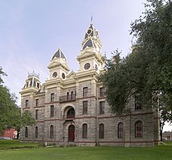
The Goliad County Courthouse in Goliad. The courthouse and the surrounding square were added to the National Register of Historic Places on June 29, 1976.
|
|

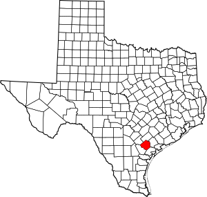
Location within the U.S. state of Texas
|
|
 Texas's location within the U.S. |
|
| Country | |
| State | |
| Founded | 1837 |
| Named for | Miguel Hidalgo |
| Seat | Goliad |
| Largest city | Goliad |
| Area | |
| • Total | 859 sq mi (2,220 km2) |
| • Land | 852 sq mi (2,210 km2) |
| • Water | 7.4 sq mi (19 km2) 0.9% |
| Population
(2020)
|
|
| • Total | 7,012 |
| • Density | 8.163/sq mi (3.1517/km2) |
| Time zone | UTC−6 (Central) |
| • Summer (DST) | UTC−5 (CDT) |
| Congressional district | 27th |
Goliad County (/ˈɡoʊliæd/ GOH-lee-ad) is a county located in the U.S. state of Texas. As of the 2020 census, its population was 7,012 people. The county seat (main town) is Goliad.
The county is named for Father Miguel Hidalgo. The name "Goliad" is actually an anagram of his last name, without the silent "H". Goliad County was created in 1836 and officially started operating in 1837. It is part of the Victoria, TX Metropolitan Statistical Area.
Contents
A Look Back at Goliad County's History
Goliad County holds a special place in Texas history. The very first declaration of independence for the Republic of Texas was signed here. This happened on December 20, 1835. The more formal declaration came later, in 1836.
Battles of the Texas Revolution
Goliad County was the site of two important battles during the Texas Revolution.
- The Battle of Goliad was a smaller fight early in the war.
- The battle of Coleto was a much bigger battle. It ended on March 27, 1836.
After the Battle of Coleto, something very sad happened. Colonel James Fannin and his Texan soldiers were captured. They were then executed by the Mexican army. This happened under orders from General Antonio López de Santa Anna. This terrible event is known as the Goliad Massacre.
This massacre led to a famous battle cry for the Texas Revolution: "Remember the Alamo! Remember Goliad!" While many people remember the Alamo today, fewer remember Goliad. The place where the massacre happened is near Presidio la Bahia. This is just south of the town of Goliad.
Birthplace of a Mexican Hero
Goliad County is also the birthplace of General Ignacio Zaragoza. He was a Mexican general who led the Mexican army to victory. He fought against the invading forces of Napoleon III of France. This famous battle was the Battle of Puebla on May 5, 1862. This day is now celebrated as "Cinco de Mayo".
Geography and Roads
Goliad County covers a total area of 859 square miles. Most of this area, about 852 square miles, is land. The remaining 7.4 square miles (less than 1%) is water.
Main Roads and Highways
Several important roads run through Goliad County. These highways help people travel and transport goods.
 U.S. Highway 59: A major route that will become part of Interstate 69W in the future.
 U.S. Highway 77 Alternate/U.S. Highway 183
 State Highway 119
 State Highway 239
 Farm to Market Road 81
 Farm to Market Road 622
 Farm to Market Road 833
Neighboring Counties
Goliad County shares its borders with several other counties:
- DeWitt County (to the north)
- Victoria County (to the northeast)
- Refugio County (to the southeast)
- Bee County (to the southwest)
- Karnes County (to the northwest)
Population and People
The population of Goliad County has changed over the years.
| Historical population | |||
|---|---|---|---|
| Census | Pop. | %± | |
| 1850 | 648 | — | |
| 1860 | 3,384 | 422.2% | |
| 1870 | 3,628 | 7.2% | |
| 1880 | 5,832 | 60.7% | |
| 1890 | 5,910 | 1.3% | |
| 1900 | 8,310 | 40.6% | |
| 1910 | 9,909 | 19.2% | |
| 1920 | 9,348 | −5.7% | |
| 1930 | 10,093 | 8.0% | |
| 1940 | 8,798 | −12.8% | |
| 1950 | 6,219 | −29.3% | |
| 1960 | 5,429 | −12.7% | |
| 1970 | 4,869 | −10.3% | |
| 1980 | 5,193 | 6.7% | |
| 1990 | 5,980 | 15.2% | |
| 2000 | 6,928 | 15.9% | |
| 2010 | 7,210 | 4.1% | |
| 2020 | 7,012 | −2.7% | |
| U.S. Decennial Census 1850–2010 2020 |
|||
As of the 2020 census, Goliad County had a population of 7,012 people. In 2000, there were 6,928 people living in the county. The population density was about 8 people per square mile.
Education
Students in Goliad County attend schools run by the Goliad Independent School District.
Communities in Goliad County
Goliad County has one main city and several smaller communities.
City
- Goliad (This is the county seat, where the main government offices are located.)
Unincorporated Communities
These are smaller towns and areas that are not officially organized as cities.
- Ander
- Angel City
- Berclair
- Charco
- Fannin
- Kilgore
- Melrose
- Sarco
- Schroeder
- Weesatche
- Weser
See also
 In Spanish: Condado de Goliad para niños
 | Toni Morrison |
 | Barack Obama |
 | Martin Luther King Jr. |
 | Ralph Bunche |

