
Goliad, Texas facts for kids
Quick facts for kids
Goliad, Texas
|
|
|---|---|
.jpg)
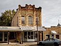
Historic district of downtown Goliad, Texas
|
|
| Motto(s):
"Birthplace of Texas Ranching"
|
|

Location of Goliad, Texas
|
|
| Country | United States |
| State | Texas |
| County | Goliad |
| Area | |
| • Total | 1.57 sq mi (4.07 km2) |
| • Land | 1.56 sq mi (4.05 km2) |
| • Water | 0.00 sq mi (0.01 km2) |
| Elevation | 164 ft (50 m) |
| Population
(2020)
|
|
| • Total | 1,620 |
| • Density | 1,032/sq mi (398.0/km2) |
| Time zone | UTC-6 (Central (CST)) |
| • Summer (DST) | UTC-5 (CDT) |
| ZIP code |
77963
|
| Area code(s) | 361 |
| FIPS code | 48-30080 |
| GNIS feature ID | 1358133 |
Goliad (pronounced GOH-lee-ad) is a city in Texas, United States. It is the main town and county seat of Goliad County, Texas. Goliad is famous for an important event in 1836 called the Goliad massacre, which happened during the Texas Revolution. In 2020, about 1,620 people lived there.
Contents
History of Goliad
Spanish Rule and Early Settlements
In 1747, the Spanish government sent a leader named José de Escandón to check on their lands in North America, including what is now Texas. He suggested moving a Spanish fort, called Presidio La Bahía, and a church mission, Mission Nuestra Señora del Espíritu Santo de Zúñiga, to a new spot. This new spot was along the San Antonio River.
The fort and mission moved in 1749. Escandón wanted families to live near the fort to create a town, but not enough people wanted to move there.
After the Seven Years' War ended in 1763, France gave up its claims to Texas and Louisiana to Spain. Spain no longer worried about France. So, a Spanish official named Marquis de Rubi checked all the forts. He said that Presidio La Bahía should be rebuilt with strong stone.
This fort became very important. It was the only Spanish fort along the entire Gulf Coast from the Rio Grande to the Mississippi River. It was also at a key meeting point for trade and military paths. Soon, a town called La Bahía grew around the fort. By 1804, this town had one of only two schools in all of Texas.
Changes During Mexican Independence
In 1812, during the Mexican War of Independence, a Mexican rebel leader named Bernardo Gutiérrez de Lara and his army invaded Texas. They captured Presidio La Bahía. The Texas governor, Manuel María de Salcedo, tried to take the fort back for four months but couldn't.
The rebels held the fort until 1813. Then, royalist troops led by José Joaquín de Arredondo took back control of Texas. Later, in 1817, another group tried to capture La Bahía but was defeated.
In 1821, the United States and Spain signed a treaty. This treaty meant the U.S. gave up its claims to Texas. Later that year, Mexico won its independence from Spain. Texas then became part of the new country of Mexico.
Goliad's Role in the Texas Revolution
In 1829, the town of La Bahía in Mexican Texas got a new name: "Goliad." This name is believed to be an anagram of "Hidalgo," honoring Miguel Hidalgo. He was a very important priest and leader in Mexico's fight for independence.
On October 9, 1835, at the start of the Texas Revolution, a group of Anglo-American settlers attacked the fort in an event known as the Battle of Goliad. The Mexican soldiers quickly gave up, and the settlers took control of the fort.
On December 20, 1835, the first Goliad Declaration of Independence for the Republic of Texas was signed here. Right after, a flag called the "Bloody Arm Flag" was raised over Presidio La Bahía.
The Anglo-Americans held the area until March 1836. Their leader, James Fannin, and his soldiers were defeated at the nearby Battle of Coleto. The President of Mexico, Antonio Lopez de Santa Anna, ordered that the captured soldiers be killed. On March 27, 1836, in what became known as the Goliad Massacre, many soldiers were killed outside and inside the fort. Some doctors and medical helpers were spared.
Later History and Notable People
A famous Mexican General, Ignacio Zaragoza, was born in Goliad in 1829. He led the Mexican army against the French in the Battle of Puebla in 1862. This battle is now celebrated as Cinco de Mayo.
The Texas gunfighter King Fisher also lived in Goliad for a time.
The 1902 Goliad Tornado
In 1902, a very strong tornado hit Goliad. It killed 114 people and injured at least 225. This tornado is one of the deadliest in Texas history. A young doctor, Louis Warren Chilton, helped many people. He set up a temporary hospital in the courthouse. His own house was built with an underground shelter after the tornado.
Geography and Climate

Goliad is located in the middle of Goliad County. U.S. Route 59 goes through the town. It leads northeast to Victoria and southwest to Beeville. The San Antonio River flows along the southern edge of the city.
Goliad has a humid subtropical climate. This means it has hot, humid summers and mild to cool winters.
| Climate data for Goliad, Texas (1991–2020 normals, extremes 1937–2014) | |||||||||||||
|---|---|---|---|---|---|---|---|---|---|---|---|---|---|
| Month | Jan | Feb | Mar | Apr | May | Jun | Jul | Aug | Sep | Oct | Nov | Dec | Year |
| Record high °F (°C) | 90 (32) |
97 (36) |
99 (37) |
105 (41) |
102 (39) |
112 (44) |
112 (44) |
112 (44) |
111 (44) |
102 (39) |
96 (36) |
89 (32) |
112 (44) |
| Mean daily maximum °F (°C) | 65.6 (18.7) |
69.6 (20.9) |
75.1 (23.9) |
81.1 (27.3) |
86.8 (30.4) |
91.6 (33.1) |
94.7 (34.8) |
96.1 (35.6) |
90.9 (32.7) |
84.3 (29.1) |
74.7 (23.7) |
67.5 (19.7) |
81.5 (27.5) |
| Daily mean °F (°C) | 54.4 (12.4) |
58.3 (14.6) |
64.3 (17.9) |
70.7 (21.5) |
77.1 (25.1) |
82.0 (27.8) |
84.3 (29.1) |
85.0 (29.4) |
80.5 (26.9) |
72.6 (22.6) |
63.2 (17.3) |
56.1 (13.4) |
70.7 (21.5) |
| Mean daily minimum °F (°C) | 43.3 (6.3) |
47.0 (8.3) |
53.4 (11.9) |
60.4 (15.8) |
67.4 (19.7) |
72.5 (22.5) |
73.8 (23.2) |
73.8 (23.2) |
70.1 (21.2) |
60.9 (16.1) |
51.8 (11.0) |
44.7 (7.1) |
59.9 (15.5) |
| Record low °F (°C) | 7 (−14) |
13 (−11) |
20 (−7) |
32 (0) |
42 (6) |
55 (13) |
61 (16) |
61 (16) |
44 (7) |
23 (−5) |
20 (−7) |
8 (−13) |
7 (−14) |
| Average precipitation inches (mm) | 2.71 (69) |
1.73 (44) |
2.74 (70) |
2.67 (68) |
4.54 (115) |
3.90 (99) |
2.95 (75) |
3.41 (87) |
4.69 (119) |
3.41 (87) |
2.33 (59) |
2.13 (54) |
37.21 (945) |
| Average snowfall inches (cm) | 0.0 (0.0) |
0.0 (0.0) |
0.0 (0.0) |
0.0 (0.0) |
0.0 (0.0) |
0.0 (0.0) |
0.0 (0.0) |
0.0 (0.0) |
0.0 (0.0) |
0.0 (0.0) |
0.0 (0.0) |
0.0 (0.0) |
0.0 (0.0) |
| Average precipitation days (≥ 0.01 in) | 7.1 | 6.9 | 6.1 | 5.0 | 5.3 | 7.0 | 6.4 | 5.9 | 8.0 | 6.5 | 5.7 | 6.7 | 76.6 |
| Average snowy days (≥ 0.1 in) | 0.0 | 0.0 | 0.0 | 0.0 | 0.0 | 0.0 | 0.0 | 0.0 | 0.0 | 0.0 | 0.0 | 0.0 | 0.0 |
| Source: NOAA | |||||||||||||
Population of Goliad
| Historical population | |||
|---|---|---|---|
| Census | Pop. | %± | |
| 1880 | 885 | — | |
| 1930 | 1,424 | — | |
| 1940 | 1,446 | 1.5% | |
| 1950 | 1,584 | 9.5% | |
| 1960 | 1,782 | 12.5% | |
| 1970 | 1,709 | −4.1% | |
| 1980 | 1,990 | 16.4% | |
| 1990 | 1,946 | −2.2% | |
| 2000 | 1,975 | 1.5% | |
| 2010 | 1,908 | −3.4% | |
| 2020 | 1,604 | −15.9% | |
| U.S. Decennial Census | |||
In 2020, the city of Goliad had 1,620 people living there. There were 713 households and 420 families.
| Race | Number | Percentage |
|---|---|---|
| White (NH) | 649 | 40.06% |
| Black or African American (NH) | 89 | 5.49% |
| Native American or Alaska Native (NH) | 5 | 0.31% |
| Asian (NH) | 6 | 0.37% |
| Some Other Race (NH) | 2 | 0.12% |
| Mixed/Multi-Racial (NH) | 41 | 2.53% |
| Hispanic or Latino | 828 | 51.11% |
| Total | 1,620 |
Education in Goliad
The schools in Goliad are part of the Goliad Independent School District [1].
Fun Things to Do in Goliad
- Goliad Market Day is held on the second Saturday of every month. You can find fresh produce, arts and crafts, and other items for sale.
- Schroeder Hall is a very old and famous dance hall in Texas. Many legendary country music stars have performed there. It still hosts big names in country music today.
- Goliad Brewing Company Beer Garden is open to the public on Fridays and Saturdays.
Images for kids
-
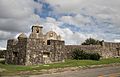
Presidio Nuestra Señora De Loreto De La Bahia
-
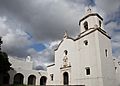
Nuestra Senora del Espiritu Santo de Zuniga Site
-
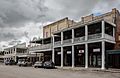
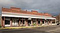
Downtown Goliad, Texas
-
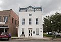
Masonic Lodge building in downtown
-
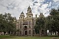
Goliad County Courthouse
-
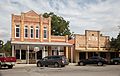
Downtown Goliad, Texas
-
Goliad County Library
-
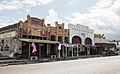
Downtown Goliad, Texas
-

Von Dohlen Building
-
Bergmann Building
-
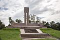
Goliad Massacre Monument
.jpg)
.jpg)
.jpg)
.jpg)
.jpg)
.jpg)
.jpg)
.jpg)
.jpg)
.jpg)
.jpg)
See also
 In Spanish: Goliad (Texas) para niños
