
DeWitt County, Texas facts for kids
Quick facts for kids
DeWitt County
|
|
|---|---|

The DeWitt County Courthouse located in Cuero. The courthouse was added to the National Register of Historic Places on May 6, 1971.
|
|

Location within the U.S. state of Texas
|
|
 Texas's location within the U.S. |
|
| Country | |
| State | |
| Founded | 1846 |
| Named for | Green DeWitt |
| Seat | Cuero |
| Largest city | Cuero |
| Area | |
| • Total | 910 sq mi (2,400 km2) |
| • Land | 909 sq mi (2,350 km2) |
| • Water | 1.5 sq mi (4 km2) 0.2%% |
| Population
(2020)
|
|
| • Total | 19,824 |
| • Density | 21.8/sq mi (8.4/km2) |
| Time zone | UTC−6 (Central) |
| • Summer (DST) | UTC−5 (CDT) |
| Congressional district | 27th |
DeWitt County is a special area called a county in the state of Texas. In 2020, about 19,824 people lived here. The main town, or county seat, is Cuero. The county started in 1846. It is named after Green DeWitt, who helped set up an early settlement in Texas.
Contents
History
Early People
Long ago, Paleo-Indians lived here. They were hunter-gatherers, meaning they hunted animals and gathered plants for food. Later, different Native American groups called the Tonkawa, Aranamas, Tamiques, Karankawa, Tawakoni, Lipan Apache, and Comanche lived and hunted in this area.
First European Visitors
The first Europeans to visit DeWitt County were likely explorers. These included Álvar Núñez Cabeza de Vaca and his companions in 1528. They were part of a Spanish trip that went wrong. Later, a French explorer named René Robert Cavelier, Sieur de La Salle might have traveled through the county. He was on his way west from Victoria County.
County Begins and Grows
In 1825, a person named Green DeWitt got permission to bring 400 families to settle here. This was from the government of Coahuila y Tejas, which was part of Mexico at the time. Between 1826 and 1831, settlers came from places like Tennessee, Kentucky, Missouri, and other southern states.
A temporary county government started in 1846. The first county seat was a store owned by Daniel Boone Friar. Later, in 1850, Clinton became the county seat. But in 1876, Cuero became the main town for the county.
DeWitt County supported Texas leaving the Union during the American Civil War. Many local military groups joined the fight. After the war, during a time called Reconstruction, soldiers were stationed in the county.
From 1866 to 1868, a special office called the Freedmen's Bureau helped formerly enslaved people in Clinton. A community called Hopkinsville was started in 1872 by Henry Hopkins, a freedman. People there built a school and the Antioch Baptist Church.
A long-lasting conflict happened in the county. It involved the Taylor and Sutton families. This dispute lasted for about ten years. It was a very famous conflict in Texas history.
On April 1, 1866, the first cattle drive on the Chisholm Trail began near Cuero. Cowboys drove large groups of cattle along this trail. But when railroads came, the cattle drives were no longer needed. The first train line in DeWitt County was the Gulf, Western Texas and Pacific. More lines followed, and by 1925, they were all part of the Southern Pacific lines. Passenger trains ran until 1950.
During World War II, the United States Army Air Corps opened Cuero Field in 1941. It was a pilot training school at the Cuero Municipal Airport. It closed in 1944.
Cuero is known as the "Turkey Capital of the World." This is because of its large turkey farming industry. In the past, turkey farmers would drive their turkeys down Main Street to the packing plant. This was like the cattle drives! People loved to watch thousands of turkeys go through town. The first Cuero Turkey Trot celebration started in 1912. Today, it's a big festival with parades, music, food, and dances.
Geography
DeWitt County covers about 910 square miles. Most of this area, 909 square miles, is land. Only a small part, about 1.5 square miles, is water.
Main Roads
 U.S. Highway 87

 U.S. Highway 77 Alternate/U.S. Highway 183
 State Highway 72
 State Highway 119
Neighboring Counties
DeWitt County shares borders with these other counties:
- Lavaca County (to the northeast)
- Victoria County (to the southeast)
- Goliad County (to the south)
- Karnes County (to the southwest)
- Gonzales County (to the northwest)
Population Information
| Historical population | |||
|---|---|---|---|
| Census | Pop. | %± | |
| 1850 | 1,716 | — | |
| 1860 | 5,108 | 197.7% | |
| 1870 | 6,443 | 26.1% | |
| 1880 | 10,082 | 56.5% | |
| 1890 | 14,307 | 41.9% | |
| 1900 | 21,311 | 49.0% | |
| 1910 | 23,501 | 10.3% | |
| 1920 | 27,971 | 19.0% | |
| 1930 | 27,441 | −1.9% | |
| 1940 | 24,935 | −9.1% | |
| 1950 | 22,973 | −7.9% | |
| 1960 | 20,683 | −10.0% | |
| 1970 | 18,660 | −9.8% | |
| 1980 | 18,903 | 1.3% | |
| 1990 | 18,840 | −0.3% | |
| 2000 | 20,013 | 6.2% | |
| 2010 | 20,097 | 0.4% | |
| 2020 | 19,824 | −1.4% | |
| U.S. Decennial Census 1850–2010 2020 |
|||
| Race / Ethnicity (NH = Not Hispanic) | Pop 2000 | Pop 2010 | Pop 2020 | % 2000 | % 2010 | % 2020 |
|---|---|---|---|---|---|---|
| White alone (NH) | 12,168 | 11,482 | 10,854 | 60.80% | 57.13% | 54.75% |
| Black or African American alone (NH) | 2,158 | 1,781 | 1,557 | 10.78% | 8.86% | 7.85% |
| Native American or Alaska Native alone (NH) | 63 | 43 | 32 | 0.31% | 0.21% | 0.16% |
| Asian alone (NH) | 34 | 44 | 70 | 0.17% | 0.22% | 0.35% |
| Pacific Islander alone (NH) | 5 | 0 | 2 | 0.02% | 0.00% | 0.01% |
| Other race alone (NH) | 7 | 96 | 35 | 0.03% | 0.48% | 0.18% |
| Mixed race or Multiracial (NH) | 126 | 149 | 384 | 0.63% | 0.74% | 1.94% |
| Hispanic or Latino (any race) | 5,432 | 6,502 | 6,890 | 27.24% | 32.35% | 34.76% |
| Total | 20,013 | 20,097 | 19,824 | 100.00% | 100.00% | 100.00% |
In 2000, there were 20,013 people living in DeWitt County. There were 7,207 households, which are groups of people living together. About 5,131 of these were families. The county had about 22 people per square mile.
Most people in the county were White (76.4%). About 11.0% were African American. About 27.2% of the people were Hispanic or Latino. Many people had German roots (28.0%). Most people spoke English (77.2%). Some spoke Spanish (20.5%) or German (1.6%).
About 31.0% of households had children under 18. More than half (55.1%) were married couples. About 26.4% of households were single people living alone. The average household had 2.53 people.
The median income for a household was $28,714. This means half of the households earned more, and half earned less. For families, the median income was $33,513. About 19.6% of all people in the county lived below the poverty line. This included 25.5% of those under 18.
Education
Several school districts serve DeWitt County:
- Cuero Independent School District
- Meyersville Independent School District
- Nordheim Independent School District
- Westhoff Independent School District
- Yoakum Independent School District
- Yorktown Independent School District
Four of these districts have high schools:
- Cuero High School
- Yorktown High School (Texas)
- Nordheim High School
Students from Meyersville and Westhoff school districts go to one of these high schools. All of DeWitt County is also served by Victoria College.
Communities
Cities
- Cuero (the main town)
- Nordheim
- Yoakum (partly in Lavaca County)
- Yorktown
Small Towns and Areas
Former Town
- Clinton (now a ghost town)
Famous People
- James Dahlman: He was the mayor of Omaha, Nebraska, for many years. He was born in DeWitt County.
- Harlon Block: He was one of the Marines in the famous photo Raising the Flag on Iwo Jima. He was born in Yorktown.
- Roy Benavidez: He received the Medal of Honor for his bravery in the United States Army. He was born in Lindenau.
Images for kids
-
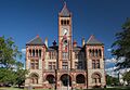
The DeWitt County Courthouse in Cuero. It's a historic building!
See also
 In Spanish: Condado de DeWitt (Texas) para niños
