Nueces Bay facts for kids
Quick facts for kids Nueces Bay |
|
|---|---|

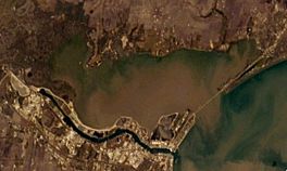
Nueces Bay from Space
|
|
| Location | South Texas Gulf Coast |
| Coordinates | 27°51′02″N 97°25′58″W / 27.85056°N 97.43278°W |
| River sources | Nueces River |
| Ocean/sea sources | Gulf of Mexico |
| Basin countries | United States |
| Settlements | Corpus Christi, Portland |
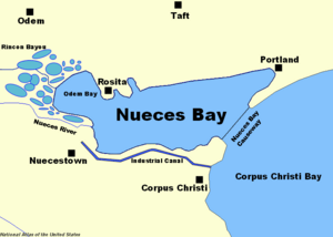
Nueces Bay is a bay in South Texas. It is connected to Corpus Christi Bay. The bay is located in San Patricio and Nueces Counties. The Nueces River flows into the bay. This creates a natural estuary, which is a place where fresh river water mixes with salty ocean water. This mix makes the bay very important for nature and the local economy.
Nueces Bay is a home for many fish and shellfish. These creatures help feed different kinds of birds and other wildlife. However, pollution from factories on the southern shore is a problem. This pollution has stopped oyster farming in the bay. Oil and chemical production are big industries in the nearby cities of Corpus Christi and Portland. These cities are on the eastern side of the bay. They are connected by the Nueces Bay Causeway.
Farms cover much of the northern shore of the bay. Many of these farms are still owned by families who settled there long ago. Old communities like Rosita and West Portland are also in this area. To the west, you'll find the Odem Bay extension. This part of the bay gets water from Rincon Bayou and a large marsh area. This marsh was formed by the Nueces River delta. The old settlement of Nuecestown is just south of the river's mouth. It is now part of Corpus Christi.
Contents
History of Nueces Bay
Nueces Bay was formed about 9,000 years ago. This happened as sea levels rose after the last ice age. The sea level became stable 6,000 years later. This is when Nueces Bay got its current shape.
Early People and Names
The first people to live near the bay were the Aransas Indians. They were nomads who lived in the area about 8,000 years ago. They stayed until about 1300 CE. The Karankawa Indians arrived later. They were living there when Europeans first came to the area.
The name Nueces means "nuts" in Spanish. This name comes from the pecan trees that grew along the Nueces River. Spanish explorer Alonso De León saw these trees in 1689. It is not clear when the bay got this name. In 1747, a Spanish captain named Joaquín de Orobio y Basterra called it San Miguel Arcángel. An 1835 map of Texas called it Papelote or "wastepaper" Bay.
The bay might have first appeared on a Spanish map in 1527. It was shown as the mouth of the Río Escondido, or "hidden river." This river is believed to be the Nueces River. French explorer René-Robert Cavelier, Sieur de La Salle sailed into the bay in 1685. He thought it was the Mississippi River by mistake.
Settlement Attempts
Spanish colonial governor José de Escandón planned a town called Villa de Vedoya. It was meant to be at the mouth of the Nueces River. About 50 families were sent there in 1749. But they could not start the settlement because they did not have enough supplies. Later, missionaries thought about moving a mission there. This was the Nuestra Señora del Refugio Mission. But they decided not to because of conflicts with the Lipan Apaches.
Germans also tried to settle the same area. But the French turned them away during the Pastry War in the 1830s. In the next decade, a plan was made for a colony for freed slaves. This idea came from an abolitionist named Benjamin Lundy. But he had to cancel it when the Texas Revolution began.
Growth of Communities
Corpus Christi is believed to be the first lasting settlement on the bay. It started as a trading post in 1839 on the southeastern shore. It grew into a major Texas port. By 2000, it had a population of 277,454 people.
In 1852, a settlement was finally started where the Nueces River meets Nueces Bay. This was done by Henry Kinney, who also founded Corpus Christi. German and English settlers called this community "the Motts." This was because of nearby tree clusters. Its official name was Nuecestown. Mexican bandits attacked it in 1875. But it recovered and grew to 200 people by 1896. The town declined after the railroad bypassed it in 1905. Today, it is part of Corpus Christi.
North of the bay, the Coleman-Fulton Pasture Company owned a large part of San Patricio County. They used it for ranching after the Texas Revolution. David Sinton and later Charles Phelps Taft were involved with this company. Towns nearby, Sinton and Taft, are named after them. They sold land on the northeast of Nueces Bay to George H. Paul. He hired Mexican immigrants to clear the land of mesquite trees. He started a ranching community there. It was later named West Portland. Most of the land in this community is still owned by the families of the first owners.
The town of Portland is on the far northeast of the bay. It was also started with land bought from the Coleman-Fulton Pasture Company. Future State Senator John G. Willacy helped with this, along with a company from New England. Portland grew steadily. By 2000, its population was 14,827.
To the northwest of the bay, on the Whites Point peninsula, a settlement began around 1866. A cattledriver named Darius Rachal bought land there. Soon after his purchase, many people from the White family died from yellow fever. An epidemic swept the area, killing 14 people. Rachal used his land to raise cattle, grow cotton, and sell land to new settlers. A post office was opened there in 1892. It was named Rosita, meaning "little flower." The names "White Point" and "Rachal" were not approved by the United States Postal Service. After a gas explosion in 1915 and two big hurricanes, including a 1919 storm that killed 26 residents (about 50 in Portland and 47 in Corpus Christi), the post office closed in 1919. By the next year, most people had moved to Odem.
Features of Nueces Bay
Nueces Bay covers about 28.9 square miles (74.9 square kilometers). It receives water from the Nueces River basin, which is 16,950 square miles (43,900 square kilometers). The bay is about 2.3 feet (0.7 meters) deep on average. It holds about 39,700 acre-feet (49 million cubic meters) of water.
The bay is the southern end of the Texas Coastal Plain. This plain stretches northeast to Galveston Bay. Nueces Bay is also where the grassy coastal plain changes to the dry, brushy area of South Texas. The Nueces River flows into the bay at its southwesternmost point. North of the river's entrance is the Odem Bay extension. This area has shallow marshes fed by many tidal streams, including Rincon Bayou. Whites Point is to the east of this extension.
South of Whites Point, at the mouth of Odem Bay, there is an oil field. This is near the many factories on the southwestern shore. The southern shore is narrow because of an industrial canal. This canal was dug south to the Port of Corpus Christi. The Nueces Bay Causeway crosses the mouth of Nueces Bay. This mile-long (1.6 km) causeway connects Rincon Point to Indian Point and leads to Portland. West Portland is on the bay's shoreline as it curves north and west. This area has many piers and homes. The bay then goes back west to Whites Point on the north shore, which is mostly used for farming.
Ecosystem and Wildlife
The Nueces estuary is home to many different kinds of wildlife. However, the amount of fresh water flowing from the Nueces River has decreased. This happened after the Choke Canyon Reservoir was built in 1985. This has made the bay saltier. It has harmed the natural homes for oysters and shrimp. To help, the City of Corpus Christi, Texas Parks and Wildlife Department, and other state groups are working to bring more fresh water back into the bay.
Marine Life
The Odem Bay extension has less salt. It acts as a nursery for shrimp. These shrimp then move to Nueces Bay in the spring. Oyster beds are common throughout the bay. They are good hiding spots for fish like trout, black drum, flounder, and redfish. These fish need to be protected from too much fresh water to survive.
Bird Populations
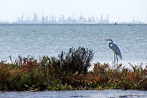
Many types of birds live in the bay. They are supported by the water life. You can see birds like the black skimmer, brown pelican, great blue heron, egret, laughing gull, roseate spoonbill, tern, and white ibis. They are especially common near the mouth of Rincon Bayou. Local groups like the Coastal Bend Bays and Estuaries program are helping birds. They add crushed oyster shells to small islands in the bay. This helps birds nest better. They also restore marshes near the Nueces Bay Causeway. This increases fish populations, which helps feed the birds.
Other Animals
At the nearby Nueces Delta Preserve, many birds have been seen. Other animals observed there include bobcats, coyotes, feral hogs, mountain lions, rattlesnakes, Texas spiny lizards, western diamondbacks, and white-tailed deer.
Industry and Environmental Concerns

Oil has been pumped from the bay since 1912. But recreational fishing has been important since people first lived in the area. In the early 1970s, recreational fishing brought in $17 million to the local economy each year. Commercial fishermen added $27.3 million.
Pollution and Cleanup Efforts
Commercial oyster farming was common in the bay until 1995. That year, the Texas Department of State Health Services stopped it. This was because oysters had unhealthy levels of zinc. Oysters are filter feeders, meaning they take in things from the water. The average zinc level was nearly 2500 mg/kg. Healthy levels are around 700 mg/kg.
It is believed that the American Smelting and Refining Company's Encycle Texas Incorporated caused the high zinc levels. They ran a zinc refinery there from 1942 to 1985. The Nueces Bay Power Station also likely released zinc used for cooling until 2002. Since then, zinc levels in the bay have dropped to just under 1000 mg/kg. This is still higher than healthy levels. The power station is now controlled by the Topaz Power Group.
The Texas Commission on Environmental Quality has a program called the Total Maximum Daily Load Program. This program measures pollutants in the Nueces watershed. It aims to make the bay safe again. Pesticides from the many farms on the north shore can also harm the environment when they seep into the bay.
Oil Spills
Several oil spills have happened because of the large petroleum industry on the south shore of Nueces Bay. In 1984, about 20,000 gallons (75,700 liters) of oil leaked from a broken pipeline. This blackened 5 miles (8 km) of the shore. Ten years later, Koch Industries, which owns a refinery on the bay, caused a major spill. About 100,000 gallons (378,500 liters) of oil were released. This created a 12-mile (19 km) oil slick that reached Corpus Christi Bay.
The Environmental Protection Agency fined Koch Industries $30 million for the spill in 2000. Later, the company gave $2.5 million to the state of Texas. This money was used to improve the bay's water quality.
 | Selma Burke |
 | Pauline Powell Burns |
 | Frederick J. Brown |
 | Robert Blackburn |


