
San Antonio Bay facts for kids
Quick facts for kids San Antonio Bay |
|
|---|---|

The shore of San Antonio Bay
|
|

San Antonio Bay
Location in Texas
|
|

View from the International Space Station
|
|
| Location | Texas Gulf Coast |
| Coordinates | 28°18′19″N 96°44′17″W / 28.30528°N 96.73806°W |
| River sources | Guadalupe River |
| Ocean/sea sources | Gulf of Mexico |
| Basin countries | United States |
| Surface area | 143,000 acres (58,000 ha) |
San Antonio Bay is a large bay on the Texas Gulf Coast. It sits between Matagorda and Aransas Bay. This bay is mostly filled with water from the San Antonio and Guadalupe rivers. It is located where the Guadalupe River meets the sea, about 55 miles (89 km) northeast of Corpus Christi. It is also about 130 miles (209 km) southeast of San Antonio.
Matagorda Island protects San Antonio Bay from the Gulf of Mexico. This means only a little ocean water mixes with the bay water. Because the bay is far from major shipping routes, it does not have big ports like those on Aransas Bay and Corpus Christi Bay to the south. San Antonio Bay is one of seven main estuaries along the Texas Gulf Coast. An estuary is where a river meets the sea. The Aransas National Wildlife Refuge is on the southwest side of the bay. Many different kinds of animals live here, making up for the small number of people.
Contents
History of San Antonio Bay
Who Lived by the Bay?
The Karankawa Indians used to camp near the Guadalupe River delta and San Antonio Bay. They also lived on Matagorda Island, which is across the bay. In 1776, Captain Luis Cazorla from Presidio La Bahía visited the island. He found that the Karankawa had caused problems for shipwrecked sailors. For a short time, he convinced the Indian leaders to help shipwreck survivors.
In 1793, an effort was made to convert the Karankawa. This happened when Mission Refugio was built on San Antonio Bay. A friar named José Francisco Garza found a shallow path the Indians used to travel to the mainland. To stop the Karankawa from using Matagorda Island to cause trouble, the leader Juan Cortés burned plants around this path. No permanent settlement was ever built on the island.
Early Settlers and Conflicts
White settlers arrived in the town of Hynesville in the 1800s. The Karankawa began to cause problems for these settlers, like taking their animals. Because of this, the settlers fought the Indians in the 1852 Battle of Hynes Bay. This battle was near the Hynes Bay part of San Antonio Bay. The Karankawa lost the battle and moved away, finding safety across the Rio Grande in Tamaulipas.
A few years later, the Hynes Bay area started to fill with mud. This made it shallow and hard for boats to use. Stories from Hynesville say that alligators filled the bay and even killed some people.
Developing Towns and Challenges
In the early 1900s, Preston R. Austin wanted to build a new port on the western shore. He started the town of Austwell in 1911. He began digging a channel in 1914. But the channel quickly filled with mud and was not used.
Meanwhile, on the eastern shore, the city of Seadrift began to grow. It had been started after the American Civil War. Seadrift became a good place for fishing and shipping. The town was likely named for floating wood swept ashore by the Guadalupe River. It became an official city in 1912. By 1914, it had 1,250 people. However, a hurricane hit the area in 1919, and the town's growth slowed down. In 1926, only 321 people lived there. The population slowly grew back. By 1990, it was bigger than before, partly because many Vietnamese refugees moved there after the Vietnam War. In 2000, Seadrift had 1,352 residents.
Features of San Antonio Bay

What is the Land Like?
The land around the bay is part of the Texas Coastal Plain. It has grassy prairies. These prairies have conifer trees and hardwood trees that can handle a lot of water. Most of the land nearby is used for farming. However, the Aransas National Wildlife Refuge is kept safe for animals.
How Deep is the Bay?
On average, the San Antonio Bay system is about 2 meters (6.6 ft) deep. It covers about 531 square kilometers (205 sq mi). The system includes the main bay and its smaller parts. The main smaller parts are Espiritu Santo Bay to the east, Hynes Bay to the northwest, and Guadalupe Bay to the north.
Water Flow and Saltiness
San Antonio Bay and its smaller parts form one of seven major estuaries along the Texas Gulf Coast. It gets water from the San Antonio and Guadalupe rivers, which flow together. About 116 cubic meters (30,646 gallons) of water flow into the bay every second.
Only a small amount of ocean water mixes with the bay water. This happens at Cedar Bayou and Pass Cavallo. Because of this, the bay's water is less salty than the ocean. The bay's saltiness is about 13 parts per thousand (ppt). Ocean water is usually about 35 ppt salty.
Ecosystem and Wildlife
Fish in the Bay
Many different animals live in and around San Antonio Bay. According to Texas Parks and Wildlife, you can find these fish in the bay:
- palmetto bass
- striped bass
- hardhead catfish
- black drum
- red drum
- crevalle jack
- southern kingfish
- ladyfish
- lefteye flounder
- pinfish
- spotted seatrout
- sheepshead
Birds and Other Animals
The shores along the bay, especially the Aransas National Wildlife Refuge, are home to many birds. These include the endangered whooping crane, pelicans, herons, egrets, roseate spoonbills, shorebirds, ducks, and geese.
Other animals found here include American alligators, collared peccaries, feral hogs, coyotes, bobcats, raccoons, and white-tailed deer. You can also find clams and crabs. In June 2010, several pelicans that were rescued and cleaned after the Deepwater Horizon oil spill were brought to the shore of San Antonio Bay.
Industry Around the Bay
Shipping and Jobs
San Antonio Bay is almost cut off from the Gulf of Mexico by barrier islands. This means it does not have a large shipping industry. The only important port on the bay is Seadrift. A shipping channel has been dug there to connect to the Gulf Intracoastal Waterway. Most people living near the bay work at chemical, crab-picking, and aluminum factories.
Oyster Farming
For hundreds of years, oyster farming has been a main part of the local economy. However, in December 2009, people stopped harvesting oysters for sale. This happened after a virus was found in some exported oysters, leading to a recall.
Images for kids
-
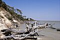
The shore of San Antonio Bay
-
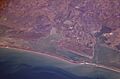
View from the International Space Station
-
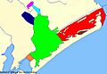
Map showing San Antonio Bay and its extensions
