
Delaware and Raritan Canal facts for kids
|
Delaware and Raritan Canal
|
|

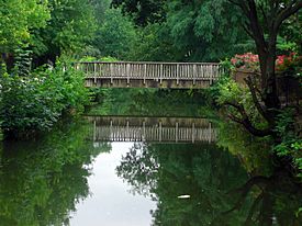
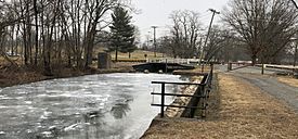
A section of the canal as seen from a footbridge (2013)
|
|
| Location | New Jersey, United States |
|---|---|
| Built | 1834 |
| NRHP reference No. | 73001105 |
Quick facts for kids Significant dates |
|
| Added to NRHP | May 11, 1973 |

The Delaware and Raritan Canal (often called the D&R Canal) is a historic waterway in central New Jersey, United States. It was built in the 1830s to connect the Delaware River to the Raritan River. This canal made it much easier and faster to transport goods between Philadelphia and New York City. It was especially important for moving coal from the mines in eastern Pennsylvania. Before the canal, ships had to travel all the way down the Delaware River, around Cape May, and up the Atlantic coast. The canal saved many miles and avoided dangerous ocean travel.
Contents
Building the D&R Canal: A Journey Through Time
The idea for a canal connecting the Raritan and Delaware Rivers is very old. William Penn, who founded Pennsylvania, first suggested it in the 1690s. Such a canal would cut 100 miles off the trip from Philadelphia to New York. It would also mean boats would not have to go into the open Atlantic Ocean.
Early Plans and Challenges
In 1816, New Jersey's government created a group of three people to study the idea. One of them was John Rutherfurd, a former U.S. Senator and a big landowner. Rutherfurd hired John Randel Jr. to survey the best path for the canal. Randel was a skilled surveyor who had worked on the map of New York City.
Randel spent two months surveying the route. He also figured out how much water the canal would need. He found that it would use very little water from local streams. This meant there would still be enough water for local mills. Even with Randel's good report, it took a long time for the project to start. People who were against the canal managed to stop it until 1830.

Starting Construction: A Big Effort
On February 4, 1830, the New Jersey government finally passed a law to create the D&R Canal. On the same day, they also approved the Camden and Amboy Rail Road. The canal's plan set aside $1.5 million for building. It also said the canal had to be finished within eight years. The canal was meant to be a public road, but the company could charge fees for boats and goods.
The canal almost didn't get built because not enough people bought shares to fund it. But then, Robert F. Stockton stepped in. He was the grandson of Richard Stockton, who signed the Declaration of Independence. Robert Stockton promised his own family's money to make sure the work continued.
Most of the canal was dug by hand tools. Many Irish immigrants did this hard work. Construction started in 1830 and finished in 1834. It cost about $2,830,000. When the canal first opened, teams of mules pulled the canal boats. Steam engines were not yet used for this kind of work.
The Canal's Golden Age and Decline
The canal was used the most during the 1860s and 1870s. It mainly carried coal from Pennsylvania to New York City. This was a time when New York City was growing fast due to the Industrial Revolution.
In 1872, the D&R Canal Company joined with several railroads to form the United New Jersey Railroad and Canal Company. This new company was then leased by the Pennsylvania Railroad. Over time, the canal became less important. Railroads could move goods much faster than canals. The D&R Canal stayed open until 1932.
Later, parts of the canal were filled in or covered. The section between Trenton and Bordentown was filled for roads and railways. Other parts were put into underground pipes. This happened in Trenton in 1952 for the Trenton Freeway. Another part was covered in New Brunswick in 1984 for New Jersey Route 18.
The Canal's Path
_from_the_overpass_for_Southard_Street_in_Trenton_City,_Mercer_County,_New_Jersey.jpg)
The main part of the canal runs from Bordentown on the Delaware River to New Brunswick on the Raritan River. There is also a "feeder canal." This section brings water into the main canal. It goes 22 miles (35 km) north from Trenton. It runs along the east bank of the Delaware River to Bull's Island near Frenchtown. The feeder canal collects water from higher areas to the north. This water then flows into the highest part of the main canal.
The total length of the canal system was about 66 miles (106 km). The main section was 44 miles (71 km) long. It was 75 feet (23 m) wide and 8 feet (2.4 m) deep. The feeder canal was 22 miles (35 km) long. It was 60 feet (18 m) wide and 6 feet (2 m) deep.
Sections That Changed
Some parts of the D&R Canal in Trenton are now covered by the Trenton Freeway (U.S. Route 1). The water still flows underneath, but people cannot use these parts. The section that connected to the Delaware River in Bordentown is also no longer used. In Trenton, New Jersey Route 129 was built over another part of the canal in 1996. Another section south of Trenton is in Hamilton Township, Mercer County, New Jersey. It is between Trenton and the Crosswicks Creek.

Locks and Spillways
Locks were used to help boats move up or down when the canal's height changed. Many of these locks are still along the canal. However, the old lock gates have been replaced. Small dams and water outlets are now on the upstream side. The downstream gates have been removed. This means the water inside the locks is now level with the water on the downstream side. Some locks have been buried or removed because of new construction projects.
There are also many spillways along the canal. These allowed extra water to drain from the canal into nearby rivers during heavy rains. You can see a spillway as a dip in the path next to the canal. Some have stones for mules to walk on, but they are hard for bicycles to cross. When the water stops flowing, you might see plants and animals that live in still water.

Rivers Connected to the Canal
- Delaware River: This river feeds water into the Delaware and Raritan Canal. A feeder canal brings water from the north, starting at Bulls Island, to the southern end of the D&R Canal near Trenton.
- Millstone River: This river runs next to the Delaware and Raritan Canal from Princeton north to Manville.
- Raritan River: This river runs next to the Delaware and Raritan Canal from Manville north and east to New Brunswick. The northern end of the Delaware and Raritan Canal is in New Brunswick.
A Historic Landmark

The Delaware and Raritan Canal was added to the National Register of Historic Places on May 11, 1973. Many old canal houses, where the bridge tenders lived, are also part of this historic listing. Examples include the Blackwells Mills Canal House and the Port Mercer Canal House.
Delaware and Raritan Canal State Park
In 1974, most of the canal system became a New Jersey state park. It is still a park today. People use it for canoeing, kayaking, and fishing. There is a path along the canal called the D&R Canal Trail. This used to be the "tow path" where mules pulled barges. Now, people use it for hiking, jogging, bicycling, and horseback riding.
About 36 miles (58 km) of the main canal still exist. All 22 miles (35 km) of the feeder canal are also still there. The feeder canal path, which was once a railroad, is great for bicycling. The park is managed by the New Jersey Division of Parks and Forestry.
You can get to the canal from many places along its route. Small parking areas are often found at road crossings. One of the most beautiful parts of the D&R Canal state park is near Lake Carnegie in Princeton, New Jersey. Here, the canal is on one side of the path and the lake is on the other. Another nice section is next to the Colonial Park Arboretum and Gardens in East Millstone.
When the canal was used for transportation, New Jersey was mostly farmland. Now, as Howard Green of the New Jersey Historical Commission said, "It is one of the most beloved parks in the state." He called it "a sinewy, snake-like greenway through one of the most heavily populated parts of the world." The canal has changed from a busy transport route to a peaceful green space.
Gallery
-
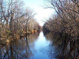
A rural area along the canal.
-
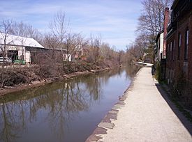
The feeder canal in Lambertville, New Jersey.
-
Another view from Lambertville.
-
The Raritan Canal at South Bound Brook.
-
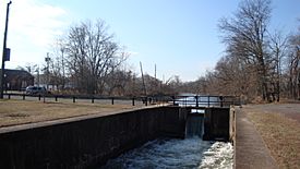
A parking area, lock, spillway, and trail in Ewing Township, NJ.


