Hobucken, North Carolina facts for kids
Quick facts for kids
Hobucken, North Carolina
|
|
|---|---|

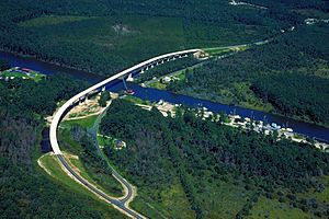
Aerial view of a stretch of the Intracoastal Waterway in Pamlico County, North Carolina, USA. The U.S. Army Corps of Engineers constructed the Hobucken Bridge over the waterway to replace an old swing-style drawbridge. The bridge carries NC state routes 33 and 304 over the waterway.
|
|
| Country | United States |
| State | North Carolina |
| County | Pamlico |
| Area | |
| • Total | 5.11 sq mi (13.24 km2) |
| • Land | 5.08 sq mi (13.16 km2) |
| • Water | 0.03 sq mi (0.08 km2) |
| Elevation | 0 ft (0 m) |
| Population
(2020)
|
|
| • Total | 99 |
| • Density | 19.49/sq mi (7.53/km2) |
| Time zone | UTC-5 (Eastern (EST)) |
| • Summer (DST) | UTC-4 (EDT) |
| ZIP code |
28537
|
| Area code(s) | 252 |
| GNIS feature ID | 2628636 |
Hobucken is a small community located in Pamlico County, North Carolina, in the United States. It's known as an unincorporated community, which means it doesn't have its own local government like a city or town. Instead, it's managed by the county. Hobucken is also a census-designated place (CDP). This means the government counts the people living there for official records, even though it's not a formal city.
Contents
Exploring Hobucken, North Carolina
Hobucken is found in the eastern part of North Carolina. It's in Pamlico County, which is known for its waterways and coastal areas. The community is close to the Intracoastal Waterway. This is a long channel that boats use to travel along the coast.
Getting Around Hobucken
Two main roads pass through Hobucken: North Carolina Highway 33 and North Carolina Highway 304. These highways help people travel to and from the community. A special bridge, the Hobucken Bridge, crosses the Intracoastal Waterway here. It was built by the U.S. Army Corps of Engineers. This bridge helps connect different parts of the area.
What is a ZIP Code?
Hobucken has its own ZIP code, which is 28537. A ZIP code is a special number used by the postal service. It helps make sure mail gets to the right place quickly. Every house and business in Hobucken uses this code for their mail.
People in Hobucken
As of the 2020 census, 99 people lived in Hobucken. This number helps us understand how many people call this community home.
| Historical population | |||
|---|---|---|---|
| Census | Pop. | %± | |
| 2020 | 99 | — | |
| U.S. Decennial Census | |||
Understanding a Census-Designated Place
A census-designated place, or CDP, is an area that the United States Census Bureau defines. They do this for statistical purposes. It helps them collect and share information about populations in specific areas. CDPs don't have their own local government. They are just areas where people live that the census bureau tracks.
See also
 In Spanish: Hobucken para niños
 | Jackie Robinson |
 | Jack Johnson |
 | Althea Gibson |
 | Arthur Ashe |
 | Muhammad Ali |


